- O repozytorium
- Kolekcje
- Indeksy
- Historia przeglądania
-
Repozytoria RCIN
-
 INSTYTUT ARCHEOLOGII I ETNOLOGII POLSKIEJ AKADEMII NAUK
-
 INSTYTUT BADAŃ LITERACKICH POLSKIEJ AKADEMII NAUK
-
 INSTYTUT BADAWCZY LEŚNICTWA
-
 INSTYTUT BIOLOGII DOŚWIADCZALNEJ IM. MARCELEGO NENCKIEGO POLSKIEJ AKADEMII NAUK
-
 INSTYTUT BIOLOGII SSAKÓW POLSKIEJ AKADEMII NAUK
-
 INSTYTUT CHEMII FIZYCZNEJ PAN
-
 INSTYTUT CHEMII ORGANICZNEJ PAN
-
 INSTYTUT FILOZOFII I SOCJOLOGII PAN
-
 INSTYTUT GEOGRAFII I PRZESTRZENNEGO ZAGOSPODAROWANIA PAN
-
 INSTYTUT HISTORII im. TADEUSZA MANTEUFFLA POLSKIEJ AKADEMII NAUK
-
 INSTYTUT JĘZYKA POLSKIEGO POLSKIEJ AKADEMII NAUK
-
 INSTYTUT MATEMATYCZNY PAN
-
 INSTYTUT MEDYCYNY DOŚWIADCZALNEJ I KLINICZNEJ IM.MIROSŁAWA MOSSAKOWSKIEGO POLSKIEJ AKADEMII NAUK
-
 INSTYTUT PODSTAWOWYCH PROBLEMÓW TECHNIKI PAN
-
 INSTYTUT SLAWISTYKI PAN
-
 SIEĆ BADAWCZA ŁUKASIEWICZ - INSTYTUT TECHNOLOGII MATERIAŁÓW ELEKTRONICZNYCH
-
 MUZEUM I INSTYTUT ZOOLOGII POLSKIEJ AKADEMII NAUK
-
 INSTYTUT BADAŃ SYSTEMOWYCH PAN
-
 INSTYTUT BOTANIKI IM. WŁADYSŁAWA SZAFERA POLSKIEJ AKADEMII NAUK
-
- Wyszukaj w całym Repozytorium
- Piśmiennictwo i mapy
- Archeologia
- Baza Młynów
- Nauki przyrodnicze
Wyszukiwanie zaawansowane
Wyszukiwanie zaawansowane
Wyszukiwanie zaawansowane
Wyszukiwanie zaawansowane
Wyszukiwanie zaawansowane

Obiekt
Dostępne formaty:
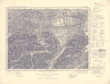
Pobierz wszystkieTytuł: Karte des Deutschen Reiches 1:100 000, 663. Munrau
Twórca:
Bawaria (Niemcy ; land). Topographisches Bureau. Redaktor ; Niemcy. Hauptvermessungsabteilung XIII. Wydawca
Data wydania/powstania:
Typ zasobu:
Inny tytuł:
Karte des Deutschen Reiches 1:100 000 ; 663
Wydawca:
Hauptvermessungsabteilung XIII
Miejsce wydania:
Opis:
Scale 1:100 000 ; 1 map ; 30x39 cm, on sheet 40x52 cm ; On the bottom margin: Berichtigt 1935. Neudruck 1951, Landesaufnahme, Berlin SW 68
Typ obiektu:
Czasopismo/Seria/cykl:
Karte des Deutschen Reiches 1:100 000
Szczegółowy typ zasobu:
Format:
Identyfikator zasobu:
Źródło:
CBGiOŚ. IGiPZ PAN, call no. C.187/108 ; kliknij tutaj, żeby przejść
Język:
Zakres:
Prawa:
Zasady wykorzystania:
Digitalizacja:
Institute of Geography and Spatial Organization of the Polish Academy of Sciences
Lokalizacja oryginału:
Dofinansowane ze środków:
Dostęp:
Kolekcje, do których przypisany jest obiekt:
- Repozytorium Cyfrowe Instytutów Naukowych > Kolekcje Partnerów > Instytut Geografii i Przestrzennego Zagospodarowania PAN > Biblioteka Instytutu
- Repozytorium Cyfrowe Instytutów Naukowych > Kolekcje Partnerów > Instytut Geografii i Przestrzennego Zagospodarowania PAN > Biblioteka Instytutu > Mapy i atlasy
- Repozytorium Cyfrowe Instytutów Naukowych > Piśmiennictwo > Mapy/Atlasy
Data ostatniej modyfikacji:
2 paź 2020
Data dodania obiektu:
17 gru 2019
Liczba pobrań / odtworzeń:
80
Wszystkie dostępne wersje tego obiektu:
https://rcin.org.pl./publication/97036
Wyświetl opis w formacie RDF:
Wyświetl opis w formacie RDFa:
Wyświetl opis w formacie OAI-PMH:
| Nazwa wydania | Data |
|---|---|
| 663. Munrau, 1951 | 2 paź 2020 |
Obiekty Podobne
Bawaria (Niemcy ; land). Topographisches Bureau. Redaktor Niemcy. Hauptvermessungsabteilung XIII. Wydawca Prusy. Landesaufnahme. Wydawca
Niemcy. Reichsamt für Landesaufnahme. Wydawca Bawaria (Niemcy ; land). Topographisches Bureau. Redaktor
Bawaria (Niemcy ; land). Topographisches Bureau. Redaktor Bawaria (Niemcy ; land). Bayerisches Landesvermessungsamt. Topographische Zweigstelle. Wydawca
Bawaria (Niemcy ; land). Topographisches Bureau. Redaktor Bawaria (Niemcy ; land). Bayerisches Landesvermessungsamt. Topographische Zweigstelle. Wydawca
Niemcy. Reichsamt für Landesaufnahme. Wydawca Bawaria (Niemcy ; land). Topographisches Bureau. Redaktor
Bawaria (Niemcy ; land). Topographisches Bureau. Redaktor Niemcy. Reichsamt für Landesaufnahme. Wydawca
Bawaria (Niemcy ; land). Topographisches Bureau. Redaktor Wirtembergia (Niemcy). Ministerium des Innern. Hauptvermessungsabteilung XII. Wydawca Prusy. Landesaufnahme. Wydawca
Bawaria (Niemcy ; land). Topographisches Bureau. Redaktor


