- Search in all Repository
- Literature and maps
- Archeology
- Mills database
- Natural sciences
Advanced search
Advanced search
Advanced search
Advanced search
Advanced search

Object
Available formats:
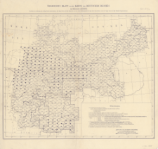
Download allTitle: Übersichts-Blatt zu der Karte des Deutschen Reiches im maßstabe 1:100 000
Creator:
Prusy. Landesaufnahme ; Prusy. Königliche Preussische Landesaufnahme ; Niemcy. Reichsamt für Landesaufnahme
Date issued/created:
Resource type:
Subtitle:
[Skorowidz arkuszy "Karte des Deutschen Reiches im maßstabe 1:100 000"]
Publisher:
Place of publishing:
Description:
Scale 1:100 000 ; Maps ; 30x37 cm or smaller ; Prime meridian was Ferro, later Greenwich ; German series of topographic maps. Each sheet covers about 30' in longitude and 15' in geographical latitude. Sheet's title consist of a geographical name (the name of the largest town or other geographic object) and the order number. The individual sheets had several versions or reissues
Relation:
Karte des Deutschen Reiches 1:100 000
Detailed Resource Type:
Resource Identifier:
Source:
CBGiOŚ. IGiPZ PAN, call no. C.187/0
Language:
Rights:
Terms of use:
Digitizing institution:
Institute of Geography and Spatial Organization of the Polish Academy of Sciences
Original in:
Projects co-financed by:
Access:
Object collections:
- Digital Repository of Scientific Institutes > Partners' collections > Institute of Geography and Spatial Organization PAS (IGiPZ PAN) > Library
- Digital Repository of Scientific Institutes > Partners' collections > Institute of Geography and Spatial Organization PAS (IGiPZ PAN) > Library > Maps and atlases
- Digital Repository of Scientific Institutes > Literature > Maps/Atlases
Last modified:
Oct 2, 2020
In our library since:
Dec 19, 2019
Number of object content downloads / hits:
217
All available object's versions:
https://rcin.org.pl./publication/91788
Show description in RDF format:
Show description in RDFa format:
Show description in OAI-PMH format:
| Edition name | Date |
|---|---|
| Übersichts-Blatt zu der Karte des Deutschen Reiches im maßstabe 1:100 000, [przed 1939] | Oct 2, 2020 |
Objects Similar
Prusy. Königliche Preussische Landesaufnahme. Kartographische Abteilung
Niemcy. Reichsamt für Landesaufnahme. Wydawca Prusy. Landesaufnahme. Kartographische Abteilung. Redaktor Wydawca Prusy. Landesaufnahme. Wydawca
Prusy. Landesaufnahme Prusy. Königliche Preussische Landesaufnahme Niemcy. Reichsamt für Landesaufnahme
Instytut Wojskowo-Geograficzny (Warszawa). Wydawca Zakłady Graficzne B. Wierzbicki i Spółka. Drukarz

 INSTYTUT ARCHEOLOGII I ETNOLOGII POLSKIEJ AKADEMII NAUK
 INSTYTUT BADAŃ LITERACKICH POLSKIEJ AKADEMII NAUK
 INSTYTUT BADAWCZY LEŚNICTWA
 INSTYTUT BIOLOGII DOŚWIADCZALNEJ IM. MARCELEGO NENCKIEGO POLSKIEJ AKADEMII NAUK
 INSTYTUT BIOLOGII SSAKÓW POLSKIEJ AKADEMII NAUK
 INSTYTUT CHEMII FIZYCZNEJ PAN
 INSTYTUT CHEMII ORGANICZNEJ PAN
 INSTYTUT FILOZOFII I SOCJOLOGII PAN
 INSTYTUT GEOGRAFII I PRZESTRZENNEGO ZAGOSPODAROWANIA PAN
 INSTYTUT HISTORII im. TADEUSZA MANTEUFFLA POLSKIEJ AKADEMII NAUK
 INSTYTUT JĘZYKA POLSKIEGO POLSKIEJ AKADEMII NAUK
 INSTYTUT MATEMATYCZNY PAN
 INSTYTUT MEDYCYNY DOŚWIADCZALNEJ I KLINICZNEJ IM.MIROSŁAWA MOSSAKOWSKIEGO POLSKIEJ AKADEMII NAUK
 INSTYTUT PODSTAWOWYCH PROBLEMÓW TECHNIKI PAN
 INSTYTUT SLAWISTYKI PAN
 SIEĆ BADAWCZA ŁUKASIEWICZ - INSTYTUT TECHNOLOGII MATERIAŁÓW ELEKTRONICZNYCH
 MUZEUM I INSTYTUT ZOOLOGII POLSKIEJ AKADEMII NAUK
 INSTYTUT BADAŃ SYSTEMOWYCH PAN
 INSTYTUT BOTANIKI IM. WŁADYSŁAWA SZAFERA POLSKIEJ AKADEMII NAUK


