- About project
- Collections
- Indexes
- Recently viewed
-
RCIN Repositories
-
 INSTYTUT ARCHEOLOGII I ETNOLOGII POLSKIEJ AKADEMII NAUK
-
 INSTYTUT BADAŃ LITERACKICH POLSKIEJ AKADEMII NAUK
-
 INSTYTUT BADAWCZY LEŚNICTWA
-
 INSTYTUT BIOLOGII DOŚWIADCZALNEJ IM. MARCELEGO NENCKIEGO POLSKIEJ AKADEMII NAUK
-
 INSTYTUT BIOLOGII SSAKÓW POLSKIEJ AKADEMII NAUK
-
 INSTYTUT CHEMII FIZYCZNEJ PAN
-
 INSTYTUT CHEMII ORGANICZNEJ PAN
-
 INSTYTUT FILOZOFII I SOCJOLOGII PAN
-
 INSTYTUT GEOGRAFII I PRZESTRZENNEGO ZAGOSPODAROWANIA PAN
-
 INSTYTUT HISTORII im. TADEUSZA MANTEUFFLA POLSKIEJ AKADEMII NAUK
-
 INSTYTUT JĘZYKA POLSKIEGO POLSKIEJ AKADEMII NAUK
-
 INSTYTUT MATEMATYCZNY PAN
-
 INSTYTUT MEDYCYNY DOŚWIADCZALNEJ I KLINICZNEJ IM.MIROSŁAWA MOSSAKOWSKIEGO POLSKIEJ AKADEMII NAUK
-
 INSTYTUT PODSTAWOWYCH PROBLEMÓW TECHNIKI PAN
-
 INSTYTUT SLAWISTYKI PAN
-
 SIEĆ BADAWCZA ŁUKASIEWICZ - INSTYTUT TECHNOLOGII MATERIAŁÓW ELEKTRONICZNYCH
-
 MUZEUM I INSTYTUT ZOOLOGII POLSKIEJ AKADEMII NAUK
-
 INSTYTUT BADAŃ SYSTEMOWYCH PAN
-
 INSTYTUT BOTANIKI IM. WŁADYSŁAWA SZAFERA POLSKIEJ AKADEMII NAUK
-
- Search in all Repository
- Literature and maps
- Archeology
- Mills database
- Natural sciences
Advanced search
Advanced search
Advanced search
Advanced search
Advanced search

Object
Available formats:
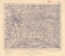
Download allTitle: Karte des Deutschen Reiches, 477. Oppeln
Creator:
Prusy. Landesaufnahme. Kartographische Abteilung. Redaktor
Date issued/created:
Resource type:
Subtitle:
Karte des Deutschen Reiches ; 477
Publisher:
Place of publishing:
Description:
Scale 1:100 000 ; 1 map ; 30x37 cm, on sheet 36x42 cm ; On the bottom margin: Aufgenommen v. der Topogr. Abtheilung der Kgl. Pr. Landesaufnahme 1881. Druck 1914 ; Prime meridian Ferro ; In the bottom corner of the map: N.12 ; Title from the panel: Karte des Deutschen Reichs 1:100 000 Sekt. 477
Type of object:
Relation:
Karte des Deutschen Reiches 1:100 000
Detailed Resource Type:
Format:
Resource Identifier:
Source:
CBGiOŚ. IGiPZ PAN, call no. C.187/239 ; click here to follow the link
Language:
Coverage:
Rights:
Terms of use:
Digitizing institution:
Institute of Geography and Spatial Organization of the Polish Academy of Sciences
Original in:
Projects co-financed by:
Access:
Object collections:
- Digital Repository of Scientific Institutes > Partners' collections > Institute of Geography and Spatial Organization PAS (IGiPZ PAN) > Library
- Digital Repository of Scientific Institutes > Partners' collections > Institute of Geography and Spatial Organization PAS (IGiPZ PAN) > Library > Maps and atlases
- Digital Repository of Scientific Institutes > Literature > Maps/Atlases
Last modified:
Oct 2, 2020
In our library since:
Dec 16, 2019
Number of object content downloads / hits:
117
All available object's versions:
https://rcin.org.pl./publication/98608
Show description in RDF format:
Show description in RDFa format:
Show description in OAI-PMH format:
| Edition name | Date |
|---|---|
| 477. Oppeln, 1914 | Oct 2, 2020 |
Objects Similar
Prusy. Landesaufnahme. Kartographische Abteilung. Redaktor
Prusy. Landesaufnahme. Kartographische Abteilung. Redaktor
Prusy. Landesaufnahme. Kartographische Abteilung. Redaktor
Prusy. Landesaufnahme. Kartographische Abteilung. Redaktor
Prusy. Landesaufnahme. Kartographische Abteilung. Redaktor
Prusy. Landesaufnahme. Kartographische Abteilung. Redaktor
Prusy. Landesaufnahme. Kartographische Abteilung. Redaktor
Prusy. Landesaufnahme. Kartographische Abteilung. Redaktor


