- Search in all Repository
- Literature and maps
- Archeology
- Mills database
- Natural sciences
Advanced search
Advanced search
Advanced search
Advanced search
Advanced search

Object
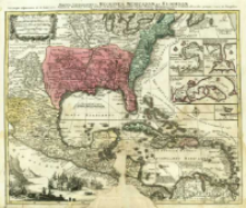
Title: Mappa Geographica Regionem Mexicanam Et Floridam Terrasque adiacentes, ut et Anteriores Americae Insulas, Cursus itidem et Reditus Navigantium versus flumen Missisipi et alias Colonias ob oculos ponens
Contributor:
Lotter, Tobias Conrad (1717–1777) : Ryt.
Publisher:
cura et sumtibus Tobiæ Conradi Lotteri Geographi et Chalcographi
Place of publishing:
Description:
Skala [ca 1:9 300 000] ; 1 mapa : miedzior., kolor. ręcznie ; 48x57 cm ; Południk zerowy Ferro, ustalony po obliczeniach przez katalogującego ; Mapy poboczne: Bahia Portus Belli ; Tractus Bahiae et Civitatis Havanae ; Tractus Civitatis Carthagena Castel eius ; La Vera Cruz ; Tyt. nad górną ramką ; W lewym dolnym rogu scena rodzajowa ; Mapa wydana wcześniej, ok. 1735 r. przez Matthäusa Seuttera
Detailed Resource Type:
Format:
Resource Identifier:
Source:
CBGiOŚ. IGiPZ PAN, call no. B.1644/79 ; click here to follow the link
Language:
Rights:
Terms of use:
Digitizing institution:
Institute of Geography and Spatial Organization of the Polish Academy of Sciences
Original in:
Projects co-financed by:
Programme Innovative Economy, 2010-2014, Priority Axis 2. R&D infrastructure ; European Union. European Regional Development Fund
Access:
Object collections:
- Digital Repository of Scientific Institutes > Partners' collections > Institute of Geography and Spatial Organization PAS (IGiPZ PAN) > Library
- Digital Repository of Scientific Institutes > Partners' collections > Institute of Geography and Spatial Organization PAS (IGiPZ PAN) > Library > Maps and atlases
- Digital Repository of Scientific Institutes > Literature > Maps/Atlases
Last modified:
Oct 2, 2020
In our library since:
Nov 22, 2013
Number of object content downloads / hits:
85
All available object's versions:
https://rcin.org.pl./publication/45003
Show description in RDF format:
Show description in RDFa format:
Show description in OAI-PMH format:
Objects Similar
Rabinowitz, A. R. Nottingham, B. G., Jr.
Ryser, J.
Raymond, M. A. V. Layne, J. N.
Bautista, Carlos Olszańska, Agnieszka Berezowska-Cnota, Teresa Fedyń, Hubert Jastrzębski, Tomasz Nowakowski, Robert Marcela, Agnieszka Selva, Nuria

 INSTYTUT ARCHEOLOGII I ETNOLOGII POLSKIEJ AKADEMII NAUK
 INSTYTUT BADAŃ LITERACKICH POLSKIEJ AKADEMII NAUK
 INSTYTUT BADAWCZY LEŚNICTWA
 INSTYTUT BIOLOGII DOŚWIADCZALNEJ IM. MARCELEGO NENCKIEGO POLSKIEJ AKADEMII NAUK
 INSTYTUT BIOLOGII SSAKÓW POLSKIEJ AKADEMII NAUK
 INSTYTUT CHEMII FIZYCZNEJ PAN
 INSTYTUT CHEMII ORGANICZNEJ PAN
 INSTYTUT FILOZOFII I SOCJOLOGII PAN
 INSTYTUT GEOGRAFII I PRZESTRZENNEGO ZAGOSPODAROWANIA PAN
 INSTYTUT HISTORII im. TADEUSZA MANTEUFFLA POLSKIEJ AKADEMII NAUK
 INSTYTUT JĘZYKA POLSKIEGO POLSKIEJ AKADEMII NAUK
 INSTYTUT MATEMATYCZNY PAN
 INSTYTUT MEDYCYNY DOŚWIADCZALNEJ I KLINICZNEJ IM.MIROSŁAWA MOSSAKOWSKIEGO POLSKIEJ AKADEMII NAUK
 INSTYTUT PODSTAWOWYCH PROBLEMÓW TECHNIKI PAN
 INSTYTUT SLAWISTYKI PAN
 SIEĆ BADAWCZA ŁUKASIEWICZ - INSTYTUT TECHNOLOGII MATERIAŁÓW ELEKTRONICZNYCH
 MUZEUM I INSTYTUT ZOOLOGII POLSKIEJ AKADEMII NAUK
 INSTYTUT BADAŃ SYSTEMOWYCH PAN
 INSTYTUT BOTANIKI IM. WŁADYSŁAWA SZAFERA POLSKIEJ AKADEMII NAUK


