- Wyszukaj w całym Repozytorium
- Piśmiennictwo i mapy
- Archeologia
- Baza Młynów
- Nauki przyrodnicze
Wyszukiwanie zaawansowane
Wyszukiwanie zaawansowane
Wyszukiwanie zaawansowane
Wyszukiwanie zaawansowane
Wyszukiwanie zaawansowane

Obiekt
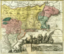
Tytuł: Recens Edita totius Novi Belgii, in America Septentrionali siti, delineatio.
Contributor:
Lotter, Tobias Conrad (1717–1777) : Wyd.
Publisher:
Place of publishing:
Description:
Skala [ca 1:2 200 000] ; 1 mapa : miedzior., kolor. ręcznie ; 50x57 cm ; Południk zerowy Ferro, ustalony po obliczeniach przez katalogującego ; W lewej, dolnej części kartusza herb Wielkiej Brytanii podtrzymywany przez putto, dalej symboliczna scena składania darów i uznania królowi Jerzemu II ; Pod kartuszem widok Nowego Jorku wraz z objaśnieniem ważniejszych punktów miasta: Neu Jorck sive Neu Amsterdam ; W treści mapy, na poszczególnych obszarach Stanów Północno-Wchodnich, umieszczono miniatury występujących tam w 18 w. zwierząt . Na północny-zachód od rzeki Potomac (na mapie Sasquesahanough) przedstawiono miniaturę wioski Mohikanów ; Mapa po raz pierwszy wydana w ok. 1735 r. przez Matthäsa Seuttera. Tobias Conrad Lotter zmienił w swoim wydaniu tylko nazwisko wydawcy , umieszczając w kartuszu swoje
Detailed Resource Type:
Format:
Resource Identifier:
Source:
CBGiOŚ. IGiPZ PAN, sygn. B.1644/78 ; kliknij tutaj, żeby przejść
Language:
Rights:
Terms of use:
Digitizing institution:
Instytut Geografii i Przestrzennego Zagospodarowania Polskiej Akademii Nauk
Original in:
Projects co-financed by:
Program Operacyjny Innowacyjna Gospodarka, lata 2010-2014, Priorytet 2. Infrastruktura strefy B + R ; Unia Europejska. Europejski Fundusz Rozwoju Regionalnego
Access:
Kolekcje, do których przypisany jest obiekt:
- Repozytorium Cyfrowe Instytutów Naukowych > Kolekcje Partnerów > Instytut Geografii i Przestrzennego Zagospodarowania PAN > Biblioteka Instytutu
- Repozytorium Cyfrowe Instytutów Naukowych > Kolekcje Partnerów > Instytut Geografii i Przestrzennego Zagospodarowania PAN > Biblioteka Instytutu > Mapy i atlasy
- Repozytorium Cyfrowe Instytutów Naukowych > Piśmiennictwo > Mapy/Atlasy
Data ostatniej modyfikacji:
2 paź 2020
Data dodania obiektu:
22 lis 2013
Liczba pobrań / odtworzeń:
106
Wszystkie dostępne wersje tego obiektu:
https://rcin.org.pl./publication/45002
Wyświetl opis w formacie RDF:
Wyświetl opis w formacie RDFa:
Wyświetl opis w formacie OAI-PMH:
Obiekty Podobne
Lotter, Tobias Conrad (1717–1777)
Lotter, Tobias Conrad (1717–1777)
Lotter, Tobias Conrad (1717–1777)
Lotter, Tobias Conrad (1717–1777)
Schenk, Pieter (1693–1775) Lotter, Tobias Conrad (1717–1777)
Lotter, Tobias Conrad (1717–1777) Seutter, Matthäus (1678 – c. 1757)
Lotter, Tobias Conrad (1717–1777)
Sauthier, Claude Joseph (1736–1802)

 INSTYTUT ARCHEOLOGII I ETNOLOGII POLSKIEJ AKADEMII NAUK
 INSTYTUT BADAŃ LITERACKICH POLSKIEJ AKADEMII NAUK
 INSTYTUT BADAWCZY LEŚNICTWA
 INSTYTUT BIOLOGII DOŚWIADCZALNEJ IM. MARCELEGO NENCKIEGO POLSKIEJ AKADEMII NAUK
 INSTYTUT BIOLOGII SSAKÓW POLSKIEJ AKADEMII NAUK
 INSTYTUT CHEMII FIZYCZNEJ PAN
 INSTYTUT CHEMII ORGANICZNEJ PAN
 INSTYTUT FILOZOFII I SOCJOLOGII PAN
 INSTYTUT GEOGRAFII I PRZESTRZENNEGO ZAGOSPODAROWANIA PAN
 INSTYTUT HISTORII im. TADEUSZA MANTEUFFLA POLSKIEJ AKADEMII NAUK
 INSTYTUT JĘZYKA POLSKIEGO POLSKIEJ AKADEMII NAUK
 INSTYTUT MATEMATYCZNY PAN
 INSTYTUT MEDYCYNY DOŚWIADCZALNEJ I KLINICZNEJ IM.MIROSŁAWA MOSSAKOWSKIEGO POLSKIEJ AKADEMII NAUK
 INSTYTUT PODSTAWOWYCH PROBLEMÓW TECHNIKI PAN
 INSTYTUT SLAWISTYKI PAN
 SIEĆ BADAWCZA ŁUKASIEWICZ - INSTYTUT TECHNOLOGII MATERIAŁÓW ELEKTRONICZNYCH
 MUZEUM I INSTYTUT ZOOLOGII POLSKIEJ AKADEMII NAUK
 INSTYTUT BADAŃ SYSTEMOWYCH PAN
 INSTYTUT BOTANIKI IM. WŁADYSŁAWA SZAFERA POLSKIEJ AKADEMII NAUK


