- Search in all Repository
- Literature and maps
- Archeology
- Mills database
- Natural sciences
Advanced search
Advanced search
Advanced search
Advanced search
Advanced search

Object
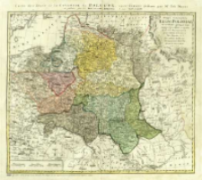
Title: Mappa geographica Regni Poloniae = Carte des etats de la Covronne de Pologne
Subtitle:
Carte des etats de la Covronne de Pologne
Contributor:
Mayer, Tobias (1723–1762) : Oprac.
Publisher:
Luci publicae tradita per Homannianos Heredes
Place of publishing:
Description:
1 mapa : miedzior., akwarela ; 46x53 cm, na ark. 49x54 cm ; Skala [ca 1:2 800 000], podziałka liniowa Milliaria Germanica, 15 ; Podano również południk Paryż : Longituidines Geographicae posita Longit. Parisiorum ; Południk zerowy Ferro ustalony po obliczeniach przez katalogującego ; Data nad górną ramką: MDCCLVIII ; Pod dolną ramką mapy legenda koloru ; La couleur violette margue les pays démembrés de la Pologne en 1772, conformément aux prétensions de trois Puissances voisines ; Imago Poloniae, T. 2, poz. K44/8 ; Polska XVIII w. / B. Krassowski, S. 58, nr. 41 ; Tyt. i autor w jęz. łac. i fr., legenda kolor. w jęz. fr.
Detailed Resource Type:
Format:
Resource Identifier:
Source:
CBGiOŚ. IGiPZ PAN, call no. B.1644/52 ; click here to follow the link
Language:
Rights:
Terms of use:
Digitizing institution:
Institute of Geography and Spatial Organization of the Polish Academy of Sciences
Original in:
Projects co-financed by:
Programme Innovative Economy, 2010-2014, Priority Axis 2. R&D infrastructure ; European Union. European Regional Development Fund
Access:
Object collections:
- Digital Repository of Scientific Institutes > Partners' collections > Institute of Geography and Spatial Organization PAS (IGiPZ PAN) > Library
- Digital Repository of Scientific Institutes > Partners' collections > Institute of Geography and Spatial Organization PAS (IGiPZ PAN) > Library > Maps and atlases
- Digital Repository of Scientific Institutes > Literature > Maps/Atlases
Last modified:
Mar 25, 2021
In our library since:
Nov 22, 2013
Number of object content downloads / hits:
196
All available object's versions:
https://rcin.org.pl./publication/44937
Show description in RDF format:
Show description in RDFa format:
Show description in OAI-PMH format:
| Edition name | Date |
|---|---|
| 1773, Mappa geographica Regni Poloniae = Carte des etats de la Covronne de Pologne | Mar 25, 2021 |
Objects Similar
Mayer, Tobias (1723–1762)
Mayer, Tobias (1723–1762)
Vil'breht, Aleksandr Mihajlovič (1756–1823) Ušakov, K. Rys.
Hutter, Franz Xaver Walch, Johann (1757–1824)
Güssefeld, Franz Ludwig (1744–1808)

 INSTYTUT ARCHEOLOGII I ETNOLOGII POLSKIEJ AKADEMII NAUK
 INSTYTUT BADAŃ LITERACKICH POLSKIEJ AKADEMII NAUK
 INSTYTUT BADAWCZY LEŚNICTWA
 INSTYTUT BIOLOGII DOŚWIADCZALNEJ IM. MARCELEGO NENCKIEGO POLSKIEJ AKADEMII NAUK
 INSTYTUT BIOLOGII SSAKÓW POLSKIEJ AKADEMII NAUK
 INSTYTUT CHEMII FIZYCZNEJ PAN
 INSTYTUT CHEMII ORGANICZNEJ PAN
 INSTYTUT FILOZOFII I SOCJOLOGII PAN
 INSTYTUT GEOGRAFII I PRZESTRZENNEGO ZAGOSPODAROWANIA PAN
 INSTYTUT HISTORII im. TADEUSZA MANTEUFFLA POLSKIEJ AKADEMII NAUK
 INSTYTUT JĘZYKA POLSKIEGO POLSKIEJ AKADEMII NAUK
 INSTYTUT MATEMATYCZNY PAN
 INSTYTUT MEDYCYNY DOŚWIADCZALNEJ I KLINICZNEJ IM.MIROSŁAWA MOSSAKOWSKIEGO POLSKIEJ AKADEMII NAUK
 INSTYTUT PODSTAWOWYCH PROBLEMÓW TECHNIKI PAN
 INSTYTUT SLAWISTYKI PAN
 SIEĆ BADAWCZA ŁUKASIEWICZ - INSTYTUT TECHNOLOGII MATERIAŁÓW ELEKTRONICZNYCH
 MUZEUM I INSTYTUT ZOOLOGII POLSKIEJ AKADEMII NAUK
 INSTYTUT BADAŃ SYSTEMOWYCH PAN
 INSTYTUT BOTANIKI IM. WŁADYSŁAWA SZAFERA POLSKIEJ AKADEMII NAUK


