- About project
- Collections
- Indexes
- Recently viewed
-
RCIN Repositories
-
 INSTYTUT ARCHEOLOGII I ETNOLOGII POLSKIEJ AKADEMII NAUK
-
 INSTYTUT BADAŃ LITERACKICH POLSKIEJ AKADEMII NAUK
-
 INSTYTUT BADAWCZY LEŚNICTWA
-
 INSTYTUT BIOLOGII DOŚWIADCZALNEJ IM. MARCELEGO NENCKIEGO POLSKIEJ AKADEMII NAUK
-
 INSTYTUT BIOLOGII SSAKÓW POLSKIEJ AKADEMII NAUK
-
 INSTYTUT CHEMII FIZYCZNEJ PAN
-
 INSTYTUT CHEMII ORGANICZNEJ PAN
-
 INSTYTUT FILOZOFII I SOCJOLOGII PAN
-
 INSTYTUT GEOGRAFII I PRZESTRZENNEGO ZAGOSPODAROWANIA PAN
-
 INSTYTUT HISTORII im. TADEUSZA MANTEUFFLA POLSKIEJ AKADEMII NAUK
-
 INSTYTUT JĘZYKA POLSKIEGO POLSKIEJ AKADEMII NAUK
-
 INSTYTUT MATEMATYCZNY PAN
-
 INSTYTUT MEDYCYNY DOŚWIADCZALNEJ I KLINICZNEJ IM.MIROSŁAWA MOSSAKOWSKIEGO POLSKIEJ AKADEMII NAUK
-
 INSTYTUT PODSTAWOWYCH PROBLEMÓW TECHNIKI PAN
-
 INSTYTUT SLAWISTYKI PAN
-
 SIEĆ BADAWCZA ŁUKASIEWICZ - INSTYTUT TECHNOLOGII MATERIAŁÓW ELEKTRONICZNYCH
-
 MUZEUM I INSTYTUT ZOOLOGII POLSKIEJ AKADEMII NAUK
-
 INSTYTUT BADAŃ SYSTEMOWYCH PAN
-
 INSTYTUT BOTANIKI IM. WŁADYSŁAWA SZAFERA POLSKIEJ AKADEMII NAUK
-

Object
Available formats:
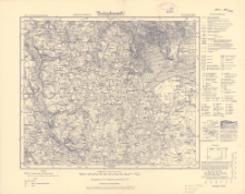
Download allTitle: Karte des Deutschen Reiches, 228. Gorzno - Rypin
Creator:
Niemcy. Reichsamt für Landesaufnahme. Instytucja sprawcza. Wydawca ; Prusy. Landesaufnahme. Instytucja sprawcza
Date issued/created:
Resource type:
Subtitle:
Karte des Deutschen Reiches ; 228
Publisher:
Place of publishing:
Description:
Umdruckausgabe! ; Skala 1:100 000 ; 1 mapa ; 30x35 cm, na arkuszu 37x48 cm ; Data wydania określona na podstawie granic politycznych (na mapie jest już granica Polski) oraz nazwy wydawcy (Reichsamt für Landesaufnahme działał w latach 1920-1945) ; Na dolnym marginesie wykaz jednostek polityczno-administracyjnych i nota: Aufgenommen von der Topogr. Abteilung der Preuß. Landesaufnahme 1909 ; Pod oznaczeniem arkusza zapis: K. d. westl. Rußl. E 29
Type of object:
Relation:
Karte des Deutschen Reiches 1:100 000
Detailed Resource Type:
Format:
Resource Identifier:
Source:
CBGiOŚ. IGiPZ PAN, sygn. C.187/329 ; click here to follow the link
Language:
Coverage:
Rights:
Terms of use:
Digitizing institution:
Instytut Geografii i Przestrzennego Zagospodarowania Polskiej Akademii Nauk
Original in:
Projects co-financed by:
Access:
Object collections:
- Digital Repository of Scientific Institutes > Partners' collections > Institute of Geography and Spatial Organization PAS (IGiPZ PAN) > Library
- Digital Repository of Scientific Institutes > Partners' collections > Institute of Geography and Spatial Organization PAS (IGiPZ PAN) > Library > Maps and atlases
- Digital Repository of Scientific Institutes > Literature > Maps/Atlases
Last modified:
Oct 2, 2020
In our library since:
Dec 30, 2019
Number of object content downloads / hits:
93
All available object's versions:
https://rcin.org.pl./publication/99996
Show description in RDF format:
Show description in RDFa format:
Show description in OAI-PMH format:
| Edition name | Date |
|---|---|
| 228. Gorzno - Rypin, [między 1920 i 1939] | Oct 2, 2020 |
Objects Similar
Prusy. Landesaufnahme. Kartographische Abteilung. Redaktor. Wydawca
Dokaupil, Roman (18...- 19...). Redaktor Straka, J. Redaktor Bloschitz, Rudolf Macoun, V. Redaktor
Rosja. Armiâ. Glavnyj štab. Litografìâ kartografičeskago zavedenìâ. Wydawca
Prusy. Landesaufnahme. Kartographische Abteilung. Instytucja sprawcza Wydawca
Prusy. Landesaufnahme. Kartographische Abteilung. Instytucja sprawcza Wydawca
Prusy. Landesaufnahme. Kartographische Abteilung. Instytucja sprawcza Wydawca
Niemcy. Reichsamt für Landesaufnahme. Wydawca Prusy. Landesaufnahme. Instytucja sprawcza
Prusy. Landesaufnahme. Kartographische Abteilung. Instytucja sprawcza Wydawca


