- About project
- Collections
- Indexes
- Recently viewed
-
RCIN Repositories
-
 INSTYTUT ARCHEOLOGII I ETNOLOGII POLSKIEJ AKADEMII NAUK
-
 INSTYTUT BADAŃ LITERACKICH POLSKIEJ AKADEMII NAUK
-
 INSTYTUT BADAWCZY LEŚNICTWA
-
 INSTYTUT BIOLOGII DOŚWIADCZALNEJ IM. MARCELEGO NENCKIEGO POLSKIEJ AKADEMII NAUK
-
 INSTYTUT BIOLOGII SSAKÓW POLSKIEJ AKADEMII NAUK
-
 INSTYTUT CHEMII FIZYCZNEJ PAN
-
 INSTYTUT CHEMII ORGANICZNEJ PAN
-
 INSTYTUT FILOZOFII I SOCJOLOGII PAN
-
 INSTYTUT GEOGRAFII I PRZESTRZENNEGO ZAGOSPODAROWANIA PAN
-
 INSTYTUT HISTORII im. TADEUSZA MANTEUFFLA POLSKIEJ AKADEMII NAUK
-
 INSTYTUT JĘZYKA POLSKIEGO POLSKIEJ AKADEMII NAUK
-
 INSTYTUT MATEMATYCZNY PAN
-
 INSTYTUT MEDYCYNY DOŚWIADCZALNEJ I KLINICZNEJ IM.MIROSŁAWA MOSSAKOWSKIEGO POLSKIEJ AKADEMII NAUK
-
 INSTYTUT PODSTAWOWYCH PROBLEMÓW TECHNIKI PAN
-
 INSTYTUT SLAWISTYKI PAN
-
 SIEĆ BADAWCZA ŁUKASIEWICZ - INSTYTUT TECHNOLOGII MATERIAŁÓW ELEKTRONICZNYCH
-
 MUZEUM I INSTYTUT ZOOLOGII POLSKIEJ AKADEMII NAUK
-
 INSTYTUT BADAŃ SYSTEMOWYCH PAN
-
 INSTYTUT BOTANIKI IM. WŁADYSŁAWA SZAFERA POLSKIEJ AKADEMII NAUK
-

Object
Available formats:
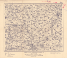
Download allTitle: Karte des Deutschen Reiches, 450. Ohlau
Inny tytuł:
Karte des Deutschen Reiches ; 450
Wydawca:
Miejsce wydania:
Opis:
Scale 1:100 000 ; 1 map ; 30x37 cm, on sheet 36x42 cm ; On the bottom margin: Aufgenommen v. der Topogr. Abteilung der Königl. Pr. Landesaufnahme 1883. Druck 1914 ; In the bottom corner of the map: N.12 ; Prime meridian Ferro
Typ obiektu:
Czasopismo/Seria/cykl:
Karte des Deutschen Reiches 1:100 000
Szczegółowy typ zasobu:
Format:
Identyfikator zasobu:
Źródło:
CBGiOŚ. IGiPZ PAN, call no. C.187/235 ; click here to follow the link
Język:
Zakres:
Prawa:
Zasady wykorzystania:
Digitalizacja:
Institute of Geography and Spatial Organization of the Polish Academy of Sciences
Lokalizacja oryginału:
Dofinansowane ze środków:
Dostęp:
Object collections:
- Repozytorium Cyfrowe Instytutów Naukowych > Kolekcje Partnerów > Instytut Geografii i Przestrzennego Zagospodarowania PAN > Biblioteka Instytutu
- Repozytorium Cyfrowe Instytutów Naukowych > Kolekcje Partnerów > Instytut Geografii i Przestrzennego Zagospodarowania PAN > Biblioteka Instytutu > Mapy i atlasy
- Repozytorium Cyfrowe Instytutów Naukowych > Piśmiennictwo > Mapy/Atlasy
Last modified:
16 gru 2019
In our library since:
16 gru 2019
Number of object content downloads / hits:
87
All available object's versions:
https://rcin.org.pl./publication/98574
Show description in RDF format:
Show description in RDFa format:
Show description in OAI-PMH format:
| Edition name | Date |
|---|---|
| 450. Ohlau, 1914 | 16 gru 2019 |
Objects Similar
Prusy. Landesaufnahme. Kartographische Abteilung. Redaktor
Prusy. Landesaufnahme. Kartographische Abteilung. Redaktor
Prusy. Landesaufnahme. Kartographische Abteilung. Redaktor
Prusy. Landesaufnahme. Kartographische Abteilung. Redaktor
Prusy. Landesaufnahme. Kartographische Abteilung. Redaktor
Prusy. Landesaufnahme. Kartographische Abteilung. Redaktor
Prusy. Landesaufnahme. Kartographische Abteilung. Redaktor
Prusy. Landesaufnahme. Kartographische Abteilung. Redaktor


