- About project
- Collections
- Indexes
- Recently viewed
-
RCIN Repositories
-
 INSTYTUT ARCHEOLOGII I ETNOLOGII POLSKIEJ AKADEMII NAUK
-
 INSTYTUT BADAŃ LITERACKICH POLSKIEJ AKADEMII NAUK
-
 INSTYTUT BADAWCZY LEŚNICTWA
-
 INSTYTUT BIOLOGII DOŚWIADCZALNEJ IM. MARCELEGO NENCKIEGO POLSKIEJ AKADEMII NAUK
-
 INSTYTUT BIOLOGII SSAKÓW POLSKIEJ AKADEMII NAUK
-
 INSTYTUT CHEMII FIZYCZNEJ PAN
-
 INSTYTUT CHEMII ORGANICZNEJ PAN
-
 INSTYTUT FILOZOFII I SOCJOLOGII PAN
-
 INSTYTUT GEOGRAFII I PRZESTRZENNEGO ZAGOSPODAROWANIA PAN
-
 INSTYTUT HISTORII im. TADEUSZA MANTEUFFLA POLSKIEJ AKADEMII NAUK
-
 INSTYTUT JĘZYKA POLSKIEGO POLSKIEJ AKADEMII NAUK
-
 INSTYTUT MATEMATYCZNY PAN
-
 INSTYTUT MEDYCYNY DOŚWIADCZALNEJ I KLINICZNEJ IM.MIROSŁAWA MOSSAKOWSKIEGO POLSKIEJ AKADEMII NAUK
-
 INSTYTUT PODSTAWOWYCH PROBLEMÓW TECHNIKI PAN
-
 INSTYTUT SLAWISTYKI PAN
-
 SIEĆ BADAWCZA ŁUKASIEWICZ - INSTYTUT TECHNOLOGII MATERIAŁÓW ELEKTRONICZNYCH
-
 MUZEUM I INSTYTUT ZOOLOGII POLSKIEJ AKADEMII NAUK
-
 INSTYTUT BADAŃ SYSTEMOWYCH PAN
-
 INSTYTUT BOTANIKI IM. WŁADYSŁAWA SZAFERA POLSKIEJ AKADEMII NAUK
-
- Search in all Repository
- Literature and maps
- Archeology
- Mills database
- Natural sciences
Advanced search
Advanced search
Advanced search
Advanced search
Advanced search

Object
Available formats:
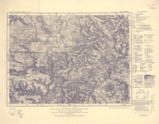
Download allTitle: Karte des Deutschen Reiches, 645. Tuttlingen
Subtitle:
Karte des Deutschen Reiches ; 645
Publisher:
Place of publishing:
Description:
Ausgabe 1950 ; Skala 1:100 000 ; 1 mapa ; 30x39 cm, na arkuszu 40x50 cm ; Na dolnym marginesie: Ausgabe 1950 von der Hauptvermessungsabteilung Württemberg / Hohenzollern- Baden Reutlingen Letze Nachträge 1947
Type of object:
Relation:
Karte des Deutschen Reiches 1:100 000
Detailed Resource Type:
Format:
Resource Identifier:
Source:
CBGiOŚ. IGiPZ PAN, sygn. C.187/104 ; click here to follow the link
Language:
Coverage:
Rights:
Terms of use:
Digitizing institution:
Instytut Geografii i Przestrzennego Zagospodarowania Polskiej Akademii Nauk
Original in:
Projects co-financed by:
Access:
Object collections:
- Digital Repository of Scientific Institutes > Partners' collections > Institute of Geography and Spatial Organization PAS (IGiPZ PAN) > Library
- Digital Repository of Scientific Institutes > Partners' collections > Institute of Geography and Spatial Organization PAS (IGiPZ PAN) > Library > Maps and atlases
- Digital Repository of Scientific Institutes > Literature > Maps/Atlases
Last modified:
Oct 2, 2020
In our library since:
Dec 17, 2019
Number of object content downloads / hits:
80
All available object's versions:
https://rcin.org.pl./publication/97033
Show description in RDF format:
Show description in RDFa format:
Show description in OAI-PMH format:
| Edition name | Date |
|---|---|
| 645. Tuttlingen, 1950 | Oct 2, 2020 |
Objects Similar
Niemcy. Reichsamt für Landesaufnahme. Wydawca Prusy. Landesaufnahme. Redaktor
Niemcy. Reichsamt für Landesaufnahme. Redaktor Prusy. Landesaufnahme. Redaktor Hesja (Niemcy ; land). Landesvermessungsamt. Redaktor. Wydawca
Niemcy. Reichsamt für Landesaufnahme. Redaktor Prusy. Landesaufnahme. Redaktor Hesja (Niemcy ; land). Landesvermessungsamt. Redaktor. Wydawca
Prusy. Landesaufnahme. Kartographische Abteilung. Redaktor
Prusy. Landesaufnahme. Redaktor Badenia-Wirtemberia (Niemcy ; land). Landesvermessungsamt. Wydawca
Prusy. Landesaufnahme. Redaktor Niemcy. Reichsamt für Landesaufnahme. Wydawca
Niemcy. Reichsamt für Landesaufnahme. Wydawca Prusy. Landesaufnahme. Redaktor
Niemcy. Reichsamt für Landesaufnahme. Wydawca Prusy. Landesaufnahme. Redaktor


