- O repozytorium
- Kolekcje
- Indeksy
- Historia przeglądania
-
Repozytoria RCIN
-
 INSTYTUT ARCHEOLOGII I ETNOLOGII POLSKIEJ AKADEMII NAUK
-
 INSTYTUT BADAŃ LITERACKICH POLSKIEJ AKADEMII NAUK
-
 INSTYTUT BADAWCZY LEŚNICTWA
-
 INSTYTUT BIOLOGII DOŚWIADCZALNEJ IM. MARCELEGO NENCKIEGO POLSKIEJ AKADEMII NAUK
-
 INSTYTUT BIOLOGII SSAKÓW POLSKIEJ AKADEMII NAUK
-
 INSTYTUT CHEMII FIZYCZNEJ PAN
-
 INSTYTUT CHEMII ORGANICZNEJ PAN
-
 INSTYTUT FILOZOFII I SOCJOLOGII PAN
-
 INSTYTUT GEOGRAFII I PRZESTRZENNEGO ZAGOSPODAROWANIA PAN
-
 INSTYTUT HISTORII im. TADEUSZA MANTEUFFLA POLSKIEJ AKADEMII NAUK
-
 INSTYTUT JĘZYKA POLSKIEGO POLSKIEJ AKADEMII NAUK
-
 INSTYTUT MATEMATYCZNY PAN
-
 INSTYTUT MEDYCYNY DOŚWIADCZALNEJ I KLINICZNEJ IM.MIROSŁAWA MOSSAKOWSKIEGO POLSKIEJ AKADEMII NAUK
-
 INSTYTUT PODSTAWOWYCH PROBLEMÓW TECHNIKI PAN
-
 INSTYTUT SLAWISTYKI PAN
-
 SIEĆ BADAWCZA ŁUKASIEWICZ - INSTYTUT TECHNOLOGII MATERIAŁÓW ELEKTRONICZNYCH
-
 MUZEUM I INSTYTUT ZOOLOGII POLSKIEJ AKADEMII NAUK
-
 INSTYTUT BADAŃ SYSTEMOWYCH PAN
-
 INSTYTUT BOTANIKI IM. WŁADYSŁAWA SZAFERA POLSKIEJ AKADEMII NAUK
-
- Wyszukaj w całym Repozytorium
- Piśmiennictwo i mapy
- Archeologia
- Baza Młynów
- Nauki przyrodnicze
Wyszukiwanie zaawansowane
Wyszukiwanie zaawansowane
Wyszukiwanie zaawansowane
Wyszukiwanie zaawansowane
Wyszukiwanie zaawansowane

Obiekt
Dostępne formaty:
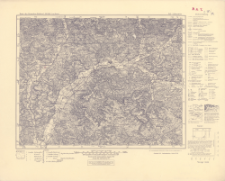
Pobierz wszystkieTytuł: Karte des Deutschen Reiches 1:100 000, 512. Lichtenfels
Twórca:
Niemcy. Reichsamt für Landesaufnahme. Wydawca ; Bawaria (Niemcy ; land). Topographisches Bureau. Redaktor
Data wydania/powstania:
Typ zasobu:
Inny tytuł:
Karte des Deutschen Reiches 1:100 000 ; 512
Wydawca:
Miejsce wydania:
Opis:
Ausgabe 1943 ; Scale 1:100 000 ; 1 map ; 30x38 cm, on sheet 40x50 cm ; On the bottom margin: Berichtigt 1922 Letze Nachträge 1940. Neudruck 1951, Landesaufnahme, Berlin SW 68
Typ obiektu:
Czasopismo/Seria/cykl:
Karte des Deutschen Reiches 1:100 000
Szczegółowy typ zasobu:
Format:
Identyfikator zasobu:
Źródło:
CBGiOŚ. IGiPZ PAN, call no. C.187/72 ; kliknij tutaj, żeby przejść
Język:
Zakres:
Prawa:
Zasady wykorzystania:
Digitalizacja:
Institute of Geography and Spatial Organization of the Polish Academy of Sciences
Lokalizacja oryginału:
Dofinansowane ze środków:
Dostęp:
Kolekcje, do których przypisany jest obiekt:
- Repozytorium Cyfrowe Instytutów Naukowych > Kolekcje Partnerów > Instytut Geografii i Przestrzennego Zagospodarowania PAN > Biblioteka Instytutu
- Repozytorium Cyfrowe Instytutów Naukowych > Kolekcje Partnerów > Instytut Geografii i Przestrzennego Zagospodarowania PAN > Biblioteka Instytutu > Mapy i atlasy
- Repozytorium Cyfrowe Instytutów Naukowych > Piśmiennictwo > Mapy/Atlasy
Data ostatniej modyfikacji:
2 paź 2020
Data dodania obiektu:
18 gru 2019
Liczba pobrań / odtworzeń:
83
Wszystkie dostępne wersje tego obiektu:
https://rcin.org.pl./publication/96816
Wyświetl opis w formacie RDF:
Wyświetl opis w formacie RDFa:
Wyświetl opis w formacie OAI-PMH:
| Nazwa wydania | Data |
|---|---|
| 512. Lichtenfels, 1951 | 2 paź 2020 |
Obiekty Podobne
Bawaria (Niemcy ; land). Topographisches Bureau. Redaktor Niemcy. Reichsamt für Landesaufnahme. Wydawca
Bawaria (Niemcy ; land). Topographisches Bureau. Redaktor Bawaria (Niemcy ; land). Bayerisches Landesvermessungsamt. Topographische Zweigstelle. Wydawca
Bawaria (Niemcy ; land). Topographisches Bureau. Redaktor Bawaria (Niemcy ; land). Bayerisches Landesvermessungsamt. Topographische Zweigstelle. Wydawca
Bawaria (Niemcy ; land). Topographisches Bureau. Redaktor Niemcy. Hauptvermessungsabteilung XIII. Wydawca Prusy. Landesaufnahme. Wydawca
Bawaria (Niemcy ; land). Topographisches Bureau. Redaktor Wirtembergia (Niemcy). Ministerium des Innern. Hauptvermessungsabteilung XII. Wydawca Prusy. Landesaufnahme. Wydawca
Prusy. Landesaufnahme. Redaktor Niemcy. Reichsamt für Landesaufnahme. Wydawca
Niemcy. Reichsamt für Landesaufnahme. Wydawca Prusy. Landesaufnahme. Redaktor
Niemcy. Reichsamt für Landesaufnahme. Wydawca Prusy. Landesaufnahme. Instytucja sprawcza


