- Wyszukaj w całym Repozytorium
- Piśmiennictwo i mapy
- Archeologia
- Baza Młynów
- Nauki przyrodnicze
Wyszukiwanie zaawansowane
Wyszukiwanie zaawansowane
Wyszukiwanie zaawansowane
Wyszukiwanie zaawansowane
Wyszukiwanie zaawansowane

Obiekt
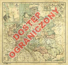
Tytuł: Polska w XVII w. : granice z r. 1619 z uwzględnieniem późniejszych zmian oraz miejsc historycznych do końca XVII w. : podziałka 1:6 000 000
Współtwórca:
Książnica-Atlas, Zjednoczone Zakłady Kartograficzne i Wydawnicze Towarzystwa Nauczycieli Szkół Średnich i Wyższych ; Instytut Kartograficzny im. Eugeniusza Romera
Wydawca:
Nakład i druk Ski. Akc. Książnica-Atlas Zjednoczone Zakłady Kartograficzne i Wydawnicze T. N. S. W.
Miejsce wydania:
Opis:
Skala 1:6 000 000 ; 1 mapa : kolor. ; 27x28 cm, na ark. 32x33 cm ; Tyt. z mapy ; Mapy poboczne: Bitwa pod Warszawą d. 28, 29 i 30 lipca 1656 r.: 1:47 000 ; Bitwa pod Kirchholmem d. 27 września 1605 r. : 1:100 000 ; Bitwa pod Chocimiem d. 11 list. 1675 : 1:200 000 ; Bitwa pod Wiedniem d. 12 września ; Rzeźba terenu przedst. za pomocą cieniowania ; Autor wg: Atlasy i mapy Książnicy-Atlas z wyłączeniem prac Eugeniusza Romera : katalog / Barbara Przyłuska, Zbigniew Kołek. - Warszawa, 2007. s. 37, poz. B48
Szczegółowy typ zasobu:
Format:
Identyfikator zasobu:
Źródło:
CBGiOŚ. IGiPZ PAN, sygn. D.6464 [m.hist.30] ; kliknij tutaj, żeby przejść
Język:
Prawa:
Zasady wykorzystania:
Digitalizacja:
Instytut Geografii i Przestrzennego Zagospodarowania Polskiej Akademii Nauk
Lokalizacja oryginału:
Dofinansowane ze środków:
Program Operacyjny Innowacyjna Gospodarka, lata 2010-2014, Priorytet 2. Infrastruktura strefy B + R ; Unia Europejska. Europejski Fundusz Rozwoju Regionalnego
Dostęp:
Kolekcje, do których przypisany jest obiekt:
- Repozytorium Cyfrowe Instytutów Naukowych > Kolekcje Partnerów > Instytut Geografii i Przestrzennego Zagospodarowania PAN > Biblioteka Instytutu
- Repozytorium Cyfrowe Instytutów Naukowych > Kolekcje Partnerów > Instytut Geografii i Przestrzennego Zagospodarowania PAN > Biblioteka Instytutu > Mapy i atlasy
- Repozytorium Cyfrowe Instytutów Naukowych > Piśmiennictwo > Mapy/Atlasy
Data ostatniej modyfikacji:
12 paź 2020
Data dodania obiektu:
13 cze 2013
Liczba pobrań / odtworzeń:
458
Wszystkie dostępne wersje tego obiektu:
https://rcin.org.pl./publication/41345
Wyświetl opis w formacie RDF:
Wyświetl opis w formacie RDFa:
Wyświetl opis w formacie OAI-PMH:
Obiekty Podobne
Semkowicz, Władysław Aleksander (1878–1949)
Semkowicz, Władysław Aleksander (1878–1949)
Semkowicz, Władysław Aleksander (1878–1949)
Semkowicz, Władysław Aleksander (1878–1949)
Semkowicz, Władysław Aleksander (1878–1949)
Cieszyńska, Beata Żukowska, Maria Helena Giebułtowski, Jerzy

 INSTYTUT ARCHEOLOGII I ETNOLOGII POLSKIEJ AKADEMII NAUK
 INSTYTUT BADAŃ LITERACKICH POLSKIEJ AKADEMII NAUK
 INSTYTUT BADAWCZY LEŚNICTWA
 INSTYTUT BIOLOGII DOŚWIADCZALNEJ IM. MARCELEGO NENCKIEGO POLSKIEJ AKADEMII NAUK
 INSTYTUT BIOLOGII SSAKÓW POLSKIEJ AKADEMII NAUK
 INSTYTUT CHEMII FIZYCZNEJ PAN
 INSTYTUT CHEMII ORGANICZNEJ PAN
 INSTYTUT FILOZOFII I SOCJOLOGII PAN
 INSTYTUT GEOGRAFII I PRZESTRZENNEGO ZAGOSPODAROWANIA PAN
 INSTYTUT HISTORII im. TADEUSZA MANTEUFFLA POLSKIEJ AKADEMII NAUK
 INSTYTUT JĘZYKA POLSKIEGO POLSKIEJ AKADEMII NAUK
 INSTYTUT MATEMATYCZNY PAN
 INSTYTUT MEDYCYNY DOŚWIADCZALNEJ I KLINICZNEJ IM.MIROSŁAWA MOSSAKOWSKIEGO POLSKIEJ AKADEMII NAUK
 INSTYTUT PODSTAWOWYCH PROBLEMÓW TECHNIKI PAN
 INSTYTUT SLAWISTYKI PAN
 SIEĆ BADAWCZA ŁUKASIEWICZ - INSTYTUT TECHNOLOGII MATERIAŁÓW ELEKTRONICZNYCH
 MUZEUM I INSTYTUT ZOOLOGII POLSKIEJ AKADEMII NAUK
 INSTYTUT BADAŃ SYSTEMOWYCH PAN
 INSTYTUT BOTANIKI IM. WŁADYSŁAWA SZAFERA POLSKIEJ AKADEMII NAUK


