- O repozytorium
- Kolekcje
- Indeksy
- Historia przeglądania
-
Repozytoria RCIN
-
 INSTYTUT ARCHEOLOGII I ETNOLOGII POLSKIEJ AKADEMII NAUK
-
 INSTYTUT BADAŃ LITERACKICH POLSKIEJ AKADEMII NAUK
-
 INSTYTUT BADAWCZY LEŚNICTWA
-
 INSTYTUT BIOLOGII DOŚWIADCZALNEJ IM. MARCELEGO NENCKIEGO POLSKIEJ AKADEMII NAUK
-
 INSTYTUT BIOLOGII SSAKÓW POLSKIEJ AKADEMII NAUK
-
 INSTYTUT CHEMII FIZYCZNEJ PAN
-
 INSTYTUT CHEMII ORGANICZNEJ PAN
-
 INSTYTUT FILOZOFII I SOCJOLOGII PAN
-
 INSTYTUT GEOGRAFII I PRZESTRZENNEGO ZAGOSPODAROWANIA PAN
-
 INSTYTUT HISTORII im. TADEUSZA MANTEUFFLA POLSKIEJ AKADEMII NAUK
-
 INSTYTUT JĘZYKA POLSKIEGO POLSKIEJ AKADEMII NAUK
-
 INSTYTUT MATEMATYCZNY PAN
-
 INSTYTUT MEDYCYNY DOŚWIADCZALNEJ I KLINICZNEJ IM.MIROSŁAWA MOSSAKOWSKIEGO POLSKIEJ AKADEMII NAUK
-
 INSTYTUT PODSTAWOWYCH PROBLEMÓW TECHNIKI PAN
-
 INSTYTUT SLAWISTYKI PAN
-
 SIEĆ BADAWCZA ŁUKASIEWICZ - INSTYTUT TECHNOLOGII MATERIAŁÓW ELEKTRONICZNYCH
-
 MUZEUM I INSTYTUT ZOOLOGII POLSKIEJ AKADEMII NAUK
-
 INSTYTUT BADAŃ SYSTEMOWYCH PAN
-
 INSTYTUT BOTANIKI IM. WŁADYSŁAWA SZAFERA POLSKIEJ AKADEMII NAUK
-

Obiekt
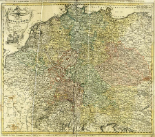
Tytuł: Charte welche das Deutsche Reich nach seinen Kreisen und Staaten vorstellet
Inny tytuł:
L'Allemagne, distinguée en ses Cercles et subdivisée en ses Etats
Współtwórca:
Wydawca:
bey den Homannischen Erben mit Röm. Kaiserl. allergnaædigster Freyheit
Miejsce wydania:
Opis:
Skala [ca 1:2 500 000] ; 1 mapa : miedzior., kolor. ręcznie ; 46x53 cm ; Brak siatki kartograficzej ; Po tyt. nad. ramką: contenant son Etendue presente, rectifiée & methodiquement enluminée suivant les Elements de Geographie de Mr. Schatz ; Data wg. BVB. ; Tyt. w jęz. niem. i fr.
Szczegółowy typ zasobu:
Format:
File size 3,6 MB ; image/x.djvu
Identyfikator zasobu:
Źródło:
CBGiOŚ. IGiPZ PAN, call no. PTG B.1619/11 ; kliknij tutaj, żeby przejść
Język:
Prawa:
Zasady wykorzystania:
Digitalizacja:
Institute of Geography and Spatial Organization of the Polish Academy of Sciences
Lokalizacja oryginału:
Dofinansowane ze środków:
Programme Innovative Economy, 2010-2014, Priority Axis 2. R&D infrastructure ; European Union. European Regional Development Fund
Dostęp:
Kolekcje, do których przypisany jest obiekt:
- Repozytorium Cyfrowe Instytutów Naukowych > Kolekcje Partnerów > Instytut Geografii i Przestrzennego Zagospodarowania PAN > Biblioteka Instytutu
- Repozytorium Cyfrowe Instytutów Naukowych > Kolekcje Partnerów > Instytut Geografii i Przestrzennego Zagospodarowania PAN > Biblioteka Instytutu > Mapy i atlasy
- Repozytorium Cyfrowe Instytutów Naukowych > Kolekcje Partnerów > Instytut Geografii i Przestrzennego Zagospodarowania PAN > Biblioteka Instytutu > Wybrane księgozbiory > Księgozbiór Polskiego Towarzystwa Geograficznego
- Repozytorium Cyfrowe Instytutów Naukowych > Piśmiennictwo > Mapy/Atlasy
Data ostatniej modyfikacji:
2 paź 2020
Data dodania obiektu:
31 sie 2012
Liczba pobrań / odtworzeń:
259
Wszystkie dostępne wersje tego obiektu:
https://rcin.org.pl./publication/26094
Wyświetl opis w formacie RDF:
Wyświetl opis w formacie RDFa:
Wyświetl opis w formacie OAI-PMH:
Obiekty Podobne
Homann, Johann Baptist (1664–1724)
Homann, Johann Baptist (1664–1724)
Homann, Johann Baptist (1664–1724)
Homann, Johann Baptist (1664–1724)
Homann, Johann Baptist (1664–1724)
Homann, Johann Baptist (1664–1724)
Homann, Johann Baptist (1664–1724)
Homann, Johann Baptist (1664–1724)


