- About project
- Collections
- Indexes
- Recently viewed
-
RCIN Repositories
-
 INSTYTUT ARCHEOLOGII I ETNOLOGII POLSKIEJ AKADEMII NAUK
-
 INSTYTUT BADAŃ LITERACKICH POLSKIEJ AKADEMII NAUK
-
 INSTYTUT BADAWCZY LEŚNICTWA
-
 INSTYTUT BIOLOGII DOŚWIADCZALNEJ IM. MARCELEGO NENCKIEGO POLSKIEJ AKADEMII NAUK
-
 INSTYTUT BIOLOGII SSAKÓW POLSKIEJ AKADEMII NAUK
-
 INSTYTUT CHEMII FIZYCZNEJ PAN
-
 INSTYTUT CHEMII ORGANICZNEJ PAN
-
 INSTYTUT FILOZOFII I SOCJOLOGII PAN
-
 INSTYTUT GEOGRAFII I PRZESTRZENNEGO ZAGOSPODAROWANIA PAN
-
 INSTYTUT HISTORII im. TADEUSZA MANTEUFFLA POLSKIEJ AKADEMII NAUK
-
 INSTYTUT JĘZYKA POLSKIEGO POLSKIEJ AKADEMII NAUK
-
 INSTYTUT MATEMATYCZNY PAN
-
 INSTYTUT MEDYCYNY DOŚWIADCZALNEJ I KLINICZNEJ IM.MIROSŁAWA MOSSAKOWSKIEGO POLSKIEJ AKADEMII NAUK
-
 INSTYTUT PODSTAWOWYCH PROBLEMÓW TECHNIKI PAN
-
 INSTYTUT SLAWISTYKI PAN
-
 SIEĆ BADAWCZA ŁUKASIEWICZ - INSTYTUT TECHNOLOGII MATERIAŁÓW ELEKTRONICZNYCH
-
 MUZEUM I INSTYTUT ZOOLOGII POLSKIEJ AKADEMII NAUK
-
 INSTYTUT BADAŃ SYSTEMOWYCH PAN
-
 INSTYTUT BOTANIKI IM. WŁADYSŁAWA SZAFERA POLSKIEJ AKADEMII NAUK
-
- Search in all Repository
- Literature and maps
- Archeology
- Mills database
- Natural sciences
Advanced search
Advanced search
Advanced search
Advanced search
Advanced search

Object
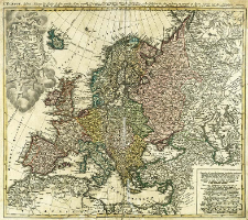
Title: Europa secundum legitimas Projectonis Stereographicae regulas et juxta recentissimas observationes aeque ac relationes adhibitis quoque veterum monumentorum subsidiis descripta et in partes suas methodicas X divisa
Subtitle:
Europe dessinée Suivant les Regles plus precises d'une nouvelle Projection Stereographique...
Contributor:
Publisher:
Edita Curis Homannianorum Heredum
Place of publishing:
Description:
Skala [ca 1:11 300 000] ; 1 mapa : miedzior., kolor. ręcznie ; 46x52 cm ; Miejsce wyd. wg. wydawcy ; W kartuszu data: a MDCCXXXXIII [...] Demio emendata 1789 ; Mapa pochodzi z atlasu: Atlas maior variis auctoribus, Homanno, Valck et cetera ; Tytuł w jęz. łac. i fr.
Detailed Resource Type:
Format:
File size 3,5 MB ; image/x.djvu
Resource Identifier:
Source:
CBGiOŚ. IGiPZ PAN, call no. PTG B.1619/2 ; click here to follow the link
Language:
Rights:
Terms of use:
Digitizing institution:
Institute of Geography and Spatial Organization of the Polish Academy of Sciences
Original in:
Projects co-financed by:
Programme Innovative Economy, 2010-2014, Priority Axis 2. R&D infrastructure ; European Union. European Regional Development Fund
Access:
Object collections:
- Digital Repository of Scientific Institutes > Partners' collections > Institute of Geography and Spatial Organization PAS (IGiPZ PAN) > Library
- Digital Repository of Scientific Institutes > Partners' collections > Institute of Geography and Spatial Organization PAS (IGiPZ PAN) > Library > Maps and atlases
- Digital Repository of Scientific Institutes > Partners' collections > Institute of Geography and Spatial Organization PAS (IGiPZ PAN) > Library > Selected collections > Polish Geographical Society Collection
- Digital Repository of Scientific Institutes > Literature > Maps/Atlases
Last modified:
Oct 2, 2020
In our library since:
Aug 31, 2012
Number of object content downloads / hits:
185
All available object's versions:
https://rcin.org.pl./publication/25632
Show description in RDF format:
Show description in RDFa format:
Show description in OAI-PMH format:
Objects Similar
Hase, Johann Matthias (1684–1742)
Hase, Johann Matthias (1684–1742)
Hase, Johann Matthias (1684–1742)
Hase, Johann Matthias (1684–1742) Böhme, August Gottlob (1719–1797)
Hase, Johann Matthias (1684–1742) Dorn, Sebastian (1705–1778)
Hase, Johann Matthias (1684–1742) Lowitz, Georg Moriz (1722–1774)
Hase, Johann Matthias (1684–1742) Böhme, August Gottlob (1719–1797)
Martinoli, A. Preatoni, D. G. Tosi, G.


