- Wyszukaj w całym Repozytorium
- Piśmiennictwo i mapy
- Archeologia
- Baza Młynów
- Nauki przyrodnicze
Wyszukiwanie zaawansowane
Wyszukiwanie zaawansowane
Wyszukiwanie zaawansowane
Wyszukiwanie zaawansowane
Wyszukiwanie zaawansowane

Obiekt
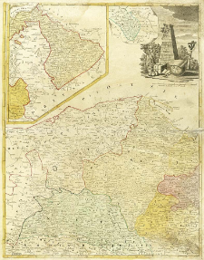
Tytuł: Borussiae Occiden-Talis Tabula
Inny tytuł:
Współtwórca:
Wydawca:
Impensis Homannianorum Haeredum
Miejsce wydania:
Opis:
1 mapa : miedzior., kolor. ręcznie ; 58x45 cm, na ark. 64x52 cm ; Skala [ca 1:600 000], podziałka liniowa: Milliaria Geograph. 15 in 1mo Gradu ; Editio emendatior ; Brak objaśnienia znaków. Na mapie naniesiona siatka kartogr ; Południk Ferro: określony po obliczeniu współrzędnych przez katalogującego ; Mapa wydawana w sztucznym atlasie spadkobierców Homanna: Atlas geographicus maior (...). - Norimbergae, [ca 1780] ; Na ark. po lewej stronie kartusza mapy poboczne: południowa część Okręgu Noteci na zwoju 9x12 cm, w skali ca 1:1 000 000 ; mapa Warmii w ramce o kształtach nieregularnych 28x24 cm., w skali ca 1:600 000, (przedłużenie mapy głównej w kierunku wschodnim) ; Cyt. w: Imago Poloniae, T. 2, s. 215, poz. K101/5 ; Cyt. w: Polska w dawnej kartografii : historyczne ziemie na mapach do początku XIX wieku w zbiorach Ossolineum / Mariusz Dworsatschek, s. 121, poz. 169 ; Miejsce wyd. wg: Katalog atlasów Biblioteki Uniwersyteckiej w Wilnie / M. Dzikowski, s. 366-367, poz. 290
Szczegółowy typ zasobu:
Format:
Rozmiar pliku 2,7 MB ; image/x.djvu
Identyfikator zasobu:
Źródło:
CBGiOŚ. IGiPZ PAN, sygn. PTG B.1619/21 ; kliknij tutaj, żeby przejść
Język:
Prawa:
Zasady wykorzystania:
Digitalizacja:
Instytut Geografii i Przestrzennego Zagospodarowania Polskiej Akademii Nauk
Lokalizacja oryginału:
Dofinansowane ze środków:
Program Operacyjny Innowacyjna Gospodarka, lata 2010-2014, Priorytet 2. Infrastruktura strefy B + R ; Unia Europejska. Europejski Fundusz Rozwoju Regionalnego
Dostęp:
Kolekcje, do których przypisany jest obiekt:
- Repozytorium Cyfrowe Instytutów Naukowych > Kolekcje Partnerów > Instytut Geografii i Przestrzennego Zagospodarowania PAN > Biblioteka Instytutu
- Repozytorium Cyfrowe Instytutów Naukowych > Kolekcje Partnerów > Instytut Geografii i Przestrzennego Zagospodarowania PAN > Biblioteka Instytutu > Mapy i atlasy
- Repozytorium Cyfrowe Instytutów Naukowych > Kolekcje Partnerów > Instytut Geografii i Przestrzennego Zagospodarowania PAN > Biblioteka Instytutu > Wybrane księgozbiory > Księgozbiór Polskiego Towarzystwa Geograficznego
- Repozytorium Cyfrowe Instytutów Naukowych > Piśmiennictwo > Mapy/Atlasy
Data ostatniej modyfikacji:
2 paź 2020
Data dodania obiektu:
31 sie 2012
Liczba pobrań / odtworzeń:
188
Wszystkie dostępne wersje tego obiektu:
https://rcin.org.pl./publication/26162
Wyświetl opis w formacie RDF:
Wyświetl opis w formacie RDFa:
Wyświetl opis w formacie OAI-PMH:
| Nazwa wydania | Data |
|---|---|
| Güssefeld, Franz Ludwig (1744-1808), 1780, Borussiae Occiden-Talis Tabula | 2 paź 2020 |
Obiekty Podobne
Güssefeld, Franz Ludwig (1744–1808)
Güssefeld, Franz Ludwig (1744–1808)
Güssefeld, Franz Ludwig (1744–1808)
Güssefeld, Franz Ludwig (1744–1808)
Güssefeld, Franz Ludwig (1744–1808)

 INSTYTUT ARCHEOLOGII I ETNOLOGII POLSKIEJ AKADEMII NAUK
 INSTYTUT BADAŃ LITERACKICH POLSKIEJ AKADEMII NAUK
 INSTYTUT BADAWCZY LEŚNICTWA
 INSTYTUT BIOLOGII DOŚWIADCZALNEJ IM. MARCELEGO NENCKIEGO POLSKIEJ AKADEMII NAUK
 INSTYTUT BIOLOGII SSAKÓW POLSKIEJ AKADEMII NAUK
 INSTYTUT CHEMII FIZYCZNEJ PAN
 INSTYTUT CHEMII ORGANICZNEJ PAN
 INSTYTUT FILOZOFII I SOCJOLOGII PAN
 INSTYTUT GEOGRAFII I PRZESTRZENNEGO ZAGOSPODAROWANIA PAN
 INSTYTUT HISTORII im. TADEUSZA MANTEUFFLA POLSKIEJ AKADEMII NAUK
 INSTYTUT JĘZYKA POLSKIEGO POLSKIEJ AKADEMII NAUK
 INSTYTUT MATEMATYCZNY PAN
 INSTYTUT MEDYCYNY DOŚWIADCZALNEJ I KLINICZNEJ IM.MIROSŁAWA MOSSAKOWSKIEGO POLSKIEJ AKADEMII NAUK
 INSTYTUT PODSTAWOWYCH PROBLEMÓW TECHNIKI PAN
 INSTYTUT SLAWISTYKI PAN
 SIEĆ BADAWCZA ŁUKASIEWICZ - INSTYTUT TECHNOLOGII MATERIAŁÓW ELEKTRONICZNYCH
 MUZEUM I INSTYTUT ZOOLOGII POLSKIEJ AKADEMII NAUK
 INSTYTUT BADAŃ SYSTEMOWYCH PAN
 INSTYTUT BOTANIKI IM. WŁADYSŁAWA SZAFERA POLSKIEJ AKADEMII NAUK


