- About project
- Collections
- Indexes
- Recently viewed
-
RCIN Repositories
-
 INSTYTUT ARCHEOLOGII I ETNOLOGII POLSKIEJ AKADEMII NAUK
-
 INSTYTUT BADAŃ LITERACKICH POLSKIEJ AKADEMII NAUK
-
 INSTYTUT BADAWCZY LEŚNICTWA
-
 INSTYTUT BIOLOGII DOŚWIADCZALNEJ IM. MARCELEGO NENCKIEGO POLSKIEJ AKADEMII NAUK
-
 INSTYTUT BIOLOGII SSAKÓW POLSKIEJ AKADEMII NAUK
-
 INSTYTUT CHEMII FIZYCZNEJ PAN
-
 INSTYTUT CHEMII ORGANICZNEJ PAN
-
 INSTYTUT FILOZOFII I SOCJOLOGII PAN
-
 INSTYTUT GEOGRAFII I PRZESTRZENNEGO ZAGOSPODAROWANIA PAN
-
 INSTYTUT HISTORII im. TADEUSZA MANTEUFFLA POLSKIEJ AKADEMII NAUK
-
 INSTYTUT JĘZYKA POLSKIEGO POLSKIEJ AKADEMII NAUK
-
 INSTYTUT MATEMATYCZNY PAN
-
 INSTYTUT MEDYCYNY DOŚWIADCZALNEJ I KLINICZNEJ IM.MIROSŁAWA MOSSAKOWSKIEGO POLSKIEJ AKADEMII NAUK
-
 INSTYTUT PODSTAWOWYCH PROBLEMÓW TECHNIKI PAN
-
 INSTYTUT SLAWISTYKI PAN
-
 SIEĆ BADAWCZA ŁUKASIEWICZ - INSTYTUT TECHNOLOGII MATERIAŁÓW ELEKTRONICZNYCH
-
 MUZEUM I INSTYTUT ZOOLOGII POLSKIEJ AKADEMII NAUK
-
 INSTYTUT BADAŃ SYSTEMOWYCH PAN
-
 INSTYTUT BOTANIKI IM. WŁADYSŁAWA SZAFERA POLSKIEJ AKADEMII NAUK
-
- Search in all Repository
- Literature and maps
- Archeology
- Mills database
- Natural sciences
Advanced search
Advanced search
Advanced search
Advanced search
Advanced search

Object
Available formats:
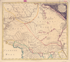
Download allTitle: No. 11, Territorium Pontum Evxinum et Mare Caspium Interiacens Cubaniae et Georgiae Delineationem Geographicam reliquamque Partem Fluvii Volgae eiusque Ostium exhibens
Subtitle:
Contributor:
Imperatorskaâ akademiâ nauk (Petersburg)
Publisher:
Entworffen bey der Kayserl. Academie der Wissenschaften
Place of publishing:
Description:
Skala [ca 1:1 500 000] ; 1 mapa : miedzior., ręcznie kolor. ; 48x55 cm ; Mapa z: Atlas Russicus. - St. Petersburg, 1745 ; Tyt. mapy w jęz. łac., treść mapy w jęz. ros. pisana alfabetem łacińskim
Relation:
Detailed Resource Type:
Resource Identifier:
Source:
CBGiOŚ. IGiPZ PAN, sygn. B.7153 [8]
Language:
Rights:
Terms of use:
Digitizing institution:
Instytut Geografii i Przestrzennego Zagospodarowania Polskiej Akademii Nauk
Original in:
Projects co-financed by:
Access:
Object collections:
- Digital Repository of Scientific Institutes > Partners' collections > Institute of Geography and Spatial Organization PAS (IGiPZ PAN) > Library
- Digital Repository of Scientific Institutes > Partners' collections > Institute of Geography and Spatial Organization PAS (IGiPZ PAN) > Library > Maps and atlases
- Digital Repository of Scientific Institutes > Literature > Maps/Atlases
Last modified:
Mar 15, 2021
In our library since:
Mar 15, 2021
Number of object content downloads / hits:
36
All available object's versions:
https://rcin.org.pl./publication/72220
Show description in RDF format:
Show description in RDFa format:
Show description in OAI-PMH format:
Objects Similar
Delisle, Joseph-Nicolas (1688–1768)
Delisle, Joseph-Nicolas (1688–1768)
Delisle, Joseph-Nicolas (1688–1768)
Delisle, Joseph-Nicolas (1688–1768)
Delisle, Joseph-Nicolas (1688–1768)
Delisle, Joseph-Nicolas (1688–1768)
Delisle, Joseph-Nicolas (1688–1768)


