- Search in all Repository
- Literature and maps
- Archeology
- Mills database
- Natural sciences
Advanced search
Advanced search
Advanced search
Advanced search
Advanced search

Object
Available formats:
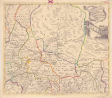
Download allTitle: No. 8, Provinciarum Ustiugae et Chlynovi nec non Territorium Iarenscensis Vagae Ustiugae Soliwytschegdae et Totmae Delineatio Geographica
Subtitle:
Contributor:
Imperatorskaâ akademiâ nauk (Petersburg)
Publisher:
Entworffen bey der Kayserl. Academie der Wissenschaften
Place of publishing:
Description:
Scale [ca 1:1 500 000] ; 1 map : copperplate engraving, hand col. ; 48x55 cm ; Map from: Atlas Russicus. - St. Petersburg, 1745 ; Map title in Latin, geographical names in Russian (in latin alphabet)
Relation:
Detailed Resource Type:
Resource Identifier:
Source:
CBGiOŚ. IGiPZ PAN, call no. B.7153 [5]
Language:
Rights:
Terms of use:
Digitizing institution:
Institute of Geography and Spatial Organization of the Polish Academy of Sciences
Original in:
Projects co-financed by:
Access:
Object collections:
- Digital Repository of Scientific Institutes > Partners' collections > Institute of Geography and Spatial Organization PAS (IGiPZ PAN) > Library
- Digital Repository of Scientific Institutes > Partners' collections > Institute of Geography and Spatial Organization PAS (IGiPZ PAN) > Library > Maps and atlases
- Digital Repository of Scientific Institutes > Literature > Maps/Atlases
Last modified:
Mar 12, 2021
In our library since:
Mar 12, 2021
Number of object content downloads / hits:
30
All available object's versions:
https://rcin.org.pl./publication/72217
Show description in RDF format:
Show description in RDFa format:
Show description in OAI-PMH format:
Objects Similar
Bautista, Carlos Olszańska, Agnieszka Berezowska-Cnota, Teresa Fedyń, Hubert Jastrzębski, Tomasz Nowakowski, Robert Marcela, Agnieszka Selva, Nuria

 INSTYTUT ARCHEOLOGII I ETNOLOGII POLSKIEJ AKADEMII NAUK
 INSTYTUT BADAŃ LITERACKICH POLSKIEJ AKADEMII NAUK
 INSTYTUT BADAWCZY LEŚNICTWA
 INSTYTUT BIOLOGII DOŚWIADCZALNEJ IM. MARCELEGO NENCKIEGO POLSKIEJ AKADEMII NAUK
 INSTYTUT BIOLOGII SSAKÓW POLSKIEJ AKADEMII NAUK
 INSTYTUT CHEMII FIZYCZNEJ PAN
 INSTYTUT CHEMII ORGANICZNEJ PAN
 INSTYTUT FILOZOFII I SOCJOLOGII PAN
 INSTYTUT GEOGRAFII I PRZESTRZENNEGO ZAGOSPODAROWANIA PAN
 INSTYTUT HISTORII im. TADEUSZA MANTEUFFLA POLSKIEJ AKADEMII NAUK
 INSTYTUT JĘZYKA POLSKIEGO POLSKIEJ AKADEMII NAUK
 INSTYTUT MATEMATYCZNY PAN
 INSTYTUT MEDYCYNY DOŚWIADCZALNEJ I KLINICZNEJ IM.MIROSŁAWA MOSSAKOWSKIEGO POLSKIEJ AKADEMII NAUK
 INSTYTUT PODSTAWOWYCH PROBLEMÓW TECHNIKI PAN
 INSTYTUT SLAWISTYKI PAN
 SIEĆ BADAWCZA ŁUKASIEWICZ - INSTYTUT TECHNOLOGII MATERIAŁÓW ELEKTRONICZNYCH
 MUZEUM I INSTYTUT ZOOLOGII POLSKIEJ AKADEMII NAUK
 INSTYTUT BADAŃ SYSTEMOWYCH PAN
 INSTYTUT BOTANIKI IM. WŁADYSŁAWA SZAFERA POLSKIEJ AKADEMII NAUK


