- About project
- Collections
- Indexes
- Recently viewed
-
RCIN Repositories
-
 INSTYTUT ARCHEOLOGII I ETNOLOGII POLSKIEJ AKADEMII NAUK
-
 INSTYTUT BADAŃ LITERACKICH POLSKIEJ AKADEMII NAUK
-
 INSTYTUT BADAWCZY LEŚNICTWA
-
 INSTYTUT BIOLOGII DOŚWIADCZALNEJ IM. MARCELEGO NENCKIEGO POLSKIEJ AKADEMII NAUK
-
 INSTYTUT BIOLOGII SSAKÓW POLSKIEJ AKADEMII NAUK
-
 INSTYTUT CHEMII FIZYCZNEJ PAN
-
 INSTYTUT CHEMII ORGANICZNEJ PAN
-
 INSTYTUT FILOZOFII I SOCJOLOGII PAN
-
 INSTYTUT GEOGRAFII I PRZESTRZENNEGO ZAGOSPODAROWANIA PAN
-
 INSTYTUT HISTORII im. TADEUSZA MANTEUFFLA POLSKIEJ AKADEMII NAUK
-
 INSTYTUT JĘZYKA POLSKIEGO POLSKIEJ AKADEMII NAUK
-
 INSTYTUT MATEMATYCZNY PAN
-
 INSTYTUT MEDYCYNY DOŚWIADCZALNEJ I KLINICZNEJ IM.MIROSŁAWA MOSSAKOWSKIEGO POLSKIEJ AKADEMII NAUK
-
 INSTYTUT PODSTAWOWYCH PROBLEMÓW TECHNIKI PAN
-
 INSTYTUT SLAWISTYKI PAN
-
 SIEĆ BADAWCZA ŁUKASIEWICZ - INSTYTUT TECHNOLOGII MATERIAŁÓW ELEKTRONICZNYCH
-
 MUZEUM I INSTYTUT ZOOLOGII POLSKIEJ AKADEMII NAUK
-
 INSTYTUT BADAŃ SYSTEMOWYCH PAN
-
 INSTYTUT BOTANIKI IM. WŁADYSŁAWA SZAFERA POLSKIEJ AKADEMII NAUK
-
- Search in all Repository
- Literature and maps
- Archeology
- Mills database
- Natural sciences
Advanced search
Advanced search
Advanced search
Advanced search
Advanced search

Object
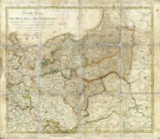
Title: General Karte von Ost- West- Süd- und Neu- Ostpreussen : dem Grenz Tractate vom Jahre 1797 gemäss entworfen, nach den jetzigen 8 Kammer Departements abgetheilt, und mit den neu angelegten Post-Coursen versehen
Subtitle:
Contributor:
Jäck, Carl (1763–1808) ; Matthias, Wilhelm Heinrich (1763–1833) : Rys. ; Simon Schropp und Comp. (Berlin)
Publisher:
im Verlag von Simon Schropp et Comp.
Place of publishing:
Description:
Skala [ca 1:1 700 000], Gemeine Deutsche Meilen 15 auf einen Grad ; 1 mapa : miedzior., ręcznie kolor. ; 42x49 cm, na ark. 47x54 cm ; Pod tyt.: gestochen von Carl Jäck Berlin 1800, die Post-Course gezeichnet von W. H. Matthias Registrator des Königl: General Post-Amts. Pod ramką mapy: Verlag von Simon Schropp et Comp. 1798 ; Ręcznie kolor. granice polityczno-administracyje. Na mapie zaznaczone m.in. wartownie pocztowe (Postwärterei) oraz liczba postojów ekspedycji pocztowej. Wokół ramki z siatką geograficzną dołączone ozn. literowe i cyfrowe (siatka skorowidzowa) ; Południk zerowy Ferro ; Ganz Neue verbesserte ausgabe im Jahr 1800 ; Tyt. w jęz. niem. i fr., treść mapy w jęz. niem.
Detailed Resource Type:
Format:
Resource Identifier:
Source:
CBGiOŚ. IGiPZ PAN, sygn. Ds.8857 [II.5A-1] ; click here to follow the link
Language:
Rights:
Terms of use:
Digitizing institution:
Instytut Geografii i Przestrzennego Zagospodarowania Polskiej Akademii Nauk
Original in:
Projects co-financed by:
Program Operacyjny Innowacyjna Gospodarka, lata 2010-2014, Priorytet 2. Infrastruktura strefy B + R ; Unia Europejska. Europejski Fundusz Rozwoju Regionalnego
Access:
Object collections:
- Digital Repository of Scientific Institutes > Partners' collections > Institute of Geography and Spatial Organization PAS (IGiPZ PAN) > Library
- Digital Repository of Scientific Institutes > Partners' collections > Institute of Geography and Spatial Organization PAS (IGiPZ PAN) > Library > Maps and atlases
- Digital Repository of Scientific Institutes > Literature > Maps/Atlases
Last modified:
Oct 2, 2020
In our library since:
Jul 11, 2014
Number of object content downloads / hits:
747
All available object's versions:
https://rcin.org.pl./publication/52305
Show description in RDF format:
Show description in RDFa format:
Show description in OAI-PMH format:
Objects Similar
Sotzmann, Daniel Fridrich (1754–1840)
Sotzmann, Daniel Fridrich (1754–1840)
Sotzmann, Daniel Fridrich (1754–1840) Gürsch, Carl Friedrich
Sotzmann, Daniel Fridrich (1754–1840) Gürsch, Carl Friedrich
Sotzmann, Daniel Fridrich (1754–1840) Penningh, Harry John Glassbach, Carl Christian (1751-post 1791) Schmidt, Friedrich August Sander, Wilhelm (c. 1766 – 1836)
Sotzmann, Daniel Fridrich (1754–1840) Berger, Daniel (1744–1824) Jäck, Carl (1763–1808)
Gilly, David (1748–1808) Sotzmann, Daniel Fridrich (1754–1840)


