- About project
- Collections
- Indexes
- Recently viewed
-
RCIN Repositories
-
 INSTYTUT ARCHEOLOGII I ETNOLOGII POLSKIEJ AKADEMII NAUK
-
 INSTYTUT BADAŃ LITERACKICH POLSKIEJ AKADEMII NAUK
-
 INSTYTUT BADAWCZY LEŚNICTWA
-
 INSTYTUT BIOLOGII DOŚWIADCZALNEJ IM. MARCELEGO NENCKIEGO POLSKIEJ AKADEMII NAUK
-
 INSTYTUT BIOLOGII SSAKÓW POLSKIEJ AKADEMII NAUK
-
 INSTYTUT CHEMII FIZYCZNEJ PAN
-
 INSTYTUT CHEMII ORGANICZNEJ PAN
-
 INSTYTUT FILOZOFII I SOCJOLOGII PAN
-
 INSTYTUT GEOGRAFII I PRZESTRZENNEGO ZAGOSPODAROWANIA PAN
-
 INSTYTUT HISTORII im. TADEUSZA MANTEUFFLA POLSKIEJ AKADEMII NAUK
-
 INSTYTUT JĘZYKA POLSKIEGO POLSKIEJ AKADEMII NAUK
-
 INSTYTUT MATEMATYCZNY PAN
-
 INSTYTUT MEDYCYNY DOŚWIADCZALNEJ I KLINICZNEJ IM.MIROSŁAWA MOSSAKOWSKIEGO POLSKIEJ AKADEMII NAUK
-
 INSTYTUT PODSTAWOWYCH PROBLEMÓW TECHNIKI PAN
-
 INSTYTUT SLAWISTYKI PAN
-
 SIEĆ BADAWCZA ŁUKASIEWICZ - INSTYTUT TECHNOLOGII MATERIAŁÓW ELEKTRONICZNYCH
-
 MUZEUM I INSTYTUT ZOOLOGII POLSKIEJ AKADEMII NAUK
-
 INSTYTUT BADAŃ SYSTEMOWYCH PAN
-
 INSTYTUT BOTANIKI IM. WŁADYSŁAWA SZAFERA POLSKIEJ AKADEMII NAUK
-
- Search in all Repository
- Literature and maps
- Archeology
- Mills database
- Natural sciences
Advanced search
Advanced search
Advanced search
Advanced search
Advanced search

Object
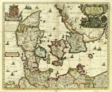
Title: Regni Daniæ, Novißima Et Accuratißima Tabula
Subtitle:
Regni Daniae, Novissima Et Accuratissima Tabula
Publisher:
Place of publishing:
Description:
Skala [ca 1:1 100 000], podziałka liniowa: Milliaria Germanica communia ; 1 mapa : miedzior., kolor. ręcznie ; 45x54 cm ; Mapa pochodzi z: Atlas Selectus ; W lewym górnym rogu w parerdze pod herbem Oldenburgów: Potentißimo Invictißimoq[ue] D. Christiano v. Daniae, Norvegiae, Gotthor., Vandalorum Regi etc. Hanc Daniæ Tabulam D. D. D. Visscher ; Kartusz roccaille oparty o herb Danii
Detailed Resource Type:
Format:
Resource Identifier:
Source:
CBGiOŚ. IGiPZ PAN, call no. B.1643[12] ; click here to follow the link
Language:
Rights:
Terms of use:
Digitizing institution:
Institute of Geography and Spatial Organization of the Polish Academy of Sciences
Original in:
Projects co-financed by:
Programme Innovative Economy, 2010-2014, Priority Axis 2. R&D infrastructure ; European Union. European Regional Development Fund
Access:
Object collections:
- Digital Repository of Scientific Institutes > Partners' collections > Institute of Geography and Spatial Organization PAS (IGiPZ PAN) > Library
- Digital Repository of Scientific Institutes > Partners' collections > Institute of Geography and Spatial Organization PAS (IGiPZ PAN) > Library > Maps and atlases
- Digital Repository of Scientific Institutes > Literature > Maps/Atlases
Last modified:
Mar 25, 2021
In our library since:
Mar 21, 2014
Number of object content downloads / hits:
91
All available object's versions:
https://rcin.org.pl./publication/42405
Show description in RDF format:
Show description in RDFa format:
Show description in OAI-PMH format:
| Edition name | Date |
|---|---|
| Visscher, Nicolaes Jansz (1649-1702), [ante 1698], Regni Daniæ, Novißima Et Accuratißima Tabula | Mar 25, 2021 |
Objects Similar
Visscher, Nicolaes Jansz (1649–1702)
Visscher, Nicolaes Jansz (1649–1702)
Wit, Frederick de (1630–1706)
Sanson, Nicolas (1600–1667)
Cieszyńska, Beata Żukowska, Maria Helena Giebułtowski, Jerzy
Beauplan, Guillaume Le Vasseur de (c. 1600 – 1675) Danckerts, Dancker (1634?-1666)
Wit, Frederick de (1630–1706)


