- Search in all Repository
- Literature and maps
- Archeology
- Mills database
- Natural sciences
Advanced search
Advanced search
Advanced search
Advanced search
Advanced search

Object
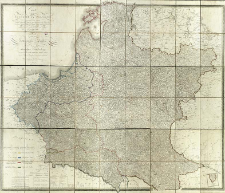
Title: Carte du ci-dévant Royaume de Pologne dans son état actuel dressée d'après les cartes de Gilly, Liesganig, Mayer, Schroetter, et Textor et d'après l'atlas de L'Empire Russe du Général Suchtelen = Carte des vormaligen ganzen Königreichs Pohlen nach seiner dermaligen Eintheilung Aus denen Charten des Gilly, Liesganig, Mayer, Schroetter und Textor, dann des Atlasses des Russischen Kayserthumes von General Suchtelen
Subtitle:
Publisher:
Place of publishing:
Description:
Scala [ca 1:900 000] ; 1 map on 9 sheets : copperplate engraving, hand col. ; in entirety 165x138 cm ; Prime meridian Ferro ; The map was based on Nordmann's map of 1813 ; Cited in: Centralny Katalog Zbiorów Kartograficznych w Polsce, Z. 5, Cz. 1, poz. 61 ; Cited in: Mapy Królestwa Polskiego wydane w latach 1815-1915 w zbiorach Biblioteki Narodowej / Lucyna Szaniawska. - Warszawa, 1997. - (Studia i Materiały z Historii Kartografii ; XVI), poz. 60
Detailed Resource Type:
Format:
File size 29,4 MB ; image/x.djvu
Resource Identifier:
Source:
CBGiOŚ. IGiPZ PAN, call no. Ds.1292 [IX.2-s] ; click here to follow the link
Language:
Rights:
Terms of use:
Digitizing institution:
Institute of Geography and Spatial Organization of the Polish Academy of Sciences
Original in:
Projects co-financed by:
Programme Innovative Economy, 2010-2014, Priority Axis 2. R&D infrastructure ; European Union. European Regional Development Fund
Access:
Object collections:
- Digital Repository of Scientific Institutes > Partners' collections > Institute of Geography and Spatial Organization PAS (IGiPZ PAN) > Library
- Digital Repository of Scientific Institutes > Partners' collections > Institute of Geography and Spatial Organization PAS (IGiPZ PAN) > Library > Maps and atlases
- Digital Repository of Scientific Institutes > Literature > Maps/Atlases
Last modified:
Oct 2, 2020
In our library since:
Aug 22, 2011
Number of object content downloads / hits:
1280
All available object's versions:
https://rcin.org.pl./publication/2370
Show description in RDF format:
Show description in RDFa format:
Show description in OAI-PMH format:
Objects Similar
Nordmann, A. P. H.
Nordmann, A. P. H.
Samborska-Kukuć, Dorota Jaros, Maja Giebułtowski, Jerzy
Fielitz, Teodor Gustaw
Mollo, Tranquillo (1767–1837)
Kolberg, Krzysztof Juliusz Henryk (1776–1831)

 INSTYTUT ARCHEOLOGII I ETNOLOGII POLSKIEJ AKADEMII NAUK
 INSTYTUT BADAŃ LITERACKICH POLSKIEJ AKADEMII NAUK
 INSTYTUT BADAWCZY LEŚNICTWA
 INSTYTUT BIOLOGII DOŚWIADCZALNEJ IM. MARCELEGO NENCKIEGO POLSKIEJ AKADEMII NAUK
 INSTYTUT BIOLOGII SSAKÓW POLSKIEJ AKADEMII NAUK
 INSTYTUT CHEMII FIZYCZNEJ PAN
 INSTYTUT CHEMII ORGANICZNEJ PAN
 INSTYTUT FILOZOFII I SOCJOLOGII PAN
 INSTYTUT GEOGRAFII I PRZESTRZENNEGO ZAGOSPODAROWANIA PAN
 INSTYTUT HISTORII im. TADEUSZA MANTEUFFLA POLSKIEJ AKADEMII NAUK
 INSTYTUT JĘZYKA POLSKIEGO POLSKIEJ AKADEMII NAUK
 INSTYTUT MATEMATYCZNY PAN
 INSTYTUT MEDYCYNY DOŚWIADCZALNEJ I KLINICZNEJ IM.MIROSŁAWA MOSSAKOWSKIEGO POLSKIEJ AKADEMII NAUK
 INSTYTUT PODSTAWOWYCH PROBLEMÓW TECHNIKI PAN
 INSTYTUT SLAWISTYKI PAN
 SIEĆ BADAWCZA ŁUKASIEWICZ - INSTYTUT TECHNOLOGII MATERIAŁÓW ELEKTRONICZNYCH
 MUZEUM I INSTYTUT ZOOLOGII POLSKIEJ AKADEMII NAUK
 INSTYTUT BADAŃ SYSTEMOWYCH PAN
 INSTYTUT BOTANIKI IM. WŁADYSŁAWA SZAFERA POLSKIEJ AKADEMII NAUK


