- About project
- Collections
- Indexes
- Recently viewed
-
RCIN Repositories
-
 INSTYTUT ARCHEOLOGII I ETNOLOGII POLSKIEJ AKADEMII NAUK
-
 INSTYTUT BADAŃ LITERACKICH POLSKIEJ AKADEMII NAUK
-
 INSTYTUT BADAWCZY LEŚNICTWA
-
 INSTYTUT BIOLOGII DOŚWIADCZALNEJ IM. MARCELEGO NENCKIEGO POLSKIEJ AKADEMII NAUK
-
 INSTYTUT BIOLOGII SSAKÓW POLSKIEJ AKADEMII NAUK
-
 INSTYTUT CHEMII FIZYCZNEJ PAN
-
 INSTYTUT CHEMII ORGANICZNEJ PAN
-
 INSTYTUT FILOZOFII I SOCJOLOGII PAN
-
 INSTYTUT GEOGRAFII I PRZESTRZENNEGO ZAGOSPODAROWANIA PAN
-
 INSTYTUT HISTORII im. TADEUSZA MANTEUFFLA POLSKIEJ AKADEMII NAUK
-
 INSTYTUT JĘZYKA POLSKIEGO POLSKIEJ AKADEMII NAUK
-
 INSTYTUT MATEMATYCZNY PAN
-
 INSTYTUT MEDYCYNY DOŚWIADCZALNEJ I KLINICZNEJ IM.MIROSŁAWA MOSSAKOWSKIEGO POLSKIEJ AKADEMII NAUK
-
 INSTYTUT PODSTAWOWYCH PROBLEMÓW TECHNIKI PAN
-
 INSTYTUT SLAWISTYKI PAN
-
 SIEĆ BADAWCZA ŁUKASIEWICZ - INSTYTUT TECHNOLOGII MATERIAŁÓW ELEKTRONICZNYCH
-
 MUZEUM I INSTYTUT ZOOLOGII POLSKIEJ AKADEMII NAUK
-
 INSTYTUT BADAŃ SYSTEMOWYCH PAN
-
 INSTYTUT BOTANIKI IM. WŁADYSŁAWA SZAFERA POLSKIEJ AKADEMII NAUK
-
- Search in all Repository
- Literature and maps
- Archeology
- Mills database
- Natural sciences
Advanced search
Advanced search
Advanced search
Advanced search
Advanced search

Object
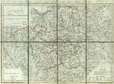
Title: Polen nach den Letzten Friedenschlüssen, nebst den angränzenden Laendern
Subtitle:
Karta Królestwa Polskiégo, z przyległemi kraijami, podług ostatniégo pokoju w Wiuniu 1817 Roku
Publisher:
Place of publishing:
Description:
Scale [ca 1:2 000 000], Deutsche oder Geographische Meilen 15 auf 1 Grad [20 = 6,8 cm] ; 1 map : copperplate engraving, hand col. ; 33x46 cm ; Prime meridian [Ferro] ; On the map: Lehrbuch der Geographie II te Abthl. Seite 96 ; Probable from: Allgemeiner Hand-Atlas zum Gebrauch für die Jugend in höhern und nieder Schule [...] / von Joseph Dirwaldt. - Wien, 1818. - [leaf no] 44
Detailed Resource Type:
Format:
File size 2,5 MB ; image/x.djvu
Resource Identifier:
Source:
CBGiOŚ. IGiPZ PAN, call no. Ds.8097 [I.2A-10] ; click here to follow the link
Language:
Rights:
Terms of use:
Digitizing institution:
Institute of Geography and Spatial Organization of the Polish Academy of Sciences
Original in:
Projects co-financed by:
Programme Innovative Economy, 2010-2014, Priority Axis 2. R&D infrastructure ; European Union. European Regional Development Fund
Access:
Object collections:
- Digital Repository of Scientific Institutes > Partners' collections > Institute of Geography and Spatial Organization PAS (IGiPZ PAN) > Library > Maps and atlases
- Digital Repository of Scientific Institutes > Literature > Maps/Atlases
Last modified:
Oct 2, 2020
In our library since:
Sep 6, 2011
Number of object content downloads / hits:
406
All available object's versions:
https://rcin.org.pl./publication/2005
Show description in RDF format:
Show description in RDFa format:
Show description in OAI-PMH format:
| Edition name | Date |
|---|---|
| Mollo, Tranquillo (1767-1837). Wyd., [1818], Polen nach den Letzten Friedenschlüssen, nebst den angränzenden Laendern. | Oct 2, 2020 |
Objects Similar
Mollo, Tranquillo (1767–1837)
Samborska-Kukuć, Dorota Jaros, Maja Giebułtowski, Jerzy
Fielitz, Teodor Gustaw
Nordmann, A. P. H.
Nordmann, A. P. H.
Kolberg, Krzysztof Juliusz Henryk (1776–1831)


