- O repozytorium
- Kolekcje
- Indeksy
- Historia przeglądania
-
Repozytoria RCIN
-
 INSTYTUT ARCHEOLOGII I ETNOLOGII POLSKIEJ AKADEMII NAUK
-
 INSTYTUT BADAŃ LITERACKICH POLSKIEJ AKADEMII NAUK
-
 INSTYTUT BADAWCZY LEŚNICTWA
-
 INSTYTUT BIOLOGII DOŚWIADCZALNEJ IM. MARCELEGO NENCKIEGO POLSKIEJ AKADEMII NAUK
-
 INSTYTUT BIOLOGII SSAKÓW POLSKIEJ AKADEMII NAUK
-
 INSTYTUT CHEMII FIZYCZNEJ PAN
-
 INSTYTUT CHEMII ORGANICZNEJ PAN
-
 INSTYTUT FILOZOFII I SOCJOLOGII PAN
-
 INSTYTUT GEOGRAFII I PRZESTRZENNEGO ZAGOSPODAROWANIA PAN
-
 INSTYTUT HISTORII im. TADEUSZA MANTEUFFLA POLSKIEJ AKADEMII NAUK
-
 INSTYTUT JĘZYKA POLSKIEGO POLSKIEJ AKADEMII NAUK
-
 INSTYTUT MATEMATYCZNY PAN
-
 INSTYTUT MEDYCYNY DOŚWIADCZALNEJ I KLINICZNEJ IM.MIROSŁAWA MOSSAKOWSKIEGO POLSKIEJ AKADEMII NAUK
-
 INSTYTUT PODSTAWOWYCH PROBLEMÓW TECHNIKI PAN
-
 INSTYTUT SLAWISTYKI PAN
-
 SIEĆ BADAWCZA ŁUKASIEWICZ - INSTYTUT TECHNOLOGII MATERIAŁÓW ELEKTRONICZNYCH
-
 MUZEUM I INSTYTUT ZOOLOGII POLSKIEJ AKADEMII NAUK
-
 INSTYTUT BADAŃ SYSTEMOWYCH PAN
-
 INSTYTUT BOTANIKI IM. WŁADYSŁAWA SZAFERA POLSKIEJ AKADEMII NAUK
-
- Wyszukaj w całym Repozytorium
- Piśmiennictwo i mapy
- Archeologia
- Baza Młynów
- Nauki przyrodnicze
Wyszukiwanie zaawansowane
Wyszukiwanie zaawansowane
Wyszukiwanie zaawansowane
Wyszukiwanie zaawansowane
Wyszukiwanie zaawansowane

Obiekt
Dostępne formaty:
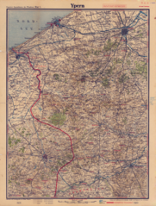
Pobierz wszystkieTytuł: Paasche's Spezialkarten der Westfront (Belgien und Frankreich) : Maßstab 1:105 000. Blatt 1, Ypern
Twórca:
Paasche, Walter (18..-1932). Redaktor ; Paasche & Luz Kartographische Anstalt. Wydawca
Data wydania/powstania:
Typ zasobu:
Inny tytuł:
Paasche's Spezialkarten der Westfront. Blatt 1, Ypern ; Ypern
Wydawca:
Miejsce wydania:
Opis:
Skala 1:105 000 ; 1 mapa : kolor. ; 41x55 cm, złoż. 15x11 cm ; Na okł. adnot.: nach den deutschen, belgischen und franzöischen Generalstabskarten neu gezeichnet ; Fünffarbiger Druck mit Eintrag der multmaßlichen Frontlinie und Textbeilage ; 12 Blätter ; W lewym dolnym narożniku ramki nadruk: X.17 - prawdopodobnie data druku lub wyd. mapy. Datowanie mapy związane również z treścią mapy: działania wojenne pod Ypres (Flandria) prowadzone były w 1917 r
Czasopismo/Seria/cykl:
Paasche's Spezialkarten der Westfront (Belgien und Frankreich) : 12 Blätter
Szczegółowy typ zasobu:
Format:
Identyfikator zasobu:
Źródło:
CBGiOŚ. IGiPZ PAN, sygn. C.458[10] ; kliknij tutaj, żeby przejść
Język:
Prawa:
Zasady wykorzystania:
Digitalizacja:
Instytut Geografii i Przestrzennego Zagospodarowania Polskiej Akademii Nauk
Lokalizacja oryginału:
Dofinansowane ze środków:
Dostęp:
Kolekcje, do których przypisany jest obiekt:
- Repozytorium Cyfrowe Instytutów Naukowych > Kolekcje Partnerów > Instytut Geografii i Przestrzennego Zagospodarowania PAN > Biblioteka Instytutu
- Repozytorium Cyfrowe Instytutów Naukowych > Kolekcje Partnerów > Instytut Geografii i Przestrzennego Zagospodarowania PAN > Biblioteka Instytutu > Mapy i atlasy
- Repozytorium Cyfrowe Instytutów Naukowych > Piśmiennictwo > Mapy/Atlasy
Data ostatniej modyfikacji:
2 paź 2020
Data dodania obiektu:
18 gru 2019
Liczba pobrań / odtworzeń:
75
Wszystkie dostępne wersje tego obiektu:
https://rcin.org.pl./publication/89799
Wyświetl opis w formacie RDF:
Wyświetl opis w formacie RDFa:
Wyświetl opis w formacie OAI-PMH:
| Nazwa wydania | Data |
|---|---|
| Paasche's Spezialkarten der Westfront (Belgien und Frankreich). Blatt 1, Ypern, [1917] | 2 paź 2020 |
Obiekty Podobne
Paasche, Walter (18..-1932). Redaktor Paasche & Luz Kartographische Anstalt. Wydawca
Paasche, Walter (18..-1932). Redaktor Paasche & Luz Kartographische Anstalt. Wydawca
Paasche, Walter (18..-1932). Redaktor Paasche & Luz Kartographische Anstalt. Wydawca
Paasche, Walter (18..-1932). Redaktor Paasche & Luz Kartographische Anstalt. Wydawca
Paasche, Walter (18..-1932). Redaktor Paasche & Luz Kartographische Anstalt. Wydawca
Paasche, Walter (18..-1932). Redaktor Paasche & Luz Kartographische Anstalt. Wydawca
Paasche, Walter (18..-1932). Redaktor Paasche & Luz Kartographische Anstalt. Wydawca
Paasche, Walter (18..-1932). Redaktor Paasche & Luz Kartographische Anstalt. Wydawca


