- Search in all Repository
- Literature and maps
- Archeology
- Mills database
- Natural sciences
Advanced search
Advanced search
Advanced search
Advanced search
Advanced search

Object
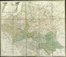
Title: Generalkarte von Polen, Litauen, und den Angraenzenden Laendern nach Zannoni, Folin, Uz, Pfau &. &. ; Generalkarte von Polen, Litauen, und den Angrænzenden Lændern
Creator:
Schraembl, Franz Anton (1751–1803) : Oprac. ; Benedicti, Hieronymus (1756–1809) : Ryt.
Date issued/created:
Resource type:
Publisher:
Place of publishing:
Description:
Scale [ca 1:1 300 000] ; 1 map on 4 sheets : copperplate engraving, hand col. ; each sheet 43x50 cm, in entirety 85x99 cm ; Prime meridian Ferro ; Cited in: Centralny Katalog Zbiorów Kartograficznych W Posce, Z. 6, poz. 66 ; Cited in: Imago Poloniae, T. 2, s. 121, poz. K54
Detailed Resource Type:
Format:
File size 7,5 MB ; image/x.djvu
Resource Identifier:
Source:
CBGiOŚ. IGiPZ PAN, sign. Ds.8042 [IX.2-o] ; click here to follow the link
Language:
Rights:
Terms of use:
Digitizing institution:
Institute of Geography and Spatial Organization of the Polish Academy of Sciences
Original in:
Projects co-financed by:
Programme Innovative Economy, 2010-2014, Priority Axis 2. R&D infrastructure ; European Union. European Regional Development Fund
Access:
Object collections:
- Digital Repository of Scientific Institutes > Partners' collections > Institute of Geography and Spatial Organization PAS (IGiPZ PAN) > Library
- Digital Repository of Scientific Institutes > Partners' collections > Institute of Geography and Spatial Organization PAS (IGiPZ PAN) > Library > Maps and atlases
- Digital Repository of Scientific Institutes > Literature > Maps/Atlases
Last modified:
Oct 2, 2020
In our library since:
Aug 22, 2011
Number of object content downloads / hits:
434
All available object's versions:
https://rcin.org.pl./publication/6598
Show description in RDF format:
Show description in RDFa format:
Show description in OAI-PMH format:
| Edition name | Date |
|---|---|
| Generalkarte von Polen, Litauen, und den angraenzenden Laendern. Nach Zannoni, Folin, Uz, Pfau etc. | Oct 2, 2020 |
Objects Similar
Güldenstädt, Johann Anton (1745–1781) Schraembl, Franz Anton (1751–1803) Wussin Joseph. Rys.
Homann, Johann Baptist (1664–1724)
Homann, Johann Baptist (1664–1724)
Kanter, Jan Jakub (1738–1786) Chodowiecki, Daniel Mikołaj (1726–1801) Schleuen, Johann David (c. 1720 – 1774)
Pfau, Theodor Philipp (1725–1794) Glassbach, Christian Benjamin (1724–1779)
Delisle, Guillaume (1675–1726) Buache, Philippe (1700–1773)
Sotzmann, Daniel Fridrich (1754–1840) Penningh, Harry John Glassbach, Carl Christian (1751-post 1791) Schmidt, Friedrich August Sander, Wilhelm (c. 1766 – 1836)

 INSTYTUT ARCHEOLOGII I ETNOLOGII POLSKIEJ AKADEMII NAUK
 INSTYTUT BADAŃ LITERACKICH POLSKIEJ AKADEMII NAUK
 INSTYTUT BADAWCZY LEŚNICTWA
 INSTYTUT BIOLOGII DOŚWIADCZALNEJ IM. MARCELEGO NENCKIEGO POLSKIEJ AKADEMII NAUK
 INSTYTUT BIOLOGII SSAKÓW POLSKIEJ AKADEMII NAUK
 INSTYTUT CHEMII FIZYCZNEJ PAN
 INSTYTUT CHEMII ORGANICZNEJ PAN
 INSTYTUT FILOZOFII I SOCJOLOGII PAN
 INSTYTUT GEOGRAFII I PRZESTRZENNEGO ZAGOSPODAROWANIA PAN
 INSTYTUT HISTORII im. TADEUSZA MANTEUFFLA POLSKIEJ AKADEMII NAUK
 INSTYTUT JĘZYKA POLSKIEGO POLSKIEJ AKADEMII NAUK
 INSTYTUT MATEMATYCZNY PAN
 INSTYTUT MEDYCYNY DOŚWIADCZALNEJ I KLINICZNEJ IM.MIROSŁAWA MOSSAKOWSKIEGO POLSKIEJ AKADEMII NAUK
 INSTYTUT PODSTAWOWYCH PROBLEMÓW TECHNIKI PAN
 INSTYTUT SLAWISTYKI PAN
 SIEĆ BADAWCZA ŁUKASIEWICZ - INSTYTUT TECHNOLOGII MATERIAŁÓW ELEKTRONICZNYCH
 MUZEUM I INSTYTUT ZOOLOGII POLSKIEJ AKADEMII NAUK
 INSTYTUT BADAŃ SYSTEMOWYCH PAN
 INSTYTUT BOTANIKI IM. WŁADYSŁAWA SZAFERA POLSKIEJ AKADEMII NAUK


