- About project
- Collections
- Indexes
- Recently viewed
-
RCIN Repositories
-
 INSTYTUT ARCHEOLOGII I ETNOLOGII POLSKIEJ AKADEMII NAUK
-
 INSTYTUT BADAŃ LITERACKICH POLSKIEJ AKADEMII NAUK
-
 INSTYTUT BADAWCZY LEŚNICTWA
-
 INSTYTUT BIOLOGII DOŚWIADCZALNEJ IM. MARCELEGO NENCKIEGO POLSKIEJ AKADEMII NAUK
-
 INSTYTUT BIOLOGII SSAKÓW POLSKIEJ AKADEMII NAUK
-
 INSTYTUT CHEMII FIZYCZNEJ PAN
-
 INSTYTUT CHEMII ORGANICZNEJ PAN
-
 INSTYTUT FILOZOFII I SOCJOLOGII PAN
-
 INSTYTUT GEOGRAFII I PRZESTRZENNEGO ZAGOSPODAROWANIA PAN
-
 INSTYTUT HISTORII im. TADEUSZA MANTEUFFLA POLSKIEJ AKADEMII NAUK
-
 INSTYTUT JĘZYKA POLSKIEGO POLSKIEJ AKADEMII NAUK
-
 INSTYTUT MATEMATYCZNY PAN
-
 INSTYTUT MEDYCYNY DOŚWIADCZALNEJ I KLINICZNEJ IM.MIROSŁAWA MOSSAKOWSKIEGO POLSKIEJ AKADEMII NAUK
-
 INSTYTUT PODSTAWOWYCH PROBLEMÓW TECHNIKI PAN
-
 INSTYTUT SLAWISTYKI PAN
-
 SIEĆ BADAWCZA ŁUKASIEWICZ - INSTYTUT TECHNOLOGII MATERIAŁÓW ELEKTRONICZNYCH
-
 MUZEUM I INSTYTUT ZOOLOGII POLSKIEJ AKADEMII NAUK
-
 INSTYTUT BADAŃ SYSTEMOWYCH PAN
-
 INSTYTUT BOTANIKI IM. WŁADYSŁAWA SZAFERA POLSKIEJ AKADEMII NAUK
-
- Search in all Repository
- Literature and maps
- Archeology
- Mills database
- Natural sciences
Advanced search
Advanced search
Advanced search
Advanced search
Advanced search

Object
Available formats:
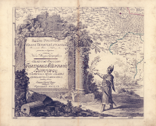
Download allTitle: Regni Poloniae Magni Ducatus Lituaniae Provinciarum Foedere et Vasallagio illis junctarum, et Regionum vicinarum Nova Mappa Geographica Borussiae Principi Friderico Henrico Ludovico, Friderici Regis Fratri Forti Benigno Musis Amico, humillime dedicata a Joanne Jacobo Kanter
Creator:
Kanter, Jan Jakub (1738–1786) : Druk. ; Chodowiecki, Daniel Mikołaj (1726–1801) : Ryt. ; Schleuen, Johann David (c. 1720 – 1774) : Ryt.
Date issued/created:
Resource type:
Subtitle:
Publisher:
Place of publishing:
Description:
Scale [ca 1:675 000] ; 1 map on 16 sheets : copperplate engraving, hand col. ; each sheet 44x50 cm + text: 1 leaf ; 48x60 cm ; Copy without: sheet 1 (with sheet index) and sheet 5 and leaf with text (Tabella Wszystkie Wojewodztwa, Ziemie Powiaty y Starostwa, Oraz y Rzeki pryncypalne vv sobie zavvieraiaca = Tabula, Palatinatus, Terras, Districtus, Capitaneatus et Fluvios Notatu Digniores Exhibens) ; According to Dzieje Kartografii Polskiej od XV do XVIII wieku / Karol Buczek map was published in 1771 ; Title, author and place of publication in Latin, legend of map and geographical names in Polish
Detailed Resource Type:
Format:
Resource Identifier:
Source:
xx002495806 ; CBGiOŚ. IGiPZ PAN, call no. B.1645[3] ; click here to follow the link
Language:
Rights:
Terms of use:
Digitizing institution:
Institute of Geography and Spatial Organization of the Polish Academy of Sciences
Original in:
Projects co-financed by:
Access:
Object collections:
- Digital Repository of Scientific Institutes > Partners' collections > Institute of Geography and Spatial Organization PAS (IGiPZ PAN) > Library
- Digital Repository of Scientific Institutes > Partners' collections > Institute of Geography and Spatial Organization PAS (IGiPZ PAN) > Library > Maps and atlases
- Digital Repository of Scientific Institutes > Literature > Maps/Atlases
Last modified:
Mar 29, 2021
In our library since:
Nov 7, 2019
Number of object content downloads / hits:
775
All available object's versions:
https://rcin.org.pl./publication/63049
Show description in RDF format:
Show description in RDFa format:
Show description in OAI-PMH format:
Objects Similar
Pfau, Theodor Philipp (1725–1794) Glassbach, Christian Benjamin (1724–1779)
Homann, Johann Baptist (1664–1724)
Schraembl, Franz Anton (1751–1803) Benedicti, Hieronymus (1756–1809)
Pfau, Theodor Philipp (1725–1794) Glassbach, Christian Benjamin (1724–1779)
Homann, Johann Baptist (1664–1724)
Homann, Johann Baptist (1664–1724)


