- Search in all Repository
- Literature and maps
- Archeology
- Mills database
- Natural sciences
Advanced search
Advanced search
Advanced search
Advanced search
Advanced search

Object
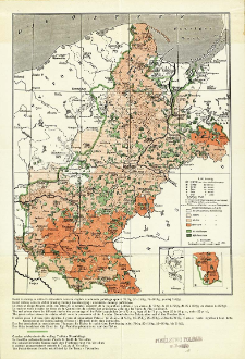
Title: Mapa etnograficzna Pomorza i Poznańskiego wydana w r. 1913 przez "Ostmarkenverein"
Subtitle:
Carte ethnographique de la Pomeranie et de la Posnanie publiée en 1913 par le "Ostmarkenverein" ; Ethnographic map of Pomerania and Posnania published in 1913 by the "Ostmarkenverein" ; Carta etnografica di Pomerania e della regione di Posen, edizione del 1913 della "Ostmarkenverein" ; Nationalitätenkarte von Pomerellen und Posen herausgegeben im J. 1913 vom "Ostmarkenverein"
Publisher:
Place of publishing:
Description:
Scale 1:1 500 000 ; 1 map : col. ; 24x19 cm, folded in cover 22x13 cm ; Cover title. On verso information about map in Polish, French, Englisch, Italian and German: "Mapa niniejsza jest autentyczną odbitką mapy etnograficznej Pomorza i Poznańskiego wydanej w r. 1913 przez niemiecki związek nacjonalistyczny "Ostmarkenverein". Opracowana została na podstawie powszechnego spisu ludności z dnia 1 grudnia 1910. Przedstawia według źródeł niemieckich przedwojenny stan etnograficzny ziem, które dziś wchodzą w skład Państwa Polskiego"
Detailed Resource Type:
Format:
File size 1,1 MB ; image/x.djvu
Resource Identifier:
Source:
CBGiOŚ. IGiPZ PAN, call no. D.11564 [II.5A-8] ; CBGiOŚ. IGiPZ PAN, call no. PTG D.737 [II.5A-4] ; click here to follow the link
Language:
Rights:
Terms of use:
Digitizing institution:
Institute of Geography and Spatial Organization of the Polish Academy of Sciences
Original in:
Projects co-financed by:
Programme Innovative Economy, 2010-2014, Priority Axis 2. R&D infrastructure ; European Union. European Regional Development Fund
Access:
Object collections:
- Digital Repository of Scientific Institutes > Partners' collections > Institute of Geography and Spatial Organization PAS (IGiPZ PAN) > Library
- Digital Repository of Scientific Institutes > Partners' collections > Institute of Geography and Spatial Organization PAS (IGiPZ PAN) > Library > Maps and atlases
- Digital Repository of Scientific Institutes > Partners' collections > Institute of Geography and Spatial Organization PAS (IGiPZ PAN) > Library > Selected collections > Polish Geographical Society Collection
- Digital Repository of Scientific Institutes > Literature > Maps/Atlases
Last modified:
Oct 2, 2020
In our library since:
Sep 1, 2011
Number of object content downloads / hits:
603
All available object's versions:
https://rcin.org.pl./publication/5758
Show description in RDF format:
Show description in RDFa format:
Show description in OAI-PMH format:
| Edition name | Date |
|---|---|
| Mapa etnograficzna Pomorza i Poznańskiego wydana w r. 1913 przez "Ostmarkenverein", [post 1918] | Oct 2, 2020 |
Objects Similar
Piotrowska, Magdalena Żychliński, Daniel
Olszewski, Piotr Kowalczyk, Jan Krzysztof
Ruta, Rafał Melke, Andrzej Komosiński, Karol Sienkiewicz, Paweł Rutkowski, Tomasz Wiśniewski, Konrad
Lesiński, Grzegorz Wojtaszyn, Grzegorz Błachowski, Grzegorz Zbonik, Mikołaj
Małecka-Kukawka, Jolanta Kukawka, Stanisław Adamczak, Kamil
Szczepanik, Paweł

 INSTYTUT ARCHEOLOGII I ETNOLOGII POLSKIEJ AKADEMII NAUK
 INSTYTUT BADAŃ LITERACKICH POLSKIEJ AKADEMII NAUK
 INSTYTUT BADAWCZY LEŚNICTWA
 INSTYTUT BIOLOGII DOŚWIADCZALNEJ IM. MARCELEGO NENCKIEGO POLSKIEJ AKADEMII NAUK
 INSTYTUT BIOLOGII SSAKÓW POLSKIEJ AKADEMII NAUK
 INSTYTUT CHEMII FIZYCZNEJ PAN
 INSTYTUT CHEMII ORGANICZNEJ PAN
 INSTYTUT FILOZOFII I SOCJOLOGII PAN
 INSTYTUT GEOGRAFII I PRZESTRZENNEGO ZAGOSPODAROWANIA PAN
 INSTYTUT HISTORII im. TADEUSZA MANTEUFFLA POLSKIEJ AKADEMII NAUK
 INSTYTUT JĘZYKA POLSKIEGO POLSKIEJ AKADEMII NAUK
 INSTYTUT MATEMATYCZNY PAN
 INSTYTUT MEDYCYNY DOŚWIADCZALNEJ I KLINICZNEJ IM.MIROSŁAWA MOSSAKOWSKIEGO POLSKIEJ AKADEMII NAUK
 INSTYTUT PODSTAWOWYCH PROBLEMÓW TECHNIKI PAN
 INSTYTUT SLAWISTYKI PAN
 SIEĆ BADAWCZA ŁUKASIEWICZ - INSTYTUT TECHNOLOGII MATERIAŁÓW ELEKTRONICZNYCH
 MUZEUM I INSTYTUT ZOOLOGII POLSKIEJ AKADEMII NAUK
 INSTYTUT BADAŃ SYSTEMOWYCH PAN
 INSTYTUT BOTANIKI IM. WŁADYSŁAWA SZAFERA POLSKIEJ AKADEMII NAUK


