- Wyszukaj w całym Repozytorium
- Piśmiennictwo i mapy
- Archeologia
- Baza Młynów
- Nauki przyrodnicze
Wyszukiwanie zaawansowane
Wyszukiwanie zaawansowane
Wyszukiwanie zaawansowane
Wyszukiwanie zaawansowane
Wyszukiwanie zaawansowane

Obiekt
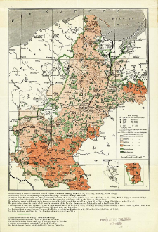
Tytuł: Mapa etnograficzna Pomorza i Poznańskiego wydana w r. 1913 przez "Ostmarkenverein"
Inny tytuł:
Carte ethnographique de la Pomeranie et de la Posnanie publiée en 1913 par le "Ostmarkenverein" ; Ethnographic map of Pomerania and Posnania published in 1913 by the "Ostmarkenverein" ; Carta etnografica di Pomerania e della regione di Posen, edizione del 1913 della "Ostmarkenverein" ; Nationalitätenkarte von Pomerellen und Posen herausgegeben im J. 1913 vom "Ostmarkenverein"
Wydawca:
Miejsce wydania:
Opis:
Skala 1:1 500 000 ; 1 mapa : kolor. ; 24x19 cm, złoż w okł. 22x13 cm ; Tyt. okł. Na drugiej s. okł. inform. o mapie w jęz. pol., fr., ang., wł. i niem.: "Mapa niniejsza jest autentyczną odbitką mapy etnograficznej Pomorza i Poznańskiego wydanej w r. 1913 przez niemiecki związek nacjonalistyczny "Ostmarkenverein". Opracowana została na podstawie powszechnego spisu ludności z dnia 1 grudnia 1910. Przedstawia według źródeł niemieckich przedwojenny stan etnograficzny ziem, które dziś wchodzą w skład Państwa Polskiego"
Szczegółowy typ zasobu:
Format:
Rozmiar pliku 1,1 MB ; image/x.djvu
Identyfikator zasobu:
Źródło:
CBGiOŚ. IGiPZ PAN, sygn. D.11564 [II.5A-8] ; CBGiOŚ. IGiPZ PAN, sygn. PTG D.737 [II.5A-4] ; kliknij tutaj, żeby przejść
Język:
Prawa:
Zasady wykorzystania:
Digitalizacja:
Instytut Geografii i Przestrzennego Zagospodarowania Polskiej Akademii Nauk
Lokalizacja oryginału:
Dofinansowane ze środków:
Program Operacyjny Innowacyjna Gospodarka, lata 2010-2014, Priorytet 2. Infrastruktura strefy B + R ; Unia Europejska. Europejski Fundusz Rozwoju Regionalnego
Dostęp:
Kolekcje, do których przypisany jest obiekt:
- Repozytorium Cyfrowe Instytutów Naukowych > Kolekcje Partnerów > Instytut Geografii i Przestrzennego Zagospodarowania PAN > Biblioteka Instytutu
- Repozytorium Cyfrowe Instytutów Naukowych > Kolekcje Partnerów > Instytut Geografii i Przestrzennego Zagospodarowania PAN > Biblioteka Instytutu > Mapy i atlasy
- Repozytorium Cyfrowe Instytutów Naukowych > Kolekcje Partnerów > Instytut Geografii i Przestrzennego Zagospodarowania PAN > Biblioteka Instytutu > Wybrane księgozbiory > Księgozbiór Polskiego Towarzystwa Geograficznego
- Repozytorium Cyfrowe Instytutów Naukowych > Piśmiennictwo > Mapy/Atlasy
Data ostatniej modyfikacji:
2 paź 2020
Data dodania obiektu:
1 wrz 2011
Liczba pobrań / odtworzeń:
684
Wszystkie dostępne wersje tego obiektu:
https://rcin.org.pl./publication/5758
Wyświetl opis w formacie RDF:
Wyświetl opis w formacie RDFa:
Wyświetl opis w formacie OAI-PMH:
| Nazwa wydania | Data |
|---|---|
| Mapa etnograficzna Pomorza i Poznańskiego wydana w r. 1913 przez "Ostmarkenverein", [post 1918] | 2 paź 2020 |
Obiekty Podobne
Wrzosek, Antoni (1908–1983) Zwierz, Stanisław
Spett, Jakub

 INSTYTUT ARCHEOLOGII I ETNOLOGII POLSKIEJ AKADEMII NAUK
 INSTYTUT BADAŃ LITERACKICH POLSKIEJ AKADEMII NAUK
 INSTYTUT BADAWCZY LEŚNICTWA
 INSTYTUT BIOLOGII DOŚWIADCZALNEJ IM. MARCELEGO NENCKIEGO POLSKIEJ AKADEMII NAUK
 INSTYTUT BIOLOGII SSAKÓW POLSKIEJ AKADEMII NAUK
 INSTYTUT CHEMII FIZYCZNEJ PAN
 INSTYTUT CHEMII ORGANICZNEJ PAN
 INSTYTUT FILOZOFII I SOCJOLOGII PAN
 INSTYTUT GEOGRAFII I PRZESTRZENNEGO ZAGOSPODAROWANIA PAN
 INSTYTUT HISTORII im. TADEUSZA MANTEUFFLA POLSKIEJ AKADEMII NAUK
 INSTYTUT JĘZYKA POLSKIEGO POLSKIEJ AKADEMII NAUK
 INSTYTUT MATEMATYCZNY PAN
 INSTYTUT MEDYCYNY DOŚWIADCZALNEJ I KLINICZNEJ IM.MIROSŁAWA MOSSAKOWSKIEGO POLSKIEJ AKADEMII NAUK
 INSTYTUT PODSTAWOWYCH PROBLEMÓW TECHNIKI PAN
 INSTYTUT SLAWISTYKI PAN
 SIEĆ BADAWCZA ŁUKASIEWICZ - INSTYTUT TECHNOLOGII MATERIAŁÓW ELEKTRONICZNYCH
 MUZEUM I INSTYTUT ZOOLOGII POLSKIEJ AKADEMII NAUK
 INSTYTUT BADAŃ SYSTEMOWYCH PAN
 INSTYTUT BOTANIKI IM. WŁADYSŁAWA SZAFERA POLSKIEJ AKADEMII NAUK


