- Wyszukaj w całym Repozytorium
- Piśmiennictwo i mapy
- Archeologia
- Baza Młynów
- Nauki przyrodnicze
Wyszukiwanie zaawansowane
Wyszukiwanie zaawansowane
Wyszukiwanie zaawansowane
Wyszukiwanie zaawansowane
Wyszukiwanie zaawansowane

Obiekt
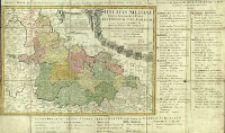
Tytuł: Ducatus Silesiae Tabula Geographica Prima Inferiorem Eius Partem seu Novem Principatus quorum insignia hic adjecta sunt, secundum statum recentissimum complectens ; Dvcatvs Silesiae Tabvla Geographica Prima Inferiorem Eivs Partem seu Novem Principatvs quorum insignia hic adjecta sunt, secundum statum recentissimum complectens
Inny tytuł:
Współtwórca:
Wydawca:
Miejsce wydania:
Opis:
Skala [ca 1:580 000] ; 1 mapa : miedzior., ręcznie kolor. ; 40x56 cm ; Miejsce wyd. wg. wydawcy ; Legenda: Explicatio signorum, umieszczona w parerdze w formie tkaniny podtrzymywanej przez putta ; Kartusz obramowany herbami: Świdnicy, Jaworzna, Głogowa, Wrocławia, Legnicy, Brzegu, Wołowa, Oleśnicy i Żagania. W kartuszu dwie podziałki ; Do mapy dołączony wykaz poszczególnych księstw śląskich: Erklaerung zu der Karte Nieder-Schlesien, so XI für stenthümer und IV Stands Herrschaften begreist ; Południk zerowy Ferro ; Mapa pochodzi z: Atlas Silesiae Id est Ducatus Silesiae z 1752 r. wyd. przez Spadkobierców Homanna ; Tyt. w jęz. łac. i fr.
Szczegółowy typ zasobu:
Format:
Identyfikator zasobu:
Źródło:
CBGiOŚ. IGiPZ PAN, sygn. Ds.8017 [II.7A-3] ; kliknij tutaj, żeby przejść
Język:
Prawa:
Zasady wykorzystania:
Digitalizacja:
Instytut Geografii i Przestrzennego Zagospodarowania Polskiej Akademii Nauk
Lokalizacja oryginału:
Dofinansowane ze środków:
Program Operacyjny Innowacyjna Gospodarka, lata 2010-2014, Priorytet 2. Infrastruktura strefy B + R ; Unia Europejska. Europejski Fundusz Rozwoju Regionalnego
Dostęp:
Kolekcje, do których przypisany jest obiekt:
- Repozytorium Cyfrowe Instytutów Naukowych > Kolekcje Partnerów > Instytut Geografii i Przestrzennego Zagospodarowania PAN > Biblioteka Instytutu
- Repozytorium Cyfrowe Instytutów Naukowych > Kolekcje Partnerów > Instytut Geografii i Przestrzennego Zagospodarowania PAN > Biblioteka Instytutu > Mapy i atlasy
- Repozytorium Cyfrowe Instytutów Naukowych > Piśmiennictwo > Mapy/Atlasy
Data ostatniej modyfikacji:
2 paź 2020
Data dodania obiektu:
30 sty 2014
Liczba pobrań / odtworzeń:
193
Wszystkie dostępne wersje tego obiektu:
https://rcin.org.pl./publication/51490
Wyświetl opis w formacie RDF:
Wyświetl opis w formacie RDFa:
Wyświetl opis w formacie OAI-PMH:
Obiekty Podobne
Hase, Johann Matthias (1684–1742)
Hase, Johann Matthias (1684–1742)
Hase, Johann Matthias (1684–1742)
Hase, Johann Matthias (1684–1742)
Hase, Johann Matthias (1684–1742)

 INSTYTUT ARCHEOLOGII I ETNOLOGII POLSKIEJ AKADEMII NAUK
 INSTYTUT BADAŃ LITERACKICH POLSKIEJ AKADEMII NAUK
 INSTYTUT BADAWCZY LEŚNICTWA
 INSTYTUT BIOLOGII DOŚWIADCZALNEJ IM. MARCELEGO NENCKIEGO POLSKIEJ AKADEMII NAUK
 INSTYTUT BIOLOGII SSAKÓW POLSKIEJ AKADEMII NAUK
 INSTYTUT CHEMII FIZYCZNEJ PAN
 INSTYTUT CHEMII ORGANICZNEJ PAN
 INSTYTUT FILOZOFII I SOCJOLOGII PAN
 INSTYTUT GEOGRAFII I PRZESTRZENNEGO ZAGOSPODAROWANIA PAN
 INSTYTUT HISTORII im. TADEUSZA MANTEUFFLA POLSKIEJ AKADEMII NAUK
 INSTYTUT JĘZYKA POLSKIEGO POLSKIEJ AKADEMII NAUK
 INSTYTUT MATEMATYCZNY PAN
 INSTYTUT MEDYCYNY DOŚWIADCZALNEJ I KLINICZNEJ IM.MIROSŁAWA MOSSAKOWSKIEGO POLSKIEJ AKADEMII NAUK
 INSTYTUT PODSTAWOWYCH PROBLEMÓW TECHNIKI PAN
 INSTYTUT SLAWISTYKI PAN
 SIEĆ BADAWCZA ŁUKASIEWICZ - INSTYTUT TECHNOLOGII MATERIAŁÓW ELEKTRONICZNYCH
 MUZEUM I INSTYTUT ZOOLOGII POLSKIEJ AKADEMII NAUK
 INSTYTUT BADAŃ SYSTEMOWYCH PAN
 INSTYTUT BOTANIKI IM. WŁADYSŁAWA SZAFERA POLSKIEJ AKADEMII NAUK


