- About project
- Collections
- Indexes
- Recently viewed
-
RCIN Repositories
-
 INSTYTUT ARCHEOLOGII I ETNOLOGII POLSKIEJ AKADEMII NAUK
-
 INSTYTUT BADAŃ LITERACKICH POLSKIEJ AKADEMII NAUK
-
 INSTYTUT BADAWCZY LEŚNICTWA
-
 INSTYTUT BIOLOGII DOŚWIADCZALNEJ IM. MARCELEGO NENCKIEGO POLSKIEJ AKADEMII NAUK
-
 INSTYTUT BIOLOGII SSAKÓW POLSKIEJ AKADEMII NAUK
-
 INSTYTUT CHEMII FIZYCZNEJ PAN
-
 INSTYTUT CHEMII ORGANICZNEJ PAN
-
 INSTYTUT FILOZOFII I SOCJOLOGII PAN
-
 INSTYTUT GEOGRAFII I PRZESTRZENNEGO ZAGOSPODAROWANIA PAN
-
 INSTYTUT HISTORII im. TADEUSZA MANTEUFFLA POLSKIEJ AKADEMII NAUK
-
 INSTYTUT JĘZYKA POLSKIEGO POLSKIEJ AKADEMII NAUK
-
 INSTYTUT MATEMATYCZNY PAN
-
 INSTYTUT MEDYCYNY DOŚWIADCZALNEJ I KLINICZNEJ IM.MIROSŁAWA MOSSAKOWSKIEGO POLSKIEJ AKADEMII NAUK
-
 INSTYTUT PODSTAWOWYCH PROBLEMÓW TECHNIKI PAN
-
 INSTYTUT SLAWISTYKI PAN
-
 SIEĆ BADAWCZA ŁUKASIEWICZ - INSTYTUT TECHNOLOGII MATERIAŁÓW ELEKTRONICZNYCH
-
 MUZEUM I INSTYTUT ZOOLOGII POLSKIEJ AKADEMII NAUK
-
 INSTYTUT BADAŃ SYSTEMOWYCH PAN
-
 INSTYTUT BOTANIKI IM. WŁADYSŁAWA SZAFERA POLSKIEJ AKADEMII NAUK
-
- Search in all Repository
- Literature and maps
- Archeology
- Mills database
- Natural sciences
Advanced search
Advanced search
Advanced search
Advanced search
Advanced search

Object
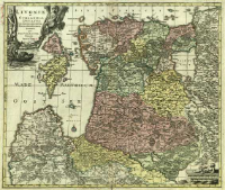
Title: Livoniæ et Curlandiæ Ducatus cum Insulis Adjacentib. Mappa Geographica
Subtitle:
Livoniae et Curlandiae Ducatus cum Insulis Adjacentib. Mappa Geographica
Contributor:
Lotter, Tobias Conrad (1717–1777) : Wyd. ; Drentwett, Abraham. (1647–1729) : Ryt.
Publisher:
exhibiti per Tob. Conr. Lotter
Place of publishing:
Description:
Skala [ca 1:930 000] ; 1 mapa : miedzior., kolor. ręcznie ; 48x57 cm ; Pod dolną ramką adnot.: Cum Gratia et Privil. S. R. I. Vicariatus in partib. Rheni, Sveviæ, et Juris Franconici ; Południk zerowy Ferro ; Mapa wyd. po 1757 r. przez T. C. Lottera pod własnym nazwiskiem z płyty miedzior. odziedziczonej po śmierci M. G. Seuttera - ślady zatarcia nazwiska Seuttera. Mapa samoistna oraz zamieszczana w atlasach wydawanych przez T. C. Lottera, m.in. w: Atlas novus sive tabulae geograficae totius orbis faciem, partes, imperia regna et provincias exhibentes [...]. - Augustae Vindelicorum, [ca 1780]
Detailed Resource Type:
Format:
Resource Identifier:
Source:
CBGiOŚ. IGiPZ PAN, sygn. Ds.8243 [I.6C-4] ; click here to follow the link
Language:
Rights:
Terms of use:
Digitizing institution:
Instytut Geografii i Przestrzennego Zagospodarowania Polskiej Akademii Nauk
Original in:
Projects co-financed by:
Program Operacyjny Innowacyjna Gospodarka, lata 2010-2014, Priorytet 2. Infrastruktura strefy B + R ; Unia Europejska. Europejski Fundusz Rozwoju Regionalnego
Access:
Object collections:
- Digital Repository of Scientific Institutes > Partners' collections > Institute of Geography and Spatial Organization PAS (IGiPZ PAN) > Library
- Digital Repository of Scientific Institutes > Partners' collections > Institute of Geography and Spatial Organization PAS (IGiPZ PAN) > Library > Maps and atlases
- Digital Repository of Scientific Institutes > Literature > Maps/Atlases
Last modified:
Oct 2, 2020
In our library since:
Jan 30, 2014
Number of object content downloads / hits:
96
All available object's versions:
https://rcin.org.pl./publication/51463
Show description in RDF format:
Show description in RDFa format:
Show description in OAI-PMH format:
Objects Similar
Pfau, Theodor Philipp (1725–1794) Glassbach, Christian Benjamin (1724–1779)


