- Search in all Repository
- Literature and maps
- Archeology
- Mills database
- Natural sciences
Advanced search
Advanced search
Advanced search
Advanced search
Advanced search

Object
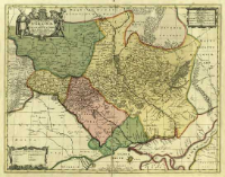
Title: Typus Generalis Ukrainae sive Palatinatuum Podoliae, Kioviensis et Braczlaviensis terras nova delineatione exhibens
Subtitle:
Contributor:
Pitt, Moses (1641–1697) : Wyd. ; Janssonius Van Waesberge Officina
Publisher:
Ex Officina Janssonis-Waesbergiana ; et Mossis Pitt
Place of publishing:
Description:
Skala [ca 1:1 800 000] ; 1 mapa : miedzior, kolor. ręcznie. ; 43x54 cm, na ark. 53x61 cm ; W prawym górnym rogu sześć podziałek liniowych. Na mapie umieszczono 2 noty historyczne, pod górną ramką nota o bitwie pod Łojowem w 1649 r. i drugi o Bitwie pod Beresteczkiem z 1651 r. W lewym dolnym rogu mapy kartusz z legendą: Signorum vel Characterum declaratio ; Południk zerowy Ferro ; Nad dolną ramką pośrodku nota wydawnicza: Ex Officina Janssonic - Waesbergiana ; et Mosis Pitt ; Kartusz tyt. w lewym górnym rogu mapy. Kartusz w otoczniu 4 postaci, zwieńczony tarczą z herbem Polski pod koroną ; Między ramkami opisane s. świata: Septentrio, Meridies, Oriens, Occidens ; W lewym górnym rogu page: XII ; Jest to drugi stan mapy, zamieszczony w: The English Atlas. Vol. 1., containing a description of the places next the North Pole, as also of Moscovy, Poland, Sveden, Denmark [...]. - Oxford : M. Pitt, 1680 ; Cyt.: BNPol online ; Cyt.: Imago Poloniae. - 2002, poz. K95/2, s. 201
Detailed Resource Type:
Format:
Resource Identifier:
Source:
CBGiOŚ. IGiPZ PAN, call no. D.1962 [I.7E-1] ; click here to follow the link
Language:
Rights:
Terms of use:
Digitizing institution:
Institute of Geography and Spatial Organization of the Polish Academy of Sciences
Original in:
Projects co-financed by:
Programme Innovative Economy, 2010-2014, Priority Axis 2. R&D infrastructure ; European Union. European Regional Development Fund
Access:
Object collections:
- Digital Repository of Scientific Institutes > Partners' collections > Institute of Geography and Spatial Organization PAS (IGiPZ PAN) > Library
- Digital Repository of Scientific Institutes > Partners' collections > Institute of Geography and Spatial Organization PAS (IGiPZ PAN) > Library > Maps and atlases
- Digital Repository of Scientific Institutes > Literature > Maps/Atlases
Last modified:
Oct 2, 2020
In our library since:
Jan 30, 2014
Number of object content downloads / hits:
243
All available object's versions:
https://rcin.org.pl./publication/51407
Show description in RDF format:
Show description in RDFa format:
Show description in OAI-PMH format:
Objects Similar
Beauplan, Guillaume Le Vasseur de (c. 1600 – 1675)
Beauplan, Guillaume Le Vasseur de (c. 1600 – 1675)
Cieszyńska, Beata Żukowska, Maria Helena Giebułtowski, Jerzy
Janssonius, Johannes (1588–1664) Pitt, Moses (1641–1697) Janssonius Van Waesberge Officina

 INSTYTUT ARCHEOLOGII I ETNOLOGII POLSKIEJ AKADEMII NAUK
 INSTYTUT BADAŃ LITERACKICH POLSKIEJ AKADEMII NAUK
 INSTYTUT BADAWCZY LEŚNICTWA
 INSTYTUT BIOLOGII DOŚWIADCZALNEJ IM. MARCELEGO NENCKIEGO POLSKIEJ AKADEMII NAUK
 INSTYTUT BIOLOGII SSAKÓW POLSKIEJ AKADEMII NAUK
 INSTYTUT CHEMII FIZYCZNEJ PAN
 INSTYTUT CHEMII ORGANICZNEJ PAN
 INSTYTUT FILOZOFII I SOCJOLOGII PAN
 INSTYTUT GEOGRAFII I PRZESTRZENNEGO ZAGOSPODAROWANIA PAN
 INSTYTUT HISTORII im. TADEUSZA MANTEUFFLA POLSKIEJ AKADEMII NAUK
 INSTYTUT JĘZYKA POLSKIEGO POLSKIEJ AKADEMII NAUK
 INSTYTUT MATEMATYCZNY PAN
 INSTYTUT MEDYCYNY DOŚWIADCZALNEJ I KLINICZNEJ IM.MIROSŁAWA MOSSAKOWSKIEGO POLSKIEJ AKADEMII NAUK
 INSTYTUT PODSTAWOWYCH PROBLEMÓW TECHNIKI PAN
 INSTYTUT SLAWISTYKI PAN
 SIEĆ BADAWCZA ŁUKASIEWICZ - INSTYTUT TECHNOLOGII MATERIAŁÓW ELEKTRONICZNYCH
 MUZEUM I INSTYTUT ZOOLOGII POLSKIEJ AKADEMII NAUK
 INSTYTUT BADAŃ SYSTEMOWYCH PAN
 INSTYTUT BOTANIKI IM. WŁADYSŁAWA SZAFERA POLSKIEJ AKADEMII NAUK


