- O repozytorium
- Kolekcje
- Indeksy
- Historia przeglądania
-
Repozytoria RCIN
-
 INSTYTUT ARCHEOLOGII I ETNOLOGII POLSKIEJ AKADEMII NAUK
-
 INSTYTUT BADAŃ LITERACKICH POLSKIEJ AKADEMII NAUK
-
 INSTYTUT BADAWCZY LEŚNICTWA
-
 INSTYTUT BIOLOGII DOŚWIADCZALNEJ IM. MARCELEGO NENCKIEGO POLSKIEJ AKADEMII NAUK
-
 INSTYTUT BIOLOGII SSAKÓW POLSKIEJ AKADEMII NAUK
-
 INSTYTUT CHEMII FIZYCZNEJ PAN
-
 INSTYTUT CHEMII ORGANICZNEJ PAN
-
 INSTYTUT FILOZOFII I SOCJOLOGII PAN
-
 INSTYTUT GEOGRAFII I PRZESTRZENNEGO ZAGOSPODAROWANIA PAN
-
 INSTYTUT HISTORII im. TADEUSZA MANTEUFFLA POLSKIEJ AKADEMII NAUK
-
 INSTYTUT JĘZYKA POLSKIEGO POLSKIEJ AKADEMII NAUK
-
 INSTYTUT MATEMATYCZNY PAN
-
 INSTYTUT MEDYCYNY DOŚWIADCZALNEJ I KLINICZNEJ IM.MIROSŁAWA MOSSAKOWSKIEGO POLSKIEJ AKADEMII NAUK
-
 INSTYTUT PODSTAWOWYCH PROBLEMÓW TECHNIKI PAN
-
 INSTYTUT SLAWISTYKI PAN
-
 SIEĆ BADAWCZA ŁUKASIEWICZ - INSTYTUT TECHNOLOGII MATERIAŁÓW ELEKTRONICZNYCH
-
 MUZEUM I INSTYTUT ZOOLOGII POLSKIEJ AKADEMII NAUK
-
 INSTYTUT BADAŃ SYSTEMOWYCH PAN
-
 INSTYTUT BOTANIKI IM. WŁADYSŁAWA SZAFERA POLSKIEJ AKADEMII NAUK
-
- Wyszukaj w całym Repozytorium
- Piśmiennictwo i mapy
- Archeologia
- Baza Młynów
- Nauki przyrodnicze
Wyszukiwanie zaawansowane
Wyszukiwanie zaawansowane
Wyszukiwanie zaawansowane
Wyszukiwanie zaawansowane
Wyszukiwanie zaawansowane

Obiekt
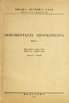
Tytuł: Stan pokrycia obszaru Polski materiałami kartograficznymi
Inny tytuł:
Dokumentacja Geograficzna 1955 z. 10
Wydawca:
Miejsce wydania:
Opis:
[2], 47 s., [10] k. tabl. : il. ; 30 cm
Typ obiektu:
Czasopismo/Seria/cykl:
Szczegółowy typ zasobu:
Format:
Rozmiar pliku 12,4 MB ; application/pdf
Identyfikator zasobu:
Źródło:
CBGiOŚ. IGiPZ PAN, sygn. Cz.944[1955, z.10] ; CBGiOŚ. IGiPZ PAN, sygn. Cz.5709[1955, z.10] ; CBGiOŚ. IGiPZ PAN, sygn. Cz.5711[1955, z.10] ; kliknij tutaj, żeby przejść
Język:
Prawa:
Prawa zastrzeżone - dostęp nieograniczony
Zasady wykorzystania:
Digitalizacja:
Instytut Geografii i Przestrzennego Zagospodarowania Polskiej Akademii Nauk
Lokalizacja oryginału:
Dofinansowane ze środków:
Program Operacyjny Innowacyjna Gospodarka, lata 2010-2014, Priorytet 2. Infrastruktura strefy B + R ; Unia Europejska. Europejski Fundusz Rozwoju Regionalnego
Dostęp:
Kolekcje, do których przypisany jest obiekt:
- Repozytorium Cyfrowe Instytutów Naukowych > Kolekcje Partnerów > Instytut Geografii i Przestrzennego Zagospodarowania PAN > Publikacje pracowników i Wydawnictw
- Repozytorium Cyfrowe Instytutów Naukowych > Kolekcje Partnerów > Instytut Geografii i Przestrzennego Zagospodarowania PAN > Biblioteka Instytutu > Książki
- Repozytorium Cyfrowe Instytutów Naukowych > Kolekcje Partnerów > Instytut Geografii i Przestrzennego Zagospodarowania PAN > Biblioteka Instytutu > Serie/Czasopisma/Cykle
- Repozytorium Cyfrowe Instytutów Naukowych > Piśmiennictwo > Książki/Rozdziały
Data ostatniej modyfikacji:
2 paź 2020
Data dodania obiektu:
9 sie 2014
Liczba pobrań / odtworzeń:
5128
Wszystkie dostępne wersje tego obiektu:
https://rcin.org.pl./publication/50660
Wyświetl opis w formacie RDF:
Wyświetl opis w formacie RDFa:
Wyświetl opis w formacie OAI-PMH:
| Nazwa wydania | Data |
|---|---|
| z. 10 (1955) : Stan pokrycia obszaru Polski materiałami kartograficznymi | 2 paź 2020 |
Obiekty Podobne
Ostrowski, Jerzy (1938– )
Gawryszewski, Andrzej (1939– )
Danysz-Fleszarowa, Regina Zofia (1888–1969)
Panecki, Tomasz


