- About project
- Collections
- Indexes
- Recently viewed
-
RCIN Repositories
-
 INSTYTUT ARCHEOLOGII I ETNOLOGII POLSKIEJ AKADEMII NAUK
-
 INSTYTUT BADAŃ LITERACKICH POLSKIEJ AKADEMII NAUK
-
 INSTYTUT BADAWCZY LEŚNICTWA
-
 INSTYTUT BIOLOGII DOŚWIADCZALNEJ IM. MARCELEGO NENCKIEGO POLSKIEJ AKADEMII NAUK
-
 INSTYTUT BIOLOGII SSAKÓW POLSKIEJ AKADEMII NAUK
-
 INSTYTUT CHEMII FIZYCZNEJ PAN
-
 INSTYTUT CHEMII ORGANICZNEJ PAN
-
 INSTYTUT FILOZOFII I SOCJOLOGII PAN
-
 INSTYTUT GEOGRAFII I PRZESTRZENNEGO ZAGOSPODAROWANIA PAN
-
 INSTYTUT HISTORII im. TADEUSZA MANTEUFFLA POLSKIEJ AKADEMII NAUK
-
 INSTYTUT JĘZYKA POLSKIEGO POLSKIEJ AKADEMII NAUK
-
 INSTYTUT MATEMATYCZNY PAN
-
 INSTYTUT MEDYCYNY DOŚWIADCZALNEJ I KLINICZNEJ IM.MIROSŁAWA MOSSAKOWSKIEGO POLSKIEJ AKADEMII NAUK
-
 INSTYTUT PODSTAWOWYCH PROBLEMÓW TECHNIKI PAN
-
 INSTYTUT SLAWISTYKI PAN
-
 SIEĆ BADAWCZA ŁUKASIEWICZ - INSTYTUT TECHNOLOGII MATERIAŁÓW ELEKTRONICZNYCH
-
 MUZEUM I INSTYTUT ZOOLOGII POLSKIEJ AKADEMII NAUK
-
 INSTYTUT BADAŃ SYSTEMOWYCH PAN
-
 INSTYTUT BOTANIKI IM. WŁADYSŁAWA SZAFERA POLSKIEJ AKADEMII NAUK
-

Object
Building
Typ zasobu:
Nazwa:
Inne nazwy:
Typ obiektu:
Lokalizacja-położenie administracyjne(współczesne):
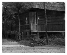
Murzasichle, tatrzański district, Lesser Poland voivodeship
Lokalizacja- położenie administracyjne (dawne):
Murzasichle, Nowy Targ district, Kraków voivodeship
Lokalizacja- położenie topograficzne:
Zobacz na mapie:
Opis obiektu:
Autor (rysunku, zdjęcia, rekordu):
Data badań:
Numer inwentarzowy:
Uwagi:
Photo negative no. F 191/57/1/P 23 (24)
Czasopismo/Seria/cykl:
Szczegółowy typ zasobu:
Identyfikator zasobu:
Prawa:
Zasady wykorzystania:
Digitalizacja:
Institute of Archaeology and Ethnology of the Polish Academy of Sciences
Lokalizacja oryginału:
Institute of Archaeology and Ethnology of the Polish Academy of Sciences
Dofinansowane ze środków:
Operational Program Digital Poland, 2014-2020, Measure 2.3: Digital accessibility and usefulness of public sector information; funds from the European Regional Development Fund and national co-financing from the state budget. ; European Union. European Regional Development Fund
Dostęp:
Object collections:
- Repozytorium Cyfrowe Instytutów Naukowych > Kolekcje Partnerów > Instytut Archeologii i Etnologii PAN > Materiały etnograficzne > Polski Atlas Etnograficzny
- Repozytorium Cyfrowe Instytutów Naukowych > Dane i obiekty naukowe > Nauki humanistyczne i społeczne > Kolekcje z zakresu antropologii kultury
Last modified:
Oct 27, 2022
In our library since:
Sep 28, 2021
Number of object content downloads / hits:
14
All available object's versions:
https://rcin.org.pl./publication/249676
Show description in RDF format:
Show description in RDFa format:
Show description in OAI-PMH format:
| Edition name | Date |
|---|---|
| Budynek | Oct 27, 2022 |


