- About project
- Collections
- Indexes
- Recently viewed
-
RCIN Repositories
-
 INSTYTUT ARCHEOLOGII I ETNOLOGII POLSKIEJ AKADEMII NAUK
-
 INSTYTUT BADAŃ LITERACKICH POLSKIEJ AKADEMII NAUK
-
 INSTYTUT BADAWCZY LEŚNICTWA
-
 INSTYTUT BIOLOGII DOŚWIADCZALNEJ IM. MARCELEGO NENCKIEGO POLSKIEJ AKADEMII NAUK
-
 INSTYTUT BIOLOGII SSAKÓW POLSKIEJ AKADEMII NAUK
-
 INSTYTUT CHEMII FIZYCZNEJ PAN
-
 INSTYTUT CHEMII ORGANICZNEJ PAN
-
 INSTYTUT FILOZOFII I SOCJOLOGII PAN
-
 INSTYTUT GEOGRAFII I PRZESTRZENNEGO ZAGOSPODAROWANIA PAN
-
 INSTYTUT HISTORII im. TADEUSZA MANTEUFFLA POLSKIEJ AKADEMII NAUK
-
 INSTYTUT JĘZYKA POLSKIEGO POLSKIEJ AKADEMII NAUK
-
 INSTYTUT MATEMATYCZNY PAN
-
 INSTYTUT MEDYCYNY DOŚWIADCZALNEJ I KLINICZNEJ IM.MIROSŁAWA MOSSAKOWSKIEGO POLSKIEJ AKADEMII NAUK
-
 INSTYTUT PODSTAWOWYCH PROBLEMÓW TECHNIKI PAN
-
 INSTYTUT SLAWISTYKI PAN
-
 SIEĆ BADAWCZA ŁUKASIEWICZ - INSTYTUT TECHNOLOGII MATERIAŁÓW ELEKTRONICZNYCH
-
 MUZEUM I INSTYTUT ZOOLOGII POLSKIEJ AKADEMII NAUK
-
 INSTYTUT BADAŃ SYSTEMOWYCH PAN
-
 INSTYTUT BOTANIKI IM. WŁADYSŁAWA SZAFERA POLSKIEJ AKADEMII NAUK
-
- Search in all Repository
- Literature and maps
- Archeology
- Mills database
- Natural sciences
Advanced search
Advanced search
Advanced search
Advanced search
Advanced search

Object
Available formats:
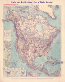
Download allTitle: Karte von Nord-Amerika (Map of North America) aus Sohr-Berghaus' Handatlas
Creator:
Bludau, Alois (1861–1913) : Redaktor ; Herkt, Otto (1885–1925) : Redaktor
Date issued/created:
Resource type:
Subtitle:
Flemmings namentreue (idionomatographische) Länderkarten ; Blatt 5 ; Map of North America
Institutional creator:
Carl Flemming Verlag, Buch- und Kunstdruckerei (Głogów).
Publisher:
Carl Flemming, Verlag, Buch- und Kunstdruckerei, A.G.
Place of publishing:
Description:
Skala 1:10 000 000 ; 1 mapa : kolorowa ; 84 x 71 cm, na arkuszu 97 x 79 cm ; Mapy poboczne: Politische Übersicht Maßstab - 1:80 Mill. ; Bevölkerungsdichte Maßstab - 1:80 Mill. ; Vegetationsgebiete ; Fischerei und Viehzucht (die wichtigsten Gebiete) ; Bergbau, Holz- und Kautschuk-Industrie ; Pflanzenbau (die wichtigsten Gebiete) ; Panamá-Kanal Maßstab - 1:1 Mill. ; Die Aleuten iim Maßstab e der Hauptkarte ; [Sandwich Is., Mariana Is., Samoa Islands] Maßstab - 1:10 Mill. (wie Hauptkarte) ; Zum Vergleich im Maßstab der Hauptkarte ; Tytuł i informacje pozaramkowe w języku niemieckim, nazwy geograficzne na mapie w języku angielskim, część także w języku niemieckim i hiszpańskim.
Relation:
Flemmings namentreue (idionomatographische) Länderkarten
Detailed Resource Type:
Resource Identifier:
Source:
CBGiOŚ. IGiPZ PAN, sygn. D.11818 ; click here to follow the link
Language:
Coverage:
Rights:
Terms of use:
Digitizing institution:
Instytut Geografii i Przestrzennego Zagospodarowania Polskiej Akademii Nauk
Original in:
Projects co-financed by:
Access:
Object collections:
- Digital Repository of Scientific Institutes > Partners' collections > Institute of Geography and Spatial Organization PAS (IGiPZ PAN)
- Digital Repository of Scientific Institutes > Partners' collections > Institute of Geography and Spatial Organization PAS (IGiPZ PAN) > Library
- Digital Repository of Scientific Institutes > Partners' collections > Institute of Geography and Spatial Organization PAS (IGiPZ PAN) > Library > Maps and atlases
- Digital Repository of Scientific Institutes > Literature > Maps/Atlases
Last modified:
Oct 20, 2021
In our library since:
Oct 18, 2021
Number of object content downloads / hits:
48
All available object's versions:
https://rcin.org.pl./publication/225054
Show description in RDF format:
Show description in RDFa format:
Show description in OAI-PMH format:
| Edition name | Date |
|---|---|
| Karte von Nord-Amerika (Map of North America) aus Sohr-Berghaus' Handatlas, [między 1910 i 1919] | Oct 20, 2021 |
Objects Similar
Kettler, Julius Iwan (1852–1921) Bludau, Alois (1861–1913) Herkt, Otto (1885–1925) Hoch, C. Melching, Oswald
Visscher, Nicolaes (1618–1679)
Lapie, Pierre (1779–1850) Tardieu, Antoine-François (1757–1822) Pachoux, J. J. (17..-18..). Ryt.
Hase, Johann Matthias (1684–1742) Böhme, August Gottlob (1719–1797)


