- O repozytorium
- Kolekcje
- Indeksy
- Historia przeglądania
-
Repozytoria RCIN
-
 INSTYTUT ARCHEOLOGII I ETNOLOGII POLSKIEJ AKADEMII NAUK
-
 INSTYTUT BADAŃ LITERACKICH POLSKIEJ AKADEMII NAUK
-
 INSTYTUT BADAWCZY LEŚNICTWA
-
 INSTYTUT BIOLOGII DOŚWIADCZALNEJ IM. MARCELEGO NENCKIEGO POLSKIEJ AKADEMII NAUK
-
 INSTYTUT BIOLOGII SSAKÓW POLSKIEJ AKADEMII NAUK
-
 INSTYTUT CHEMII FIZYCZNEJ PAN
-
 INSTYTUT CHEMII ORGANICZNEJ PAN
-
 INSTYTUT FILOZOFII I SOCJOLOGII PAN
-
 INSTYTUT GEOGRAFII I PRZESTRZENNEGO ZAGOSPODAROWANIA PAN
-
 INSTYTUT HISTORII im. TADEUSZA MANTEUFFLA POLSKIEJ AKADEMII NAUK
-
 INSTYTUT JĘZYKA POLSKIEGO POLSKIEJ AKADEMII NAUK
-
 INSTYTUT MATEMATYCZNY PAN
-
 INSTYTUT MEDYCYNY DOŚWIADCZALNEJ I KLINICZNEJ IM.MIROSŁAWA MOSSAKOWSKIEGO POLSKIEJ AKADEMII NAUK
-
 INSTYTUT PODSTAWOWYCH PROBLEMÓW TECHNIKI PAN
-
 INSTYTUT SLAWISTYKI PAN
-
 SIEĆ BADAWCZA ŁUKASIEWICZ - INSTYTUT TECHNOLOGII MATERIAŁÓW ELEKTRONICZNYCH
-
 MUZEUM I INSTYTUT ZOOLOGII POLSKIEJ AKADEMII NAUK
-
 INSTYTUT BADAŃ SYSTEMOWYCH PAN
-
 INSTYTUT BOTANIKI IM. WŁADYSŁAWA SZAFERA POLSKIEJ AKADEMII NAUK
-
- Wyszukaj w całym Repozytorium
- Piśmiennictwo i mapy
- Archeologia
- Baza Młynów
- Nauki przyrodnicze
Wyszukiwanie zaawansowane
Wyszukiwanie zaawansowane
Wyszukiwanie zaawansowane
Wyszukiwanie zaawansowane
Wyszukiwanie zaawansowane

Obiekt
Dostępne formaty:
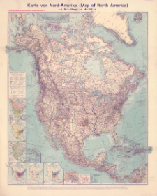
Pobierz wszystkieTytuł: Karte von Nord-Amerika (Map of North America) aus Sohr-Berghaus' Handatlas
Twórca:
Bludau, Alois (1861–1913) : Redaktor ; Herkt, Otto (1885–1925) : Redaktor
Data wydania/powstania:
Typ zasobu:
Inny tytuł:
Flemmings namentreue (idionomatographische) Länderkarten ; Blatt 5 ; Map of North America
Twórca instytucjonalny:
Carl Flemming Verlag, Buch- und Kunstdruckerei (Głogów).
Wydawca:
Carl Flemming, Verlag, Buch- und Kunstdruckerei, A.G.
Miejsce wydania:
Opis:
Skala 1:10 000 000 ; 1 mapa : kolorowa ; 84 x 71 cm, na arkuszu 97 x 79 cm ; Mapy poboczne: Politische Übersicht Maßstab - 1:80 Mill. ; Bevölkerungsdichte Maßstab - 1:80 Mill. ; Vegetationsgebiete ; Fischerei und Viehzucht (die wichtigsten Gebiete) ; Bergbau, Holz- und Kautschuk-Industrie ; Pflanzenbau (die wichtigsten Gebiete) ; Panamá-Kanal Maßstab - 1:1 Mill. ; Die Aleuten iim Maßstab e der Hauptkarte ; [Sandwich Is., Mariana Is., Samoa Islands] Maßstab - 1:10 Mill. (wie Hauptkarte) ; Zum Vergleich im Maßstab der Hauptkarte ; Tytuł i informacje pozaramkowe w języku niemieckim, nazwy geograficzne na mapie w języku angielskim, część także w języku niemieckim i hiszpańskim.
Czasopismo/Seria/cykl:
Flemmings namentreue (idionomatographische) Länderkarten
Szczegółowy typ zasobu:
Identyfikator zasobu:
Źródło:
CBGiOŚ. IGiPZ PAN, sygn. D.11818 ; kliknij tutaj, żeby przejść
Język:
Zakres:
Prawa:
Zasady wykorzystania:
Digitalizacja:
Instytut Geografii i Przestrzennego Zagospodarowania Polskiej Akademii Nauk
Lokalizacja oryginału:
Dofinansowane ze środków:
Dostęp:
Kolekcje, do których przypisany jest obiekt:
- Repozytorium Cyfrowe Instytutów Naukowych > Kolekcje Partnerów > Instytut Geografii i Przestrzennego Zagospodarowania PAN
- Repozytorium Cyfrowe Instytutów Naukowych > Kolekcje Partnerów > Instytut Geografii i Przestrzennego Zagospodarowania PAN > Biblioteka Instytutu
- Repozytorium Cyfrowe Instytutów Naukowych > Kolekcje Partnerów > Instytut Geografii i Przestrzennego Zagospodarowania PAN > Biblioteka Instytutu > Mapy i atlasy
- Repozytorium Cyfrowe Instytutów Naukowych > Piśmiennictwo > Mapy/Atlasy
Data ostatniej modyfikacji:
20 paź 2021
Data dodania obiektu:
18 paź 2021
Liczba pobrań / odtworzeń:
54
Wszystkie dostępne wersje tego obiektu:
https://rcin.org.pl./publication/225054
Wyświetl opis w formacie RDF:
Wyświetl opis w formacie RDFa:
Wyświetl opis w formacie OAI-PMH:
| Nazwa wydania | Data |
|---|---|
| Karte von Nord-Amerika (Map of North America) aus Sohr-Berghaus' Handatlas, [między 1910 i 1919] | 20 paź 2021 |
Obiekty Podobne
Kettler, Julius Iwan (1852–1921) Bludau, Alois (1861–1913) Herkt, Otto (1885–1925) Hoch, C. Melching, Oswald
Visscher, Nicolaes (1618–1679)
Lapie, Pierre (1779–1850) Tardieu, Antoine-François (1757–1822) Pachoux, J. J. (17..-18..). Ryt.
Hase, Johann Matthias (1684–1742) Böhme, August Gottlob (1719–1797)


