- Search in all Repository
- Literature and maps
- Archeology
- Mills database
- Natural sciences
Advanced search
Advanced search
Advanced search
Advanced search
Advanced search

Object
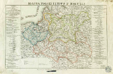
Title: Mappa Polski i Litwy z roku 1772
Subtitle:
Mapa Polski i Litwy z roku 1772
Publisher:
wyryta przy Liceum Warszawskim
Place of publishing:
Description:
Scale [ca 1:2 846 000] ; 1 map : copperplate engraving, hand col. ; 31x50 cm ; On the sheet margin there are tables with administrative division of Poland and Lithuania in 1772
Detailed Resource Type:
Format:
Resource Identifier:
Source:
CBGiOŚ. IGiPZ PAN, call no. D.1808 [I.2A-14] ; click here to follow the link
Language:
Rights:
Terms of use:
Digitizing institution:
Institute of Geography and Spatial Organization of the Polish Academy of Sciences
Original in:
Projects co-financed by:
Programme Innovative Economy, 2010-2014, Priority Axis 2. R&D infrastructure ; European Union. European Regional Development Fund
Access:
Object collections:
- Digital Repository of Scientific Institutes > Partners' collections > Institute of Geography and Spatial Organization PAS (IGiPZ PAN) > Library
- Digital Repository of Scientific Institutes > Partners' collections > Institute of Geography and Spatial Organization PAS (IGiPZ PAN) > Library > Maps and atlases
- Digital Repository of Scientific Institutes > Literature > Maps/Atlases
Last modified:
Oct 2, 2020
In our library since:
Aug 22, 2011
Number of object content downloads / hits:
410
All available object's versions:
https://rcin.org.pl./publication/1976
Show description in RDF format:
Show description in RDFa format:
Show description in OAI-PMH format:
| Edition name | Date |
|---|---|
| Mappa Polski i Litwy z roku 1772 wyryta z poprawą przez Seweryna Oleszczyńskiego. | Oct 2, 2020 |
Objects Similar
Schraembl, Franz Anton (1751–1803) Benedicti, Hieronymus (1756–1809)
Homann, Johann Baptist (1664–1724)
Homann, Johann Baptist (1664–1724)
Jarry de Mancy, Adrien (1782–1842) Alès, Auguste Francois (1798–1878) Las Cases, Emmanuel de (1766–1842)
Jarry de Mancy, Adrien (1782–1842) Las Cases, Emmanuel de (1766–1842)
Esquisse chronologique des révolutions nationales de Pologne (méthode de Le Sage, C.te de Las Cases)
Jarry de Mancy, Adrien (1782–1842) Alès, Auguste Francois (1798–1878) Las Cases, Emmanuel de (1766–1842)
Vil'breht, Aleksandr Mihajlovič (1756–1823) Ušakov, K. Rys.

 INSTYTUT ARCHEOLOGII I ETNOLOGII POLSKIEJ AKADEMII NAUK
 INSTYTUT BADAŃ LITERACKICH POLSKIEJ AKADEMII NAUK
 INSTYTUT BADAWCZY LEŚNICTWA
 INSTYTUT BIOLOGII DOŚWIADCZALNEJ IM. MARCELEGO NENCKIEGO POLSKIEJ AKADEMII NAUK
 INSTYTUT BIOLOGII SSAKÓW POLSKIEJ AKADEMII NAUK
 INSTYTUT CHEMII FIZYCZNEJ PAN
 INSTYTUT CHEMII ORGANICZNEJ PAN
 INSTYTUT FILOZOFII I SOCJOLOGII PAN
 INSTYTUT GEOGRAFII I PRZESTRZENNEGO ZAGOSPODAROWANIA PAN
 INSTYTUT HISTORII im. TADEUSZA MANTEUFFLA POLSKIEJ AKADEMII NAUK
 INSTYTUT JĘZYKA POLSKIEGO POLSKIEJ AKADEMII NAUK
 INSTYTUT MATEMATYCZNY PAN
 INSTYTUT MEDYCYNY DOŚWIADCZALNEJ I KLINICZNEJ IM.MIROSŁAWA MOSSAKOWSKIEGO POLSKIEJ AKADEMII NAUK
 INSTYTUT PODSTAWOWYCH PROBLEMÓW TECHNIKI PAN
 INSTYTUT SLAWISTYKI PAN
 SIEĆ BADAWCZA ŁUKASIEWICZ - INSTYTUT TECHNOLOGII MATERIAŁÓW ELEKTRONICZNYCH
 MUZEUM I INSTYTUT ZOOLOGII POLSKIEJ AKADEMII NAUK
 INSTYTUT BADAŃ SYSTEMOWYCH PAN
 INSTYTUT BOTANIKI IM. WŁADYSŁAWA SZAFERA POLSKIEJ AKADEMII NAUK


