- O repozytorium
- Kolekcje
- Indeksy
- Historia przeglądania
-
Repozytoria RCIN
-
 INSTYTUT ARCHEOLOGII I ETNOLOGII POLSKIEJ AKADEMII NAUK
-
 INSTYTUT BADAŃ LITERACKICH POLSKIEJ AKADEMII NAUK
-
 INSTYTUT BADAWCZY LEŚNICTWA
-
 INSTYTUT BIOLOGII DOŚWIADCZALNEJ IM. MARCELEGO NENCKIEGO POLSKIEJ AKADEMII NAUK
-
 INSTYTUT BIOLOGII SSAKÓW POLSKIEJ AKADEMII NAUK
-
 INSTYTUT CHEMII FIZYCZNEJ PAN
-
 INSTYTUT CHEMII ORGANICZNEJ PAN
-
 INSTYTUT FILOZOFII I SOCJOLOGII PAN
-
 INSTYTUT GEOGRAFII I PRZESTRZENNEGO ZAGOSPODAROWANIA PAN
-
 INSTYTUT HISTORII im. TADEUSZA MANTEUFFLA POLSKIEJ AKADEMII NAUK
-
 INSTYTUT JĘZYKA POLSKIEGO POLSKIEJ AKADEMII NAUK
-
 INSTYTUT MATEMATYCZNY PAN
-
 INSTYTUT MEDYCYNY DOŚWIADCZALNEJ I KLINICZNEJ IM.MIROSŁAWA MOSSAKOWSKIEGO POLSKIEJ AKADEMII NAUK
-
 INSTYTUT PODSTAWOWYCH PROBLEMÓW TECHNIKI PAN
-
 INSTYTUT SLAWISTYKI PAN
-
 SIEĆ BADAWCZA ŁUKASIEWICZ - INSTYTUT TECHNOLOGII MATERIAŁÓW ELEKTRONICZNYCH
-
 MUZEUM I INSTYTUT ZOOLOGII POLSKIEJ AKADEMII NAUK
-
 INSTYTUT BADAŃ SYSTEMOWYCH PAN
-
 INSTYTUT BOTANIKI IM. WŁADYSŁAWA SZAFERA POLSKIEJ AKADEMII NAUK
-
- Wyszukaj w całym Repozytorium
- Piśmiennictwo i mapy
- Archeologia
- Baza Młynów
- Nauki przyrodnicze
Wyszukiwanie zaawansowane
Wyszukiwanie zaawansowane
Wyszukiwanie zaawansowane
Wyszukiwanie zaawansowane
Wyszukiwanie zaawansowane

Obiekt
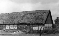
A barn
Typ zasobu:
Nazwa:
Inne nazwy:
Typ obiektu:
Lokalizacja-położenie administracyjne(współczesne):
Wilczyna, szamotulski district, Greater Poland voivodeship
Lokalizacja- położenie administracyjne (dawne):
Wilczyna, Szamotuły district, Poznań voivodeship
Lokalizacja- położenie topograficzne:
52° 28′ 56″ N, 16° 25′ 56.9″ E
Zobacz na mapie:
Opis obiektu:
The photo presents a half-timbered barn with a gable roof
Autor (rysunku, zdjęcia, rekordu):
Data badań:
Numer inwentarzowy:
Uwagi:
Photo negative no. F 1171/55/23/P 14 (6-13)
Czasopismo/Seria/cykl:
Szczegółowy typ zasobu:
Identyfikator zasobu:
Prawa:
Zasady wykorzystania:
Digitalizacja:
Institute of Archaeology and Ethnology of the Polish Academy of Sciences
Lokalizacja oryginału:
Institute of Archaeology and Ethnology of the Polish Academy of Sciences
Dofinansowane ze środków:
Operational Program Digital Poland, 2014-2020, Measure 2.3: Digital accessibility and usefulness of public sector information; funds from the European Regional Development Fund and national co-financing from the state budget. ; European Union. European Regional Development Fund
Dostęp:
Kolekcje, do których przypisany jest obiekt:
- Repozytorium Cyfrowe Instytutów Naukowych > Kolekcje Partnerów > Instytut Archeologii i Etnologii PAN > Materiały etnograficzne > Polski Atlas Etnograficzny
- Repozytorium Cyfrowe Instytutów Naukowych > Dane i obiekty naukowe > Nauki humanistyczne i społeczne > Kolekcje z zakresu antropologii kultury
Data ostatniej modyfikacji:
27 paź 2022
Data dodania obiektu:
22 sty 2021
Liczba pobrań / odtworzeń:
18
Wszystkie dostępne wersje tego obiektu:
https://rcin.org.pl./publication/190146
Wyświetl opis w formacie RDF:
Wyświetl opis w formacie RDFa:
Wyświetl opis w formacie OAI-PMH:
| Nazwa wydania | Data |
|---|---|
| Stodoła | 27 paź 2022 |


