- About project
- Collections
- Indexes
- Recently viewed
-
RCIN Repositories
-
 INSTYTUT ARCHEOLOGII I ETNOLOGII POLSKIEJ AKADEMII NAUK
-
 INSTYTUT BADAŃ LITERACKICH POLSKIEJ AKADEMII NAUK
-
 INSTYTUT BADAWCZY LEŚNICTWA
-
 INSTYTUT BIOLOGII DOŚWIADCZALNEJ IM. MARCELEGO NENCKIEGO POLSKIEJ AKADEMII NAUK
-
 INSTYTUT BIOLOGII SSAKÓW POLSKIEJ AKADEMII NAUK
-
 INSTYTUT CHEMII FIZYCZNEJ PAN
-
 INSTYTUT CHEMII ORGANICZNEJ PAN
-
 INSTYTUT FILOZOFII I SOCJOLOGII PAN
-
 INSTYTUT GEOGRAFII I PRZESTRZENNEGO ZAGOSPODAROWANIA PAN
-
 INSTYTUT HISTORII im. TADEUSZA MANTEUFFLA POLSKIEJ AKADEMII NAUK
-
 INSTYTUT JĘZYKA POLSKIEGO POLSKIEJ AKADEMII NAUK
-
 INSTYTUT MATEMATYCZNY PAN
-
 INSTYTUT MEDYCYNY DOŚWIADCZALNEJ I KLINICZNEJ IM.MIROSŁAWA MOSSAKOWSKIEGO POLSKIEJ AKADEMII NAUK
-
 INSTYTUT PODSTAWOWYCH PROBLEMÓW TECHNIKI PAN
-
 INSTYTUT SLAWISTYKI PAN
-
 SIEĆ BADAWCZA ŁUKASIEWICZ - INSTYTUT TECHNOLOGII MATERIAŁÓW ELEKTRONICZNYCH
-
 MUZEUM I INSTYTUT ZOOLOGII POLSKIEJ AKADEMII NAUK
-
 INSTYTUT BADAŃ SYSTEMOWYCH PAN
-
 INSTYTUT BOTANIKI IM. WŁADYSŁAWA SZAFERA POLSKIEJ AKADEMII NAUK
-
- Search in all Repository
- Literature and maps
- Archeology
- Mills database
- Natural sciences
Advanced search
Advanced search
Advanced search
Advanced search
Advanced search

Object
Available formats:
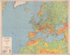
Download allTitle: Eur-Africa North : planning maps : scale 1:6,336,000
Creator:
Stany Zjednoczone. Army Map Service. Wydawca ; Stany Zjednoczone. Army. Office of the Chief Engineers. Redaktor
Date issued/created:
Resource type:
Publisher:
Place of publishing:
Description:
First edition- AMS 1 ; Skala 1:6 336 000 : Azimuthal equidistants projection based on London ; 1 mapa : kolorowa ; 93x116 cm, na arkuszu 96x122 cm ; W dolnym rogu mapy: Complied by the Army Map Service (GD), July 1943, from the following sources: Physical map of Canada 1:3,801,000 Canadian Department of Interior, 1928 Newfoundland 1:500,000 Sheets 1 and 2 AMS A401, 1943 Gronland 1:500,000 Danish Geodatisk Intitut, 1938 Iceland 1:1,000,000 Ground/Air GSGS 2758, AMS, 1942 GSGS 1:4,00,000 sheets 8 (1942), 19 (1936), 31A (1937) GSGS 2957 Asia 1:4,000,000 sheets 20 (1941), 21 91931), 32 (1941) GSGS 2957 Africa 1:2,000,000 sheets 6 (1943), 7 (1942), 8 (1942), 9 (1943), 10 (1943), 12 91942), 14 (1943), 15 (1942), 26 (1943) AMS 2201 British Admiralty Charts 1226, 1950 Faeroe Islands 1:1,000,000 AAF Aero Chart 106, AMS 1943 Sweden and Finland (North) 1:2,000,000 AMS, 1943 Sweden and Finland (South) 1:2,000,000 AMS 1943 Denmark 1:1,000,000 AMS, 1943 Germany 1:2,000,000 AMS, 1943 The Lowlands 1:1,000,000 AMS, 1943
Detailed Resource Type:
Format:
Resource Identifier:
Source:
CBGiOŚ. IGiPZ PAN, sygn. PTG D.441 ; click here to follow the link
Language:
Coverage:
Rights:
Terms of use:
Digitizing institution:
Instytut Geografii i Przestrzennego Zagospodarowania Polskiej Akademii Nauk
Original in:
Projects co-financed by:
Access:
Object collections:
- Digital Repository of Scientific Institutes > Partners' collections > Institute of Geography and Spatial Organization PAS (IGiPZ PAN) > Library > Maps and atlases
- Digital Repository of Scientific Institutes > Partners' collections > Institute of Geography and Spatial Organization PAS (IGiPZ PAN) > Library > Selected collections > Polish Geographical Society Collection
- Digital Repository of Scientific Institutes > Literature > Maps/Atlases
Last modified:
May 10, 2021
In our library since:
Dec 18, 2019
Number of object content downloads / hits:
133
All available object's versions:
https://rcin.org.pl./publication/94308
Show description in RDF format:
Show description in RDFa format:
Show description in OAI-PMH format:
| Edition name | Date |
|---|---|
| Eur-Africa North : planning maps : scale 1:6,336,000, 1943 | May 10, 2021 |
Objects Similar
Stany Zjednoczone. Army Map Service. Wydawca Stany Zjednoczone. Army. Office of the Chief Engineers. Redaktor
Gabrys, Juozas (1880–1951) Librairie centrale des nationalités (Lozannna). Wydawca Geographische Anstalt Kümmerly & Frey (Berno). Wydawca
Gross, Alexander (1879–1958) Geographia (Londyn). Wydawca
Stany Zjednoczone. Army Map Service. Wydawca
Challamel, Augustin (1819–1894) Imprimerie Monrocq
Stany Zjednoczone. Army Map Service. Redaktor. Wydawca Stany Zjednoczone. Army. Office of the Chief Engineers. Redaktor
Stany Zjednoczone. Army Map Service. Instytucja sprawcza. Wydawca Stany Zjednoczone. Army. Office of the Chief Engineers. Redaktor


