- O repozytorium
- Kolekcje
- Indeksy
- Historia przeglądania
-
Repozytoria RCIN
-
 INSTYTUT ARCHEOLOGII I ETNOLOGII POLSKIEJ AKADEMII NAUK
-
 INSTYTUT BADAŃ LITERACKICH POLSKIEJ AKADEMII NAUK
-
 INSTYTUT BADAWCZY LEŚNICTWA
-
 INSTYTUT BIOLOGII DOŚWIADCZALNEJ IM. MARCELEGO NENCKIEGO POLSKIEJ AKADEMII NAUK
-
 INSTYTUT BIOLOGII SSAKÓW POLSKIEJ AKADEMII NAUK
-
 INSTYTUT CHEMII FIZYCZNEJ PAN
-
 INSTYTUT CHEMII ORGANICZNEJ PAN
-
 INSTYTUT FILOZOFII I SOCJOLOGII PAN
-
 INSTYTUT GEOGRAFII I PRZESTRZENNEGO ZAGOSPODAROWANIA PAN
-
 INSTYTUT HISTORII im. TADEUSZA MANTEUFFLA POLSKIEJ AKADEMII NAUK
-
 INSTYTUT JĘZYKA POLSKIEGO POLSKIEJ AKADEMII NAUK
-
 INSTYTUT MATEMATYCZNY PAN
-
 INSTYTUT MEDYCYNY DOŚWIADCZALNEJ I KLINICZNEJ IM.MIROSŁAWA MOSSAKOWSKIEGO POLSKIEJ AKADEMII NAUK
-
 INSTYTUT PODSTAWOWYCH PROBLEMÓW TECHNIKI PAN
-
 INSTYTUT SLAWISTYKI PAN
-
 SIEĆ BADAWCZA ŁUKASIEWICZ - INSTYTUT TECHNOLOGII MATERIAŁÓW ELEKTRONICZNYCH
-
 MUZEUM I INSTYTUT ZOOLOGII POLSKIEJ AKADEMII NAUK
-
 INSTYTUT BADAŃ SYSTEMOWYCH PAN
-
 INSTYTUT BOTANIKI IM. WŁADYSŁAWA SZAFERA POLSKIEJ AKADEMII NAUK
-
- Wyszukaj w całym Repozytorium
- Piśmiennictwo i mapy
- Archeologia
- Baza Młynów
- Nauki przyrodnicze
Wyszukiwanie zaawansowane
Wyszukiwanie zaawansowane
Wyszukiwanie zaawansowane
Wyszukiwanie zaawansowane
Wyszukiwanie zaawansowane

Obiekt
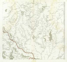
Tytuł: Regni Poloniae, Magni Ducatus Lituaniae Nova Mappa Geographica concessu Borussorum Regis. XX
Creator:
Pfau, Theodor Philipp (1725–1794) ; Glassbach, Christian Benjamin (1724–1779) : Ryt.
Date issued/created:
Resource type:
Publisher:
Place of publishing:
Description:
Scale [ca 1:525 000] ; 1 map : copperplate engraving ; 47x51 cm, sheet 52x58 cm ; Prime meridian [Ferro]
Type of object:
Detailed Resource Type:
Format:
File size 2,2 MB ; image/x.djvu
Resource Identifier:
Source:
CBGiOŚ. IGiPZ PAN, sygn. Ds.8702 [IX.2-m] ; kliknij tutaj, żeby przejść
Language:
Rights:
Terms of use:
Digitizing institution:
Institute of Geography and Spatial Organization of the Polish Academy of Sciences
Original in:
Projects co-financed by:
Programme Innovative Economy, 2010-2014, Priority Axis 2. R&D infrastructure ; European Union. European Regional Development Fund
Access:
Kolekcje, do których przypisany jest obiekt:
- Digital Repository of Scientific Institutes > Partners' collections > Institute of Geography and Spatial Organization PAS (IGiPZ PAN) > Library
- Digital Repository of Scientific Institutes > Partners' collections > Institute of Geography and Spatial Organization PAS (IGiPZ PAN) > Library > Maps and atlases
- Digital Repository of Scientific Institutes > Literature > Maps/Atlases
Data ostatniej modyfikacji:
Oct 2, 2020
Data dodania obiektu:
Nov 25, 2011
Liczba pobrań / odtworzeń:
145
Wszystkie dostępne wersje tego obiektu:
https://rcin.org.pl./publication/8966
Wyświetl opis w formacie RDF:
Wyświetl opis w formacie RDFa:
Wyświetl opis w formacie OAI-PMH:
| Nazwa wydania | Data |
|---|---|
| Regni Poloniae, Magni Ducatus Lituaniae Nova Mappa Geographica concessu Borussorum Regis. XX | Oct 2, 2020 |
Obiekty Podobne
Pfau, Theodor Philipp (1725–1794) Glassbach, Christian Benjamin (1724–1779)
Pfau, Theodor Philipp (1725–1794) Glassbach, Christian Benjamin (1724–1779)
Pfau, Theodor Philipp (1725–1794) Glassbach, Christian Benjamin (1724–1779)
Pfau, Theodor Philipp (1725–1794) Glassbach, Christian Benjamin (1724–1779)
Pfau, Theodor Philipp (1725–1794) Glassbach, Christian Benjamin (1724–1779)
Pfau, Theodor Philipp (1725–1794) Glassbach, Christian Benjamin (1724–1779)
Pfau, Theodor Philipp (1725–1794) Glassbach, Christian Benjamin (1724–1779)
Pfau, Theodor Philipp (1725–1794) Glassbach, Christian Benjamin (1724–1779)


