- About project
- Collections
- Indexes
- Recently viewed
-
RCIN Repositories
-
 INSTYTUT ARCHEOLOGII I ETNOLOGII POLSKIEJ AKADEMII NAUK
-
 INSTYTUT BADAŃ LITERACKICH POLSKIEJ AKADEMII NAUK
-
 INSTYTUT BADAWCZY LEŚNICTWA
-
 INSTYTUT BIOLOGII DOŚWIADCZALNEJ IM. MARCELEGO NENCKIEGO POLSKIEJ AKADEMII NAUK
-
 INSTYTUT BIOLOGII SSAKÓW POLSKIEJ AKADEMII NAUK
-
 INSTYTUT CHEMII FIZYCZNEJ PAN
-
 INSTYTUT CHEMII ORGANICZNEJ PAN
-
 INSTYTUT FILOZOFII I SOCJOLOGII PAN
-
 INSTYTUT GEOGRAFII I PRZESTRZENNEGO ZAGOSPODAROWANIA PAN
-
 INSTYTUT HISTORII im. TADEUSZA MANTEUFFLA POLSKIEJ AKADEMII NAUK
-
 INSTYTUT JĘZYKA POLSKIEGO POLSKIEJ AKADEMII NAUK
-
 INSTYTUT MATEMATYCZNY PAN
-
 INSTYTUT MEDYCYNY DOŚWIADCZALNEJ I KLINICZNEJ IM.MIROSŁAWA MOSSAKOWSKIEGO POLSKIEJ AKADEMII NAUK
-
 INSTYTUT PODSTAWOWYCH PROBLEMÓW TECHNIKI PAN
-
 INSTYTUT SLAWISTYKI PAN
-
 SIEĆ BADAWCZA ŁUKASIEWICZ - INSTYTUT TECHNOLOGII MATERIAŁÓW ELEKTRONICZNYCH
-
 MUZEUM I INSTYTUT ZOOLOGII POLSKIEJ AKADEMII NAUK
-
 INSTYTUT BADAŃ SYSTEMOWYCH PAN
-
 INSTYTUT BOTANIKI IM. WŁADYSŁAWA SZAFERA POLSKIEJ AKADEMII NAUK
-
- Search in all Repository
- Literature and maps
- Archeology
- Mills database
- Natural sciences
Advanced search
Advanced search
Advanced search
Advanced search
Advanced search

Object
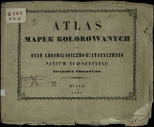
Title: Atlas mapek kolorowanych do rysu chronologiczno-historycznego państw nowożytnych Alexandra Zdanowicza
Publisher:
Place of publishing:
Description:
Scales differ ; 1 atlas (14 l. some folded) : lithogr., col. ; 26x31cm ; Cover title ; Designation on the maps: [leaf: 1, 8, 9, 10, 11] rytował A.C., [leaf 14] ryt. W. Drżewicki, [leaf 1, 8-11, 14] Lit. M. Przybylskiego ; Index on the cover: Niektóre Dzieła wydane nakładem i drukiem Księgarni pod firmą Józefa Zawadzkiego, w Wilnie
Detailed Resource Type:
Format:
File size 6,1 MB ; image/x.djvu
Resource Identifier:
Source:
CBGiOŚ. IGiPZ PAN, sygn. B.353 ; CBGiOŚ. IGiPZ PAN, sygn. B.8728 ; click here to follow the link
Language:
Rights:
Terms of use:
Digitizing institution:
Institute of Geography and Spatial Organization of the Polish Academy of Sciences
Original in:
Projects co-financed by:
Programme Innovative Economy, 2010-2014, Priority Axis 2. R&D infrastructure ; European Union. European Regional Development Fund
Access:
Object collections:
- Digital Repository of Scientific Institutes > Partners' collections > Institute of Geography and Spatial Organization PAS (IGiPZ PAN) > Library
- Digital Repository of Scientific Institutes > Partners' collections > Institute of Geography and Spatial Organization PAS (IGiPZ PAN) > Library > Maps and atlases
- Digital Repository of Scientific Institutes > Literature > Maps/Atlases
Last modified:
Oct 2, 2020
In our library since:
Oct 18, 2011
Number of object content downloads / hits:
254
All available object's versions:
https://rcin.org.pl./publication/8958
Show description in RDF format:
Show description in RDFa format:
Show description in OAI-PMH format:
| Edition name | Date |
|---|---|
| Atlas mapek kolorowanych do rysu chronologiczno-historycznego państw nowożytnych Aleksandra Zdanowicza, 1853 | Oct 2, 2020 |
Objects Similar
Samborska-Kukuć, Dorota Jaros, Maja Giebułtowski, Jerzy
Spruner, Karl von (1803–1892) Menke, Theodor (1819–1892) Justus Perthes (Gotha)
Rhode, C. E. Flemming, Carl (1806–1878)
Spruner, Karl von (1803–1892) Perthes, Johan Georg Justus (1749–1816) Menke, Theodor (1819–1892)
Schade, Theodor ( –1882) Flemming, Carl (1806–1878)
Droysen, Gustav (1838–1908) Andree, Richard (1835–1912) Geographische Anstalt von Velhagen und Klasing (Lipsk)
Nałęcz-Korzeniowska, Maria Regina (1793–1874) Lelewel, Joachim (1786–1861) Gałęzowski, Antoni ( –1830) Dayczer, Karol Szymon
Selves, Henri (17..-18..). Rys.


