- Search in all Repository
- Literature and maps
- Archeology
- Mills database
- Natural sciences
Advanced search
Advanced search
Advanced search
Advanced search
Advanced search

Object
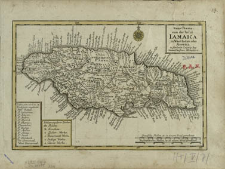
Title: Neue Charte von der Insul Iamaica in West-Indien oder America
Publisher:
zu finden bey Johann Christian Schreibern
Place of publishing:
Description:
Skala [ca 1:1 500 000] ; 1 mapa : miedzior., kolor. ; 17x26 cm ; Mapa pochodzi z: Atlas Selectus von allen Königreichen und Ländern der Welt, zum beqvemen Gebrauch in Schulen auf Reisen und bey dem Lesen der Zeitungen / vorfertiget und in Kupffer geschtochen von Johann George Schreibern. - Leipzig, [ca 1749] ; W ramce spis 14 parafii na Jamajce
Detailed Resource Type:
Format:
File size 2,8 MB ; image/x.djvu
Resource Identifier:
Source:
CBGiOŚ. IGiPZ PAN, call no. Ds.8477 ; click here to follow the link
Language:
Rights:
Terms of use:
Digitizing institution:
Institute of Geography and Spatial Organization of the Polish Academy of Sciences
Original in:
Projects co-financed by:
Programme Innovative Economy, 2010-2014, Priority Axis 2. R&D infrastructure ; European Union. European Regional Development Fund
Access:
Object collections:
- Digital Repository of Scientific Institutes > Partners' collections > Institute of Geography and Spatial Organization PAS (IGiPZ PAN) > Library
- Digital Repository of Scientific Institutes > Partners' collections > Institute of Geography and Spatial Organization PAS (IGiPZ PAN) > Library > Maps and atlases
- Digital Repository of Scientific Institutes > Literature > Maps/Atlases
Last modified:
Oct 2, 2020
In our library since:
Oct 30, 2015
Number of object content downloads / hits:
82
All available object's versions:
https://rcin.org.pl./publication/52894
Show description in RDF format:
Show description in RDFa format:
Show description in OAI-PMH format:
| Edition name | Date |
|---|---|
| Schreiber, Johann Christoph, [ca 1749], Neue Charte von der Insul Iamaica in West-Indien oder America | Oct 2, 2020 |
Objects Similar
Delisle, Guillaume (1675–1726) Buache, Philippe (1700–1773)
Sotzmann, Daniel Fridrich (1754–1840) Penningh, Harry John Glassbach, Carl Christian (1751-post 1791) Schmidt, Friedrich August Sander, Wilhelm (c. 1766 – 1836)
Güssefeld, Franz Ludwig (1744–1808)
Müller, Franz (1755–1816) Schütz, Carl (1745–1800)
Delisle, Guillaume (1675–1726) Condet, Johannes (1711–1781)

 INSTYTUT ARCHEOLOGII I ETNOLOGII POLSKIEJ AKADEMII NAUK
 INSTYTUT BADAŃ LITERACKICH POLSKIEJ AKADEMII NAUK
 INSTYTUT BADAWCZY LEŚNICTWA
 INSTYTUT BIOLOGII DOŚWIADCZALNEJ IM. MARCELEGO NENCKIEGO POLSKIEJ AKADEMII NAUK
 INSTYTUT BIOLOGII SSAKÓW POLSKIEJ AKADEMII NAUK
 INSTYTUT CHEMII FIZYCZNEJ PAN
 INSTYTUT CHEMII ORGANICZNEJ PAN
 INSTYTUT FILOZOFII I SOCJOLOGII PAN
 INSTYTUT GEOGRAFII I PRZESTRZENNEGO ZAGOSPODAROWANIA PAN
 INSTYTUT HISTORII im. TADEUSZA MANTEUFFLA POLSKIEJ AKADEMII NAUK
 INSTYTUT JĘZYKA POLSKIEGO POLSKIEJ AKADEMII NAUK
 INSTYTUT MATEMATYCZNY PAN
 INSTYTUT MEDYCYNY DOŚWIADCZALNEJ I KLINICZNEJ IM.MIROSŁAWA MOSSAKOWSKIEGO POLSKIEJ AKADEMII NAUK
 INSTYTUT PODSTAWOWYCH PROBLEMÓW TECHNIKI PAN
 INSTYTUT SLAWISTYKI PAN
 SIEĆ BADAWCZA ŁUKASIEWICZ - INSTYTUT TECHNOLOGII MATERIAŁÓW ELEKTRONICZNYCH
 MUZEUM I INSTYTUT ZOOLOGII POLSKIEJ AKADEMII NAUK
 INSTYTUT BADAŃ SYSTEMOWYCH PAN
 INSTYTUT BOTANIKI IM. WŁADYSŁAWA SZAFERA POLSKIEJ AKADEMII NAUK


