- O repozytorium
- Kolekcje
- Indeksy
- Historia przeglądania
-
Repozytoria RCIN
-
 INSTYTUT ARCHEOLOGII I ETNOLOGII POLSKIEJ AKADEMII NAUK
-
 INSTYTUT BADAŃ LITERACKICH POLSKIEJ AKADEMII NAUK
-
 INSTYTUT BADAWCZY LEŚNICTWA
-
 INSTYTUT BIOLOGII DOŚWIADCZALNEJ IM. MARCELEGO NENCKIEGO POLSKIEJ AKADEMII NAUK
-
 INSTYTUT BIOLOGII SSAKÓW POLSKIEJ AKADEMII NAUK
-
 INSTYTUT CHEMII FIZYCZNEJ PAN
-
 INSTYTUT CHEMII ORGANICZNEJ PAN
-
 INSTYTUT FILOZOFII I SOCJOLOGII PAN
-
 INSTYTUT GEOGRAFII I PRZESTRZENNEGO ZAGOSPODAROWANIA PAN
-
 INSTYTUT HISTORII im. TADEUSZA MANTEUFFLA POLSKIEJ AKADEMII NAUK
-
 INSTYTUT JĘZYKA POLSKIEGO POLSKIEJ AKADEMII NAUK
-
 INSTYTUT MATEMATYCZNY PAN
-
 INSTYTUT MEDYCYNY DOŚWIADCZALNEJ I KLINICZNEJ IM.MIROSŁAWA MOSSAKOWSKIEGO POLSKIEJ AKADEMII NAUK
-
 INSTYTUT PODSTAWOWYCH PROBLEMÓW TECHNIKI PAN
-
 INSTYTUT SLAWISTYKI PAN
-
 SIEĆ BADAWCZA ŁUKASIEWICZ - INSTYTUT TECHNOLOGII MATERIAŁÓW ELEKTRONICZNYCH
-
 MUZEUM I INSTYTUT ZOOLOGII POLSKIEJ AKADEMII NAUK
-
 INSTYTUT BADAŃ SYSTEMOWYCH PAN
-
 INSTYTUT BOTANIKI IM. WŁADYSŁAWA SZAFERA POLSKIEJ AKADEMII NAUK
-

Obiekt
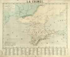
Tytuł: La Crimée
Wydawca:
Lith. Bouquillard. Edit. Rue St. Martin 294
Miejsce wydania:
Opis:
Scale [ca 1:1 250 000] ; 1 map : lithogr. col. ; 35x49 cm, on sheet 44x55 cm ; At the bottom of the map: Publication du Siècle. Journal quotidien ; Bar scales: Myriamétres ; Lieues Marines ; Milles Anglais ; Agatchs de Turquie ; Verstes de Russie ; There is a graticule on map for finding every index location ; Index: Nomenclature promt-trouveur des villes, pays, fleuves ; Dated according to the foundation date of Parisian journal Le Siècle (1836) and date of edition of alike Lith. Bouquillard maps from the Crimean War period (1854)
Szczegółowy typ zasobu:
Format:
Identyfikator zasobu:
Źródło:
CBGiOŚ. IGiPZ PAN, call no. PAN Ds.8301 [T.2A/30] ; kliknij tutaj, żeby przejść
Język:
Prawa:
Zasady wykorzystania:
Digitalizacja:
Institute of Geography and Spatial Organization of the Polish Academy of Sciences
Lokalizacja oryginału:
Dofinansowane ze środków:
Programme Innovative Economy, 2010-2014, Priority Axis 2. R&D infrastructure ; European Union. European Regional Development Fund
Dostęp:
Kolekcje, do których przypisany jest obiekt:
- Repozytorium Cyfrowe Instytutów Naukowych > Kolekcje Partnerów > Instytut Geografii i Przestrzennego Zagospodarowania PAN > Biblioteka Instytutu
- Repozytorium Cyfrowe Instytutów Naukowych > Kolekcje Partnerów > Instytut Geografii i Przestrzennego Zagospodarowania PAN > Biblioteka Instytutu > Mapy i atlasy
- Repozytorium Cyfrowe Instytutów Naukowych > Piśmiennictwo > Mapy/Atlasy
Data ostatniej modyfikacji:
2 paź 2020
Data dodania obiektu:
7 maj 2014
Liczba pobrań / odtworzeń:
111
Wszystkie dostępne wersje tego obiektu:
https://rcin.org.pl./publication/52109
Wyświetl opis w formacie RDF:
Wyświetl opis w formacie RDFa:
Wyświetl opis w formacie OAI-PMH:
| Nazwa wydania | Data |
|---|---|
| La Crimée, [ca 1836] | 2 paź 2020 |
Obiekty Podobne
Schnitzler, Jean Henri (1802–1871) Veuve Berger-Levrault et Fils. Wydawca


