- Search in all Repository
- Literature and maps
- Archeology
- Mills database
- Natural sciences
Advanced search
Advanced search
Advanced search
Advanced search
Advanced search

Object
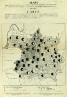
Title: Mapa obrazująca stosunek ilościowy ludności polskiej do rosyjskiej na obszarze ziem litewsko-białoruskich dawnej Rzeczypospolitej Polskiej = Carte représentante les quantités relatives de la population Polonaise et Russe sur les terrains de la Lithuanie et routhenie blache de l'ancienne République Polonaise.
Subtitle:
Publisher:
Place of publishing:
Description:
Skala [ca 1:2 000 000] ; 1 mapa ; 39x40 cm, na ark. 65x45 cm ; Dane statystyczne dotyczące ludności, zostały zaczerpnięte z rosyjskich źródeł urzędowych opartych na zasadzie spisu ludności w 1897 roku ; Data wyd. wg: Dokumentacja Geograficzna : Polskie mapy narodowościowe, wyznaniowe i językowe / A. Gawryszewski. - Warszawa, 1969 z. 4, poz. 46, s. 26 ; Tyt. i legenda równol. w jęz. pol. i fr.
Detailed Resource Type:
Format:
Resource Identifier:
Source:
CBGiOŚ. IGiPZ PAN, call no. PTG.661 [I-6A-11] ; click here to follow the link
Language:
Rights:
Terms of use:
Digitizing institution:
Institute of Geography and Spatial Organization of the Polish Academy of Sciences
Original in:
Projects co-financed by:
Programme Innovative Economy, 2010-2014, Priority Axis 2. R&D infrastructure ; European Union. European Regional Development Fund
Access:
Object collections:
- Digital Repository of Scientific Institutes > Partners' collections > Institute of Geography and Spatial Organization PAS (IGiPZ PAN) > Library
- Digital Repository of Scientific Institutes > Partners' collections > Institute of Geography and Spatial Organization PAS (IGiPZ PAN) > Library > Maps and atlases
- Digital Repository of Scientific Institutes > Partners' collections > Institute of Geography and Spatial Organization PAS (IGiPZ PAN) > Library > Selected collections > Polish Geographical Society Collection
- Digital Repository of Scientific Institutes > Literature > Maps/Atlases
Last modified:
Oct 2, 2020
In our library since:
Jan 30, 2014
Number of object content downloads / hits:
197
All available object's versions:
https://rcin.org.pl./publication/51418
Show description in RDF format:
Show description in RDFa format:
Show description in OAI-PMH format:
Objects Similar
Świechowski, Marian (1882–1934)
Szturm de Sztrem, Tadeusz (1892–1968)
Świechowski, Marian (1882–1934)
Świechowski, Marian (1882–1934)
Świechowski, Marian (1882–1934)
Świechowski, Marian (1882–1934)
Machlejd, Jerzy (1909–1940)

 INSTYTUT ARCHEOLOGII I ETNOLOGII POLSKIEJ AKADEMII NAUK
 INSTYTUT BADAŃ LITERACKICH POLSKIEJ AKADEMII NAUK
 INSTYTUT BADAWCZY LEŚNICTWA
 INSTYTUT BIOLOGII DOŚWIADCZALNEJ IM. MARCELEGO NENCKIEGO POLSKIEJ AKADEMII NAUK
 INSTYTUT BIOLOGII SSAKÓW POLSKIEJ AKADEMII NAUK
 INSTYTUT CHEMII FIZYCZNEJ PAN
 INSTYTUT CHEMII ORGANICZNEJ PAN
 INSTYTUT FILOZOFII I SOCJOLOGII PAN
 INSTYTUT GEOGRAFII I PRZESTRZENNEGO ZAGOSPODAROWANIA PAN
 INSTYTUT HISTORII im. TADEUSZA MANTEUFFLA POLSKIEJ AKADEMII NAUK
 INSTYTUT JĘZYKA POLSKIEGO POLSKIEJ AKADEMII NAUK
 INSTYTUT MATEMATYCZNY PAN
 INSTYTUT MEDYCYNY DOŚWIADCZALNEJ I KLINICZNEJ IM.MIROSŁAWA MOSSAKOWSKIEGO POLSKIEJ AKADEMII NAUK
 INSTYTUT PODSTAWOWYCH PROBLEMÓW TECHNIKI PAN
 INSTYTUT SLAWISTYKI PAN
 SIEĆ BADAWCZA ŁUKASIEWICZ - INSTYTUT TECHNOLOGII MATERIAŁÓW ELEKTRONICZNYCH
 MUZEUM I INSTYTUT ZOOLOGII POLSKIEJ AKADEMII NAUK
 INSTYTUT BADAŃ SYSTEMOWYCH PAN
 INSTYTUT BOTANIKI IM. WŁADYSŁAWA SZAFERA POLSKIEJ AKADEMII NAUK


