- About project
- Collections
- Indexes
- Recently viewed
-
RCIN Repositories
-
 INSTYTUT ARCHEOLOGII I ETNOLOGII POLSKIEJ AKADEMII NAUK
-
 INSTYTUT BADAŃ LITERACKICH POLSKIEJ AKADEMII NAUK
-
 INSTYTUT BADAWCZY LEŚNICTWA
-
 INSTYTUT BIOLOGII DOŚWIADCZALNEJ IM. MARCELEGO NENCKIEGO POLSKIEJ AKADEMII NAUK
-
 INSTYTUT BIOLOGII SSAKÓW POLSKIEJ AKADEMII NAUK
-
 INSTYTUT CHEMII FIZYCZNEJ PAN
-
 INSTYTUT CHEMII ORGANICZNEJ PAN
-
 INSTYTUT FILOZOFII I SOCJOLOGII PAN
-
 INSTYTUT GEOGRAFII I PRZESTRZENNEGO ZAGOSPODAROWANIA PAN
-
 INSTYTUT HISTORII im. TADEUSZA MANTEUFFLA POLSKIEJ AKADEMII NAUK
-
 INSTYTUT JĘZYKA POLSKIEGO POLSKIEJ AKADEMII NAUK
-
 INSTYTUT MATEMATYCZNY PAN
-
 INSTYTUT MEDYCYNY DOŚWIADCZALNEJ I KLINICZNEJ IM.MIROSŁAWA MOSSAKOWSKIEGO POLSKIEJ AKADEMII NAUK
-
 INSTYTUT PODSTAWOWYCH PROBLEMÓW TECHNIKI PAN
-
 INSTYTUT SLAWISTYKI PAN
-
 SIEĆ BADAWCZA ŁUKASIEWICZ - INSTYTUT TECHNOLOGII MATERIAŁÓW ELEKTRONICZNYCH
-
 MUZEUM I INSTYTUT ZOOLOGII POLSKIEJ AKADEMII NAUK
-
 INSTYTUT BADAŃ SYSTEMOWYCH PAN
-
 INSTYTUT BOTANIKI IM. WŁADYSŁAWA SZAFERA POLSKIEJ AKADEMII NAUK
-

Object
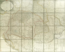
Title: Mappa Geographica novissima Regni Hungariæ divisi in suos Comitatus : nec non Regnorum Croatiæ Sclavoniæ Dalmatiæ Magni Principatus Transilvaniæ Partis Bosniæ Serviæ Bulgariæ et Walachiæ = Koenigreich Ungarn samt den angraenzenden Ländern
Subtitle:
Koenigreich Ungarn samt den angrænzenden Ländern ; Mappa Geographica novissima Regni Hungariae : nec non Regnorum Croatiae Sclavoniae Dalmatiae Magni Principatus Transilvaniae Partis Bosniae Serviae Bulgariae et Walachae
Contributor:
Wenzely, Anton von ; Mollo, Tranquillo (1767–1837) : Wyd.
Publisher:
Place of publishing:
Description:
Ex accuratoribus Tabulis congesta et corecta. ; Scale [ca 1:1 200 000] ; 1 map on 4 sheets : copperplate engraving, hand col. ; total 110x86 cm ; Prime meridian Ferro ; On the sheet : legend of the map, index of administrative division (Divisio Totius Regni in Ciculos et Comitatis) ; Title in Latin and German, legend of the map in German
Detailed Resource Type:
Format:
File size 15,2 MB ; application/pdf
Resource Identifier:
Source:
CBGiOŚ. IGiPZ PAN, call no. Ds.8189 [T.4/39] ; click here to follow the link
Language:
Rights:
Terms of use:
Digitizing institution:
Institute of Geography and Spatial Organization of the Polish Academy of Sciences
Original in:
Projects co-financed by:
Programme Innovative Economy, 2010-2014, Priority Axis 2. R&D infrastructure ; European Union. European Regional Development Fund
Access:
Object collections:
- Digital Repository of Scientific Institutes > Partners' collections > Institute of Geography and Spatial Organization PAS (IGiPZ PAN) > Library
- Digital Repository of Scientific Institutes > Partners' collections > Institute of Geography and Spatial Organization PAS (IGiPZ PAN) > Library > Maps and atlases
- Digital Repository of Scientific Institutes > Literature > Maps/Atlases
Last modified:
Oct 2, 2020
In our library since:
Oct 3, 2017
Number of object content downloads / hits:
174
All available object's versions:
https://rcin.org.pl./publication/51152
Show description in RDF format:
Show description in RDFa format:
Show description in OAI-PMH format:
Objects Similar
Lanszki, J. Körmendi, S. Hancz, C. Zalewski, A.
Lanszki, J. Körmendi, S.
Mátrai, K. Altbäcker, V. Hahn, I.
Kovács, András Donát Farkas, Jenő Zsolt Varjú, Viktor Szalai, Ádám Lennert, József Hoyk, Edit Csáki, Béla
Báldi, András
Kemenes, I. Nechay, G.
Matrai, K. Kabai, P.


