- O repozytorium
- Kolekcje
- Indeksy
- Historia przeglądania
-
Repozytoria RCIN
-
 INSTYTUT ARCHEOLOGII I ETNOLOGII POLSKIEJ AKADEMII NAUK
-
 INSTYTUT BADAŃ LITERACKICH POLSKIEJ AKADEMII NAUK
-
 INSTYTUT BADAWCZY LEŚNICTWA
-
 INSTYTUT BIOLOGII DOŚWIADCZALNEJ IM. MARCELEGO NENCKIEGO POLSKIEJ AKADEMII NAUK
-
 INSTYTUT BIOLOGII SSAKÓW POLSKIEJ AKADEMII NAUK
-
 INSTYTUT CHEMII FIZYCZNEJ PAN
-
 INSTYTUT CHEMII ORGANICZNEJ PAN
-
 INSTYTUT FILOZOFII I SOCJOLOGII PAN
-
 INSTYTUT GEOGRAFII I PRZESTRZENNEGO ZAGOSPODAROWANIA PAN
-
 INSTYTUT HISTORII im. TADEUSZA MANTEUFFLA POLSKIEJ AKADEMII NAUK
-
 INSTYTUT JĘZYKA POLSKIEGO POLSKIEJ AKADEMII NAUK
-
 INSTYTUT MATEMATYCZNY PAN
-
 INSTYTUT MEDYCYNY DOŚWIADCZALNEJ I KLINICZNEJ IM.MIROSŁAWA MOSSAKOWSKIEGO POLSKIEJ AKADEMII NAUK
-
 INSTYTUT PODSTAWOWYCH PROBLEMÓW TECHNIKI PAN
-
 INSTYTUT SLAWISTYKI PAN
-
 SIEĆ BADAWCZA ŁUKASIEWICZ - INSTYTUT TECHNOLOGII MATERIAŁÓW ELEKTRONICZNYCH
-
 MUZEUM I INSTYTUT ZOOLOGII POLSKIEJ AKADEMII NAUK
-
 INSTYTUT BADAŃ SYSTEMOWYCH PAN
-
 INSTYTUT BOTANIKI IM. WŁADYSŁAWA SZAFERA POLSKIEJ AKADEMII NAUK
-
- Wyszukaj w całym Repozytorium
- Piśmiennictwo i mapy
- Archeologia
- Baza Młynów
- Nauki przyrodnicze
Wyszukiwanie zaawansowane
Wyszukiwanie zaawansowane
Wyszukiwanie zaawansowane
Wyszukiwanie zaawansowane
Wyszukiwanie zaawansowane

Obiekt
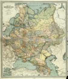
Tytuł: Karta Evropejskoj Rossìi
Wydawca:
[s.n.] ; (Kartogr. zav. A. Il'ina)
Miejsce wydania:
[S. l.] ; (S.P.B. [S. Peterburg])
Opis:
1 mapa : kolor. ; 51x44 cm ; Skala 1:7 350 000, 175 verst'' v'' Angl. dûjmě ; Współrz. geogr. od południków: Pułkowo, Ferro, Greenwich i Paryż ; Data wyd. [ca 1908-1913] na podst. przebiegu linii kolejowych istniejących i projektowanych
Szczegółowy typ zasobu:
Format:
Identyfikator zasobu:
Źródło:
CBGiOŚ. IGiPZ PAN, sygn. PAN D.2333 [T.2A/10] ; kliknij tutaj, żeby przejść
Język:
Prawa:
Zasady wykorzystania:
Digitalizacja:
Instytut Geografii i Przestrzennego Zagospodarowania Polskiej Akademii Nauk
Lokalizacja oryginału:
Dofinansowane ze środków:
Program Operacyjny Innowacyjna Gospodarka, lata 2010-2014, Priorytet 2. Infrastruktura strefy B + R ; Unia Europejska. Europejski Fundusz Rozwoju Regionalnego
Dostęp:
Kolekcje, do których przypisany jest obiekt:
- Repozytorium Cyfrowe Instytutów Naukowych > Kolekcje Partnerów > Instytut Geografii i Przestrzennego Zagospodarowania PAN > Biblioteka Instytutu
- Repozytorium Cyfrowe Instytutów Naukowych > Kolekcje Partnerów > Instytut Geografii i Przestrzennego Zagospodarowania PAN > Biblioteka Instytutu > Mapy i atlasy
- Repozytorium Cyfrowe Instytutów Naukowych > Piśmiennictwo > Mapy/Atlasy
Data ostatniej modyfikacji:
2 paź 2020
Data dodania obiektu:
24 sty 2014
Liczba pobrań / odtworzeń:
102
Wszystkie dostępne wersje tego obiektu:
https://rcin.org.pl./publication/50370
Wyświetl opis w formacie RDF:
Wyświetl opis w formacie RDFa:
Wyświetl opis w formacie OAI-PMH:
| Nazwa wydania | Data |
|---|---|
| Ili'n, Aleksej Alekseevič (1857-1942), [ante 1913], Karta Evropejskoj Rossìi | 2 paź 2020 |
Obiekty Podobne
Ili'n, Aleksej Aleksejevič (1857–1942)
Rosja. Armiâ. Glavnyj štab. Voenno-topografičeskij otdel. Instytucja sprawcza
Rosja. Armiâ. Glavnyj štab. Voenno-topografičeskij otdel. Instytucja sprawcza
Rosja. Armiâ. Glavnyj štab. Litografìâ kartografičeskago zavedenìâ. Wydawca Rosja. Armiâ. Glavnyj štab. Voenno-topografičeskij otdel. Instytucja sprawcza
Rosja. Armiâ. Glavnyj štab. Litografìâ kartografičeskago zavedenìâ. Wydawca Rosja. Armiâ. Glavnyj štab. Voenno-topografičeskij otdel. Instytucja sprawcza
Rosja. Armiâ. Glavnyj štab. Litografìâ kartografičeskago zavedenìâ. Wydawca Rosja. Armiâ. Glavnyj štab. Voenno-topografičeskij otdel. Instytucja sprawcza


