- Wyszukaj w całym Repozytorium
- Piśmiennictwo i mapy
- Archeologia
- Baza Młynów
- Nauki przyrodnicze
Wyszukiwanie zaawansowane
Wyszukiwanie zaawansowane
Wyszukiwanie zaawansowane
Wyszukiwanie zaawansowane
Wyszukiwanie zaawansowane

Obiekt
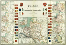
Tytuł: Polska : w 10 ważniejszych okresach historycznych z herbami województw i ziem do niej należących
Współtwórca:
Krajowy Dom Wydawniczy Fr. Karpowicz
Wydawca:
Jan Fr. Karpowicz ; (Lit. W. Główczewski)
Miejsce wydania:
Opis:
[Skala ca 1:4 800 000] ; 1 mapa : kolor. ; 56x83 cm, na ark. 62x92 cm ; Mapy poboczne: "Polska za Mieczysława I go", "Polska za Bolesława Chrobrego 992-1025 r.", "Polska za Bolesława Krzywoustego 1111-1138 r.", "Polska za Kazimierza Wielkiego 1333-1370 r.", "Polska w ostatnim dziesięcioleciu XV w.", "Polska za Stefana Batorego 1576-1586 r.", "Polska po rozejmie Andruszowskim i traktacie Buczackim 1673 r.", "Polska podczas trzech rozbiorów", "Księstwo Warszawskie utworzone przez Napolewona I r. 1807, powiększone r. 1809" ; Po obu stronach mapy herby Korony i Litwy oraz herby królów elekcyjnych. Przy mapie tabela z podziałem terytorialnym Polski w 1770 r ; Data wyd. wg Bibliteki Cyfrowej Uniwersytetu Wrocławskiego, http://www.bibliotekacyfrowa.pl/publication/32661
Szczegółowy typ zasobu:
Format:
Identyfikator zasobu:
Źródło:
CBGiOŚ. IGiPZ PAN, sygn. D.12055 [m. ogólnogeogr.56] ; kliknij tutaj, żeby przejść
Język:
Prawa:
Zasady wykorzystania:
Digitalizacja:
Instytut Geografii i Przestrzennego Zagospodarowania Polskiej Akademii Nauk
Lokalizacja oryginału:
Dofinansowane ze środków:
Program Operacyjny Innowacyjna Gospodarka, lata 2010-2014, Priorytet 2. Infrastruktura strefy B + R ; Unia Europejska. Europejski Fundusz Rozwoju Regionalnego
Dostęp:
Kolekcje, do których przypisany jest obiekt:
- Repozytorium Cyfrowe Instytutów Naukowych > Kolekcje Partnerów > Instytut Geografii i Przestrzennego Zagospodarowania PAN > Biblioteka Instytutu
- Repozytorium Cyfrowe Instytutów Naukowych > Kolekcje Partnerów > Instytut Geografii i Przestrzennego Zagospodarowania PAN > Biblioteka Instytutu > Mapy i atlasy
- Repozytorium Cyfrowe Instytutów Naukowych > Piśmiennictwo > Mapy/Atlasy
Data ostatniej modyfikacji:
23 sie 2021
Data dodania obiektu:
11 cze 2013
Liczba pobrań / odtworzeń:
291
Wszystkie dostępne wersje tego obiektu:
https://rcin.org.pl./publication/41900
Wyświetl opis w formacie RDF:
Wyświetl opis w formacie RDFa:
Wyświetl opis w formacie OAI-PMH:
| Nazwa wydania | Data |
|---|---|
| Polska : w 10 ważniejszych okresach historycznych z herbami województw i ziem do niej należących, [ca 1930] | 23 sie 2021 |
Obiekty Podobne
Bończa-Tomaszewski, Stanisław (1861–1935)
Semkowicz, Władysław Aleksander (1878–1949)
Gostyński, Władysław Bazewicz, Józef Michał (c. 1862 – 1928) Litografia Artystyczna W. Główczewski (Warszawa)
Semkowicz, Władysław Aleksander (1878–1949)

 INSTYTUT ARCHEOLOGII I ETNOLOGII POLSKIEJ AKADEMII NAUK
 INSTYTUT BADAŃ LITERACKICH POLSKIEJ AKADEMII NAUK
 INSTYTUT BADAWCZY LEŚNICTWA
 INSTYTUT BIOLOGII DOŚWIADCZALNEJ IM. MARCELEGO NENCKIEGO POLSKIEJ AKADEMII NAUK
 INSTYTUT BIOLOGII SSAKÓW POLSKIEJ AKADEMII NAUK
 INSTYTUT CHEMII FIZYCZNEJ PAN
 INSTYTUT CHEMII ORGANICZNEJ PAN
 INSTYTUT FILOZOFII I SOCJOLOGII PAN
 INSTYTUT GEOGRAFII I PRZESTRZENNEGO ZAGOSPODAROWANIA PAN
 INSTYTUT HISTORII im. TADEUSZA MANTEUFFLA POLSKIEJ AKADEMII NAUK
 INSTYTUT JĘZYKA POLSKIEGO POLSKIEJ AKADEMII NAUK
 INSTYTUT MATEMATYCZNY PAN
 INSTYTUT MEDYCYNY DOŚWIADCZALNEJ I KLINICZNEJ IM.MIROSŁAWA MOSSAKOWSKIEGO POLSKIEJ AKADEMII NAUK
 INSTYTUT PODSTAWOWYCH PROBLEMÓW TECHNIKI PAN
 INSTYTUT SLAWISTYKI PAN
 SIEĆ BADAWCZA ŁUKASIEWICZ - INSTYTUT TECHNOLOGII MATERIAŁÓW ELEKTRONICZNYCH
 MUZEUM I INSTYTUT ZOOLOGII POLSKIEJ AKADEMII NAUK
 INSTYTUT BADAŃ SYSTEMOWYCH PAN
 INSTYTUT BOTANIKI IM. WŁADYSŁAWA SZAFERA POLSKIEJ AKADEMII NAUK


