- Search in all Repository
- Literature and maps
- Archeology
- Mills database
- Natural sciences
Advanced search
Advanced search
Advanced search
Advanced search
Advanced search

Object
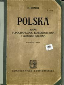
Title: Polska mapa topograficzna, komunikacyjna i administracyjna podziałka 1:600.000
Contributor:
Instytut Kartograficzny im. Eugeniusza Romera ; Książnica-Atlas, Zjednoczone Zakłady Kartograficzne i Wydawnicze Towarzystwa Nauczycieli Szkół Średnich i Wyższych
Publisher:
nakład i druk Ska Akc. Książnica -Atlas Zjednoczone Zakłady kartograficzne i wydawnicze T.N.S.W.
Place of publishing:
Description:
Scale 1:600 000 ; 1 map : col. ; 163x145 cm, folded in cover 41x30 cm ; Ancillary maps: Małe Morze - podziałka 1:250 000, Wojsko - podziałka 1:5,500.000, Kościół Rzym.-Kat. - podziałka 1:13,000.000, Szkolnictwo - podziałka 1:13,000.000, Sadownictwo - podziałka 1:13,000.000, P.K.P. poczta - podziałka 1:13,000.000; mapy w skali 1:100 000: Kraków, Łódź, Bydgoszcz, Wilno, Okręg Węglowy, Lublin, Poznań, Częstochowa, Lwów oraz Warszawa - podziałka 1:30.000
Detailed Resource Type:
Format:
Resource Identifier:
Source:
CBGiOŚ. IGiPZ PAN, call no. D.3298 [m.polit.-adm.31] ; CBGiOŚ. IGiPZ PAN, call no. D.6050 [m.polit.-adm.79] ; click here to follow the link
Language:
Rights:
Terms of use:
Digitizing institution:
Institute of Geography and Spatial Organization of the Polish Academy of Sciences
Original in:
Projects co-financed by:
Programme Innovative Economy, 2010-2014, Priority Axis 2. R&D infrastructure ; European Union. European Regional Development Fund
Access:
Object collections:
- Digital Repository of Scientific Institutes > Partners' collections > Institute of Geography and Spatial Organization PAS (IGiPZ PAN) > Library
- Digital Repository of Scientific Institutes > Partners' collections > Institute of Geography and Spatial Organization PAS (IGiPZ PAN) > Library > Books
- Digital Repository of Scientific Institutes > Partners' collections > Institute of Geography and Spatial Organization PAS (IGiPZ PAN) > Library > Maps and atlases
- Digital Repository of Scientific Institutes > Partners' collections > Institute of Geography and Spatial Organization PAS (IGiPZ PAN) > Library > Selected collections > Polish Geographical Society Collection
- Digital Repository of Scientific Institutes > Literature > Maps/Atlases
Last modified:
Jan 2, 2025
In our library since:
May 7, 2014
Number of object content downloads / hits:
363
All available object's versions:
https://rcin.org.pl./publication/41459
Show description in RDF format:
Show description in RDFa format:
Show description in OAI-PMH format:
| Edition name | Date |
|---|---|
| Romer, Eugeniusz (1871-1954), 1929, Polska mapa topograficzna, komunikacyjna i administracyjna podziałka 1:600.000 | Jan 2, 2025 |
Objects Similar
Romer, Eugeniusz (1871–1954)
Romer, Eugeniusz (1871–1954) Wąsowicz, Józef (1900–1964) Instytut Kartograficzny im. Eugeniusza Romera
Romer, Eugeniusz (1871–1954) Wąsowicz, Józef (1900–1964) Instytut Kartograficzny im. Eugeniusza Romera Zjednoczone Zakłady Kartograficzne i Wydawnicze Towarzystwa Nauczycieli Szkół Wyższych Książnica-Atlas (Wrocław)
Romer, Eugeniusz (1871–1954) Wąsowicz, Józef (1900–1964) Instytut Kartograficzny im. Eugeniusza Romera Zjednoczone Zakłady Kartograficzne i Wydawnicze Towarzystwa Nauczycieli Szkół Wyższych Książnica-Atlas (Wrocław)

 INSTYTUT ARCHEOLOGII I ETNOLOGII POLSKIEJ AKADEMII NAUK
 INSTYTUT BADAŃ LITERACKICH POLSKIEJ AKADEMII NAUK
 INSTYTUT BADAWCZY LEŚNICTWA
 INSTYTUT BIOLOGII DOŚWIADCZALNEJ IM. MARCELEGO NENCKIEGO POLSKIEJ AKADEMII NAUK
 INSTYTUT BIOLOGII SSAKÓW POLSKIEJ AKADEMII NAUK
 INSTYTUT CHEMII FIZYCZNEJ PAN
 INSTYTUT CHEMII ORGANICZNEJ PAN
 INSTYTUT FILOZOFII I SOCJOLOGII PAN
 INSTYTUT GEOGRAFII I PRZESTRZENNEGO ZAGOSPODAROWANIA PAN
 INSTYTUT HISTORII im. TADEUSZA MANTEUFFLA POLSKIEJ AKADEMII NAUK
 INSTYTUT JĘZYKA POLSKIEGO POLSKIEJ AKADEMII NAUK
 INSTYTUT MATEMATYCZNY PAN
 INSTYTUT MEDYCYNY DOŚWIADCZALNEJ I KLINICZNEJ IM.MIROSŁAWA MOSSAKOWSKIEGO POLSKIEJ AKADEMII NAUK
 INSTYTUT PODSTAWOWYCH PROBLEMÓW TECHNIKI PAN
 INSTYTUT SLAWISTYKI PAN
 SIEĆ BADAWCZA ŁUKASIEWICZ - INSTYTUT TECHNOLOGII MATERIAŁÓW ELEKTRONICZNYCH
 MUZEUM I INSTYTUT ZOOLOGII POLSKIEJ AKADEMII NAUK
 INSTYTUT BADAŃ SYSTEMOWYCH PAN
 INSTYTUT BOTANIKI IM. WŁADYSŁAWA SZAFERA POLSKIEJ AKADEMII NAUK


