- Search in all Repository
- Literature and maps
- Archeology
- Mills database
- Natural sciences
Advanced search
Advanced search
Advanced search
Advanced search
Advanced search

Object
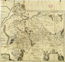
Title: Karta predstavlâûŝaâ Malorusiû pod vladeniem Pol'skim
Creator:
Beauplan, Guillaume Le Vasseur de (c. 1600 – 1675) ; Bantyš-Kamenskij, Dmitrij Nikolaevič (1788–1850) : Tł.
Date issued/created:
Resource type:
Publisher:
Place of publishing:
Description:
Skala [ca 1:1 800 000] ; 1 mapa : miedzior. ; 49x52 cm ; Na mapie zapis: sostavlennaâ v načale XVII veka inženierom Boplanom ; na rossijskij âzyk peredoložennaâ Dmitriem Bantyš-Kamenskim ; Rosyjska wersja językowa mapy "Carte d'Ukrainie [...]" Guillaume Le Vasseur de Beauplan'a z 1660 r. ; Południk zerowy Ferro ; Orientacja południowa
Detailed Resource Type:
Format:
Rozmiar pliku 2,8 MB ; image/x.djvu
Resource Identifier:
Source:
CBGiOŚ. IGiPZ PAN, sygn. D.1905 [I.7E-6] ; click here to follow the link
Language:
Rights:
Terms of use:
Digitizing institution:
Instytut Geografii i Przestrzennego Zagospodarowania Polskiej Akademii Nauk
Original in:
Projects co-financed by:
Program Operacyjny Innowacyjna Gospodarka, lata 2010-2014, Priorytet 2. Infrastruktura strefy B + R ; Unia Europejska. Europejski Fundusz Rozwoju Regionalnego
Access:
Object collections:
- Digital Repository of Scientific Institutes > Partners' collections > Institute of Geography and Spatial Organization PAS (IGiPZ PAN) > Library
- Digital Repository of Scientific Institutes > Partners' collections > Institute of Geography and Spatial Organization PAS (IGiPZ PAN) > Library > Maps and atlases
- Digital Repository of Scientific Institutes > Literature > Maps/Atlases
Last modified:
Oct 2, 2020
In our library since:
Aug 22, 2011
Number of object content downloads / hits:
500
All available object's versions:
https://rcin.org.pl./publication/3106
Show description in RDF format:
Show description in RDFa format:
Show description in OAI-PMH format:
| Edition name | Date |
|---|---|
| Beauplan, Guillaume Le Vasseur de (ca 1600-1675), 1829, Karta predstavlâûŝaâ Malorusiû pod vladeniem Pol'skim | Oct 2, 2020 |
Objects Similar
Wanner, Catherine King-Savic, Sandra Tosic, Jelena Tarkhanova, Oleksandra
Butko, Matej
Trzeszczyńska, Patrycja
Ivanov, Mykyta
Polit, Beata
Ries, Nancy
Susulovsky, Andrij Winiszewska-Ślipińska, Grażyna

 INSTYTUT ARCHEOLOGII I ETNOLOGII POLSKIEJ AKADEMII NAUK
 INSTYTUT BADAŃ LITERACKICH POLSKIEJ AKADEMII NAUK
 INSTYTUT BADAWCZY LEŚNICTWA
 INSTYTUT BIOLOGII DOŚWIADCZALNEJ IM. MARCELEGO NENCKIEGO POLSKIEJ AKADEMII NAUK
 INSTYTUT BIOLOGII SSAKÓW POLSKIEJ AKADEMII NAUK
 INSTYTUT CHEMII FIZYCZNEJ PAN
 INSTYTUT CHEMII ORGANICZNEJ PAN
 INSTYTUT FILOZOFII I SOCJOLOGII PAN
 INSTYTUT GEOGRAFII I PRZESTRZENNEGO ZAGOSPODAROWANIA PAN
 INSTYTUT HISTORII im. TADEUSZA MANTEUFFLA POLSKIEJ AKADEMII NAUK
 INSTYTUT JĘZYKA POLSKIEGO POLSKIEJ AKADEMII NAUK
 INSTYTUT MATEMATYCZNY PAN
 INSTYTUT MEDYCYNY DOŚWIADCZALNEJ I KLINICZNEJ IM.MIROSŁAWA MOSSAKOWSKIEGO POLSKIEJ AKADEMII NAUK
 INSTYTUT PODSTAWOWYCH PROBLEMÓW TECHNIKI PAN
 INSTYTUT SLAWISTYKI PAN
 SIEĆ BADAWCZA ŁUKASIEWICZ - INSTYTUT TECHNOLOGII MATERIAŁÓW ELEKTRONICZNYCH
 MUZEUM I INSTYTUT ZOOLOGII POLSKIEJ AKADEMII NAUK
 INSTYTUT BADAŃ SYSTEMOWYCH PAN
 INSTYTUT BOTANIKI IM. WŁADYSŁAWA SZAFERA POLSKIEJ AKADEMII NAUK


