- O repozytorium
- Kolekcje
- Indeksy
- Historia przeglądania
-
Repozytoria RCIN
-
 INSTYTUT ARCHEOLOGII I ETNOLOGII POLSKIEJ AKADEMII NAUK
-
 INSTYTUT BADAŃ LITERACKICH POLSKIEJ AKADEMII NAUK
-
 INSTYTUT BADAWCZY LEŚNICTWA
-
 INSTYTUT BIOLOGII DOŚWIADCZALNEJ IM. MARCELEGO NENCKIEGO POLSKIEJ AKADEMII NAUK
-
 INSTYTUT BIOLOGII SSAKÓW POLSKIEJ AKADEMII NAUK
-
 INSTYTUT CHEMII FIZYCZNEJ PAN
-
 INSTYTUT CHEMII ORGANICZNEJ PAN
-
 INSTYTUT FILOZOFII I SOCJOLOGII PAN
-
 INSTYTUT GEOGRAFII I PRZESTRZENNEGO ZAGOSPODAROWANIA PAN
-
 INSTYTUT HISTORII im. TADEUSZA MANTEUFFLA POLSKIEJ AKADEMII NAUK
-
 INSTYTUT JĘZYKA POLSKIEGO POLSKIEJ AKADEMII NAUK
-
 INSTYTUT MATEMATYCZNY PAN
-
 INSTYTUT MEDYCYNY DOŚWIADCZALNEJ I KLINICZNEJ IM.MIROSŁAWA MOSSAKOWSKIEGO POLSKIEJ AKADEMII NAUK
-
 INSTYTUT PODSTAWOWYCH PROBLEMÓW TECHNIKI PAN
-
 INSTYTUT SLAWISTYKI PAN
-
 SIEĆ BADAWCZA ŁUKASIEWICZ - INSTYTUT TECHNOLOGII MATERIAŁÓW ELEKTRONICZNYCH
-
 MUZEUM I INSTYTUT ZOOLOGII POLSKIEJ AKADEMII NAUK
-
 INSTYTUT BADAŃ SYSTEMOWYCH PAN
-
 INSTYTUT BOTANIKI IM. WŁADYSŁAWA SZAFERA POLSKIEJ AKADEMII NAUK
-
- Wyszukaj w całym Repozytorium
- Piśmiennictwo i mapy
- Archeologia
- Baza Młynów
- Nauki przyrodnicze
Wyszukiwanie zaawansowane
Wyszukiwanie zaawansowane
Wyszukiwanie zaawansowane
Wyszukiwanie zaawansowane
Wyszukiwanie zaawansowane

Obiekt
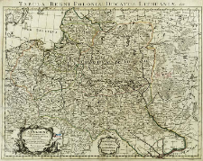
Tytuł: La Pologne : dressée sur ce qu'en ont donné Starovolsk, Beuplan, Hartnoch, et autres Auteurs : Rectifiee par les Observations d'Hevelius etc.
Twórca:
Delisle, Guillaume (1675–1726) ; Condet, Johannes (1711–1781) : Ryt.
Data wydania/powstania:
Typ zasobu:
Inny tytuł:
Tabula Regni Poloniae Ducatus Lithuaniae &c
Wydawca:
Miejsce wydania:
Opis:
Scale [ca 1:2 600 000] ; 1 map : copperplate engraving, hand col. ; 48x62 cm, on sheet 54x69 cm ; Prime meridian [Ferro] ; Map from: Atlas nouveau contenant toutes les parties du monde [...]. - Amsterdam, 1730, vol. 3
Szczegółowy typ zasobu:
Format:
File size 3,4 MB ; image/x.djvu
Identyfikator zasobu:
Źródło:
CBGiOŚ. IGiPZ PAN, call no. Ds.8098 [I.1B-9] ; kliknij tutaj, żeby przejść
Język:
Prawa:
Zasady wykorzystania:
Digitalizacja:
Institute of Geography and Spatial Organization of the Polish Academy of Sciences
Lokalizacja oryginału:
Dofinansowane ze środków:
Programme Innovative Economy, 2010-2014, Priority Axis 2. R&D infrastructure ; European Union. European Regional Development Fund
Dostęp:
Kolekcje, do których przypisany jest obiekt:
- Repozytorium Cyfrowe Instytutów Naukowych > Kolekcje Partnerów > Instytut Geografii i Przestrzennego Zagospodarowania PAN > Biblioteka Instytutu
- Repozytorium Cyfrowe Instytutów Naukowych > Kolekcje Partnerów > Instytut Geografii i Przestrzennego Zagospodarowania PAN > Biblioteka Instytutu > Mapy i atlasy
- Repozytorium Cyfrowe Instytutów Naukowych > Piśmiennictwo > Mapy/Atlasy
Data ostatniej modyfikacji:
2 paź 2020
Data dodania obiektu:
6 wrz 2011
Liczba pobrań / odtworzeń:
273
Wszystkie dostępne wersje tego obiektu:
https://rcin.org.pl./publication/2870
Wyświetl opis w formacie RDF:
Wyświetl opis w formacie RDFa:
Wyświetl opis w formacie OAI-PMH:
Obiekty Podobne
Delisle, Guillaume (1675–1726)
Delisle, Guillaume (1675–1726) Buache, Philippe (1700–1773)
Delisle, Guillaume (1675–1726) Buache, Philippe (1700–1773)
Delisle, Guillaume (1675–1726)
Delisle, Guillaume (1675–1726)


