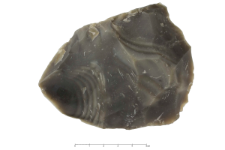
Object
Falster Flint : 2D documentation
Resource type:
Name:
Falster Flint : 2D documentation
Other names:
Type of object:
Location- administrative unit (present):
Topographic location:
See the map:
Hydrographic network:
beach Dänish-Nienhof (Baltic Sea coast)
Object type:
Characteristics of the object- technique:
Characteristics of the object- raw material:
Upper Cretaceous (Maastrichtiant)
Characteristics of the object- colour:
Characteristics of the object- transparency:
Characteristics of the object- fracture:
Characteristics of the object- texture/facture:
longitudial banding, bands in different thikness in different gray colour shades
Characteristics of the object- luster:
Characteristics of the object- cortex:
Characteristics of the object- transition:
Characteristics of the object- patina:
Characteristics of the object- colour of patine:
Characteristics of the object- width:
Characteristics of the object- thickness:
Characteristics of the object- length:
Characteristics of the object- weight:
Object description:
secondary, moraine from Weichselian glaciation; coordinates; " 54°28`60" N 10°06`07" E
Research Manager/ Creator of Collection:
Accession number:
Chronology:
Relation:
Detailed Resource Type:
Resource Identifier:
Rights:
Creative Commons Attribution BY-SA 3.0 PL license
Terms of use:
Copyright-protected material. [CC BY-SA 3.0 PL] May be used within the scope specified in Creative Commons Attribution BY-SA 3.0 PL license, full text available at: ; -
Digitizing institution:
Institute of Archaeology and Ethnology of the Polish Academy of Sciences
Original in:
Institute of Archaeology and Ethnology of the Polish Academy of Sciences
Projects co-financed by:
Operational Program Digital Poland, 2014-2020, Measure 2.3: Digital accessibility and usefulness of public sector information; funds from the European Regional Development Fund and national co-financing from the state budget. ; European Union. European Regional Development Fund
Access:
Object collections:
- Digital Repository of Scientific Institutes > Partners' collections > Institute of Archeology and Ethnology PAS > Rock Atlas
- Digital Repository of Scientific Institutes > Partners' collections > Institute of Archeology and Ethnology PAS > Rock Atlas > Siliceous Rocks > Flints
- Digital Repository of Scientific Institutes > Scientific data and objects > Humanities and Social Sciences > Archaeological collections
Last modified:
Jul 11, 2022
In our library since:
Mar 29, 2021
Number of object content downloads / hits:
17
All available object's versions:
https://rcin.org.pl./publication/151664
Show description in RDF format:
Show description in RDFa format:
Show description in OAI-PMH format:
| Edition name | Date |
|---|---|
| Falster Flint : dokumentacja [2D] | Jul 11, 2022 |

 INSTYTUT ARCHEOLOGII I ETNOLOGII POLSKIEJ AKADEMII NAUK
 INSTYTUT BADAŃ LITERACKICH POLSKIEJ AKADEMII NAUK
 INSTYTUT BADAWCZY LEŚNICTWA
 INSTYTUT BIOLOGII DOŚWIADCZALNEJ IM. MARCELEGO NENCKIEGO POLSKIEJ AKADEMII NAUK
 INSTYTUT BIOLOGII SSAKÓW POLSKIEJ AKADEMII NAUK
 INSTYTUT CHEMII FIZYCZNEJ PAN
 INSTYTUT CHEMII ORGANICZNEJ PAN
 INSTYTUT FILOZOFII I SOCJOLOGII PAN
 INSTYTUT GEOGRAFII I PRZESTRZENNEGO ZAGOSPODAROWANIA PAN
 INSTYTUT HISTORII im. TADEUSZA MANTEUFFLA POLSKIEJ AKADEMII NAUK
 INSTYTUT JĘZYKA POLSKIEGO POLSKIEJ AKADEMII NAUK
 INSTYTUT MATEMATYCZNY PAN
 INSTYTUT MEDYCYNY DOŚWIADCZALNEJ I KLINICZNEJ IM.MIROSŁAWA MOSSAKOWSKIEGO POLSKIEJ AKADEMII NAUK
 INSTYTUT PODSTAWOWYCH PROBLEMÓW TECHNIKI PAN
 INSTYTUT SLAWISTYKI PAN
 SIEĆ BADAWCZA ŁUKASIEWICZ - INSTYTUT TECHNOLOGII MATERIAŁÓW ELEKTRONICZNYCH
 MUZEUM I INSTYTUT ZOOLOGII POLSKIEJ AKADEMII NAUK
 INSTYTUT BADAŃ SYSTEMOWYCH PAN
 INSTYTUT BOTANIKI IM. WŁADYSŁAWA SZAFERA POLSKIEJ AKADEMII NAUK


