Obiekt
Dostępne formaty:
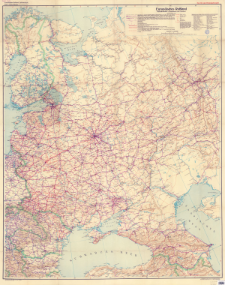
Pobierz wszystkieTytuł: Europäisches Rußland : Verkehrskarte (Eisenbahnen und Straßen)
Twórca:
Berliner Lithographisches Institut. Drukarz ; Niemcy. Heer. Generalstab. Abteilung für Kriegskarten und Vermessungswesen. Wydawca
Data wydania/powstania:
Typ zasobu:
Inny tytuł:
Europäisches Rußland : Verkehrskarte
Wydawca:
Generalstab des Heeres, Abt. f. Kr. K. u. Verm. W. (IV. Mil Geo) ; (Litographie und Druck: Berliner Litographisches Institut)
Miejsce wydania:
Opis:
Scale 1:2 500 000 ; 1 map : color ; 131x105 cm, on sheet 137x111 cm ; In the corner of the map: 9.41. D 23 ; Anlage zu: Mil-Geo-Angaben über das Eurpäische Rußland. Mappe A: Allgemeiner Überblick ; Date of issue based on BNF online
Szczegółowy typ zasobu:
Format:
Identyfikator zasobu:
Źródło:
CBGiOŚ. IGiPZ PAN, call no. D.11403 ; kliknij tutaj, żeby przejść
Język:
Zakres:
Prawa:
Zasady wykorzystania:
Digitalizacja:
Institute of Geography and Spatial Organization of the Polish Academy of Sciences
Lokalizacja oryginału:
Dofinansowane ze środków:
Dostęp:
Kolekcje, do których przypisany jest obiekt:
- Repozytorium Cyfrowe Instytutów Naukowych > Kolekcje Partnerów > Instytut Geografii i Przestrzennego Zagospodarowania PAN > Biblioteka Instytutu > Mapy i atlasy
- Repozytorium Cyfrowe Instytutów Naukowych > Piśmiennictwo > Mapy/Atlasy
Data ostatniej modyfikacji:
2 paź 2020
Data dodania obiektu:
18 gru 2019
Liczba pobrań / odtworzeń:
136
Wszystkie dostępne wersje tego obiektu:
https://rcin.org.pl./publication/94268
Wyświetl opis w formacie RDF:
Wyświetl opis w formacie RDFa:
Wyświetl opis w formacie OAI-PMH:
| Nazwa wydania | Data |
|---|---|
| Europäisches Rußland : Verkehrskarte (Eisenbahnen und Straßen), [1941] | 2 paź 2020 |
Obiekty Podobne
Niemcy. Heer. Generalstab. Abteilung für Kriegskarten und Vermessungswesen. Wydawca
Justus Perthes (Gotha). Instytucja sprawcza Wydawca
Ravenstein Geographische Verlagsanstalt und Druckerei. Wydawca
Fischer, Hans (1860–1941) Erdmann, Curt Winkel, Oswald (1874–1953)
Eduard Gaebler's Geographisches Institut (Lipsk)

 INSTYTUT ARCHEOLOGII I ETNOLOGII POLSKIEJ AKADEMII NAUK
 INSTYTUT BADAŃ LITERACKICH POLSKIEJ AKADEMII NAUK
 INSTYTUT BADAWCZY LEŚNICTWA
 INSTYTUT BIOLOGII DOŚWIADCZALNEJ IM. MARCELEGO NENCKIEGO POLSKIEJ AKADEMII NAUK
 INSTYTUT BIOLOGII SSAKÓW POLSKIEJ AKADEMII NAUK
 INSTYTUT CHEMII FIZYCZNEJ PAN
 INSTYTUT CHEMII ORGANICZNEJ PAN
 INSTYTUT FILOZOFII I SOCJOLOGII PAN
 INSTYTUT GEOGRAFII I PRZESTRZENNEGO ZAGOSPODAROWANIA PAN
 INSTYTUT HISTORII im. TADEUSZA MANTEUFFLA POLSKIEJ AKADEMII NAUK
 INSTYTUT JĘZYKA POLSKIEGO POLSKIEJ AKADEMII NAUK
 INSTYTUT MATEMATYCZNY PAN
 INSTYTUT MEDYCYNY DOŚWIADCZALNEJ I KLINICZNEJ IM.MIROSŁAWA MOSSAKOWSKIEGO POLSKIEJ AKADEMII NAUK
 INSTYTUT PODSTAWOWYCH PROBLEMÓW TECHNIKI PAN
 INSTYTUT SLAWISTYKI PAN
 SIEĆ BADAWCZA ŁUKASIEWICZ - INSTYTUT TECHNOLOGII MATERIAŁÓW ELEKTRONICZNYCH
 MUZEUM I INSTYTUT ZOOLOGII POLSKIEJ AKADEMII NAUK
 INSTYTUT BADAŃ SYSTEMOWYCH PAN
 INSTYTUT BOTANIKI IM. WŁADYSŁAWA SZAFERA POLSKIEJ AKADEMII NAUK


