- About project
- Collections
- Indexes
- Recently viewed
-
RCIN Repositories
-
 INSTYTUT ARCHEOLOGII I ETNOLOGII POLSKIEJ AKADEMII NAUK
-
 INSTYTUT BADAŃ LITERACKICH POLSKIEJ AKADEMII NAUK
-
 INSTYTUT BADAWCZY LEŚNICTWA
-
 INSTYTUT BIOLOGII DOŚWIADCZALNEJ IM. MARCELEGO NENCKIEGO POLSKIEJ AKADEMII NAUK
-
 INSTYTUT BIOLOGII SSAKÓW POLSKIEJ AKADEMII NAUK
-
 INSTYTUT CHEMII FIZYCZNEJ PAN
-
 INSTYTUT CHEMII ORGANICZNEJ PAN
-
 INSTYTUT FILOZOFII I SOCJOLOGII PAN
-
 INSTYTUT GEOGRAFII I PRZESTRZENNEGO ZAGOSPODAROWANIA PAN
-
 INSTYTUT HISTORII im. TADEUSZA MANTEUFFLA POLSKIEJ AKADEMII NAUK
-
 INSTYTUT JĘZYKA POLSKIEGO POLSKIEJ AKADEMII NAUK
-
 INSTYTUT MATEMATYCZNY PAN
-
 INSTYTUT MEDYCYNY DOŚWIADCZALNEJ I KLINICZNEJ IM.MIROSŁAWA MOSSAKOWSKIEGO POLSKIEJ AKADEMII NAUK
-
 INSTYTUT PODSTAWOWYCH PROBLEMÓW TECHNIKI PAN
-
 INSTYTUT SLAWISTYKI PAN
-
 SIEĆ BADAWCZA ŁUKASIEWICZ - INSTYTUT TECHNOLOGII MATERIAŁÓW ELEKTRONICZNYCH
-
 MUZEUM I INSTYTUT ZOOLOGII POLSKIEJ AKADEMII NAUK
-
 INSTYTUT BADAŃ SYSTEMOWYCH PAN
-
 INSTYTUT BOTANIKI IM. WŁADYSŁAWA SZAFERA POLSKIEJ AKADEMII NAUK
-
- Search in all Repository
- Literature and maps
- Archeology
- Mills database
- Natural sciences
Advanced search
Advanced search
Advanced search
Advanced search
Advanced search

Object
Available formats:
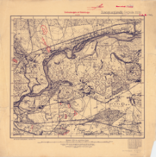
Download allTitle: Nowogeorgijewßk - Segrsche : (XXII-8-V). Bl. 18
Creator:
Prusy. Landesaufnahme. Kartographische Abteilung. Instytucja sprawcza Wydawca
Date issued/created:
Resource type:
Subtitle:
Publisher:
Place of publishing:
Description:
Umdruckausgabe mit Feldstellungen 6. 3. 15 ; Scale1:25 000 ; 1 map : color; 39x43 cm, on sheet 50x50 cm ; Bearbeitet 1914 ; The sheet of so-called series: Russische Karte des westlichen Grenzgebiets 1:25 000 ; In bottom margin sheet index and designation: 1214 ; Prime meridian Pulkovo ; Title and margin information in German, geographical names in German and Russian
Relation:
Russische Karte des westlichen Grenzgebiets 1:25 000
Detailed Resource Type:
Format:
Resource Identifier:
Source:
CBGiOŚ. IGiPZ PAN, call no. C.906/1 ; click here to follow the link
Language:
Coverage:
Rights:
Terms of use:
Digitizing institution:
Institute of Geography and Spatial Organization of the Polish Academy of Sciences
Original in:
Projects co-financed by:
Access:
Object collections:
- Digital Repository of Scientific Institutes > Partners' collections > Institute of Geography and Spatial Organization PAS (IGiPZ PAN) > Library
- Digital Repository of Scientific Institutes > Partners' collections > Institute of Geography and Spatial Organization PAS (IGiPZ PAN) > Library > Maps and atlases
- Digital Repository of Scientific Institutes > Literature > Maps/Atlases
Last modified:
Apr 6, 2021
In our library since:
Dec 18, 2019
Number of object content downloads / hits:
189
All available object's versions:
https://rcin.org.pl./publication/92606
Show description in RDF format:
Show description in RDFa format:
Show description in OAI-PMH format:
| Edition name | Date |
|---|---|
| Nowogeorgijewßk - Segrsche : (XXII-8-V). Bl. 18, [19]15 | Apr 6, 2021 |
Objects Similar
Prusy. Landesaufnahme. Kartographische Abteilung. Instytucja sprawcza Wydawca
Prusy. Landesaufnahme. Kartographische Abteilung. Instytucja sprawcza Wydawca
Prusy. Landesaufnahme. Kartographische Abteilung. Instytucja sprawcza Wydawca
Prusy. Landesaufnahme. Kartographische Abteilung. Instytucja sprawcza Wydawca
Prusy. Landesaufnahme. Kartographische Abteilung. Instytucja sprawcza Wydawca
Vogl, R. Redaktor Wallaschek, J. (18..-19..). Redaktor Radler, Karl (18..-19..). Redaktor
Prusy. Landesaufnahme. Kartographische Abteilung. Instytucja sprawcza Wydawca
Rosja. Armiâ. Glavnyj štab. Litografìâ kartografičeskago zavedenìâ. Wydawca


