- About project
- Collections
- Indexes
- Recently viewed
-
RCIN Repositories
-
 INSTYTUT ARCHEOLOGII I ETNOLOGII POLSKIEJ AKADEMII NAUK
-
 INSTYTUT BADAŃ LITERACKICH POLSKIEJ AKADEMII NAUK
-
 INSTYTUT BADAWCZY LEŚNICTWA
-
 INSTYTUT BIOLOGII DOŚWIADCZALNEJ IM. MARCELEGO NENCKIEGO POLSKIEJ AKADEMII NAUK
-
 INSTYTUT BIOLOGII SSAKÓW POLSKIEJ AKADEMII NAUK
-
 INSTYTUT CHEMII FIZYCZNEJ PAN
-
 INSTYTUT CHEMII ORGANICZNEJ PAN
-
 INSTYTUT FILOZOFII I SOCJOLOGII PAN
-
 INSTYTUT GEOGRAFII I PRZESTRZENNEGO ZAGOSPODAROWANIA PAN
-
 INSTYTUT HISTORII im. TADEUSZA MANTEUFFLA POLSKIEJ AKADEMII NAUK
-
 INSTYTUT JĘZYKA POLSKIEGO POLSKIEJ AKADEMII NAUK
-
 INSTYTUT MATEMATYCZNY PAN
-
 INSTYTUT MEDYCYNY DOŚWIADCZALNEJ I KLINICZNEJ IM.MIROSŁAWA MOSSAKOWSKIEGO POLSKIEJ AKADEMII NAUK
-
 INSTYTUT PODSTAWOWYCH PROBLEMÓW TECHNIKI PAN
-
 INSTYTUT SLAWISTYKI PAN
-
 SIEĆ BADAWCZA ŁUKASIEWICZ - INSTYTUT TECHNOLOGII MATERIAŁÓW ELEKTRONICZNYCH
-
 MUZEUM I INSTYTUT ZOOLOGII POLSKIEJ AKADEMII NAUK
-
 INSTYTUT BADAŃ SYSTEMOWYCH PAN
-
 INSTYTUT BOTANIKI IM. WŁADYSŁAWA SZAFERA POLSKIEJ AKADEMII NAUK
-
- Search in all Repository
- Literature and maps
- Archeology
- Mills database
- Natural sciences
Advanced search
Advanced search
Advanced search
Advanced search
Advanced search

Object
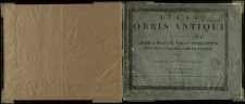
Title: Atlas Orbis Antiqui : Constans Decem et Quatuor Tabulis Geographicis, Additis Observationibus et Tabulis Historicis
Publisher:
Place of publishing:
Description:
Scales differ ; 1 atlas (12 l., [14] l. maps) : lithogr. ; 22x27 cm ; Cover title ; Designations on the maps: [l. 1A ] Sever. Oleszczyński sxc, [l. 1B.] Sev. Oleszczyński fecit, [l. 2 and 5] W. Sierociński. G.: niemy, [l. 3 and 4] T. Vivier lito., [l. 6 and 7] S.O. fec., [l. 8 and 9] Vivier f., [l. 10a and 10b] Herkner f., [l. 11 and 12] J. Herkner sculp ; Secundum guintam editionem e Germanico Latinus
Detailed Resource Type:
Format:
File size 10 MB ; image/x.djvu
Resource Identifier:
Source:
CBGiOŚ. IGiPZ PAN, sygn. B.471 ; click here to follow the link
Language:
Rights:
Terms of use:
Digitizing institution:
Institute of Geography and Spatial Organization of the Polish Academy of Sciences
Original in:
Projects co-financed by:
Programme Innovative Economy, 2010-2014, Priority Axis 2. R&D infrastructure ; European Union. European Regional Development Fund
Access:
Object collections:
- Digital Repository of Scientific Institutes > Partners' collections > Institute of Geography and Spatial Organization PAS (IGiPZ PAN) > Library
- Digital Repository of Scientific Institutes > Partners' collections > Institute of Geography and Spatial Organization PAS (IGiPZ PAN) > Library > Maps and atlases
- Digital Repository of Scientific Institutes > Literature > Maps/Atlases
Last modified:
Oct 2, 2020
In our library since:
Feb 17, 2012
Number of object content downloads / hits:
413
All available object's versions:
https://rcin.org.pl./publication/9133
Show description in RDF format:
Show description in RDFa format:
Show description in OAI-PMH format:
Objects Similar
Vivier, Teodor. Litogr. Herkner, Józef (1802–1864)
Spruner, Karl von (1803–1892)
Anville, Jean Baptiste Burguignon d' (1697–1782) Barentin de Montchal, Charles A. Louis de. Oprac.
Strabo (ca 68 a.C.-ca 26 p.C.) Müller, Karl (1855–1880) Firmin-Didot, Ambroise (1790–1876)
Lapie, Pierre (1779–1850)
Vuillemin, Alexandre A. (c. 1812 – c. 1874)
Dirwaldt, Joseph. Mollo, Tranquillo (1767–1837)


